
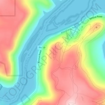
Jake's Rocks topographic map
Interactive map
Click on the map to display elevation.
About this map
Name: Jake's Rocks topographic map, elevation, terrain.
Average elevation: 1,657 ft
Minimum elevation: 1,309 ft
Maximum elevation: 2,136 ft
Pennsylvania trails, hiking, mountain biking, running and outdoor activities
Other topographic maps
Click on a map to view its topography, its elevation and its terrain.
Somerset
United States > Pennsylvania > Somerset County
Somerset has the ninth-highest elevation of towns in Pennsylvania, at 2,190 feet (670 m) above sea level. Somerset County is in Appalachia.
Average elevation: 2,172 ft
Bucks County
According to the Trewartha climate classification system, the Piedmont (United States) section of Bucks County, which is located roughly northwest of U.S. Route 1, has a Temperate Continental Climate with hot and slightly humid summers, cold winters and year-around precipitation (Dcao). Dcao climates are…
Average elevation: 322 ft
Export
United States > Pennsylvania > Westmoreland County
Export is characterized by a varied terrain that reflects its location in the Allegheny Plateau region. The borough sits at an average elevation of around 1,122 feet (342 meters) and features rolling hills and valleys typical of southwestern Pennsylvania's topography. The surrounding landscape is marked by…
Average elevation: 1,122 ft
Lake Ontelaunee Dam
United States > Pennsylvania > Berks County > Ontelaunee Township
Average elevation: 325 ft
Valley Forge National Historical Park
United States > Pennsylvania > Montgomery County > Upper Merion Township > King of Prussia
Average elevation: 174 ft
Somerset County
Somerset County along with Garrett County is one of the snowiest inhabited locations in the United States, with the highest elevations of the county averaging 150+ inches of snow each winter. The county's elevation and general proximity to both the Great Lakes and the Atlantic Ocean causes snow from both…
Average elevation: 2,073 ft
Chestnut Hill
United States > Pennsylvania > Philadelphia County > Philadelphia
The village of Chestnut Hill was part of the German Township laid out by Francis Daniel Pastorius and came to include the settlements originally known as Sommerhausen and Crefeld, as well as part of Cresheim. It served as a gateway between Philadelphia and the nearby farmlands. During the American…
Average elevation: 318 ft
Sanatoga
United States > Pennsylvania > Montgomery County > Lower Pottsgrove Township > Sanatoga
Average elevation: 279 ft
Hawley
United States > Pennsylvania > Wayne County
Hawley is located where Middle Creek enters the Lackawaxen River, at 41°28′42″N 75°10′45″W / 41.47833°N 75.17917°W / 41.47833; -75.17917 (41.478225, -75.179154) at an elevation of 1,033 feet (314.9 m). Hawley students attend Wallenpaupack Areas Schools, with high, middle, and primary…
Average elevation: 1,096 ft
McAlisterville
United States > Pennsylvania > Juniata County > Fayette Township > McAlisterville
Average elevation: 712 ft
Willow Grove
United States > Pennsylvania > Montgomery County > Upper Moreland Township > Willow Grove
Average elevation: 289 ft
Port Trevorton
United States > Pennsylvania > Snyder County > Union Township
Average elevation: 531 ft
Blue Mountain
United States > Pennsylvania > Schuylkill County > West Penn Township
The ridge of Blue Mountain runs for 150 miles (240 km) through Pennsylvania, reaching an elevation of 2,270 feet (690 m) above sea level just north of the Pennsylvania Turnpike, near the borough of Newburg. Most of the ridgecrest, however, only reaches between 1,400 and 1,700 feet (430 and 520 m) in elevation.…
Average elevation: 823 ft
Moosic Lakes
United States > Pennsylvania > Lackawanna County > Jefferson Township
Average elevation: 2,024 ft
Lake Wesauking
United States > Pennsylvania > Bradford County > Wysox Township
Average elevation: 1,165 ft
Nittany Valley
United States > Pennsylvania > Clinton County > Porter Township
Nittany Valley is in the western part of the Ridge and Valley province of the Appalachian Mountains. During the Appalachian orogeny, the sedimentary rock layers folded up into the Nittany Arch anticline. The arch was an ancient Himalayan scale mountain that towered above what is now the valley. The oldest rock…
Average elevation: 1,188 ft
Indian Rocks
United States > Pennsylvania > Lancaster County > East Cocalico Township
Average elevation: 528 ft
Lake Harmony
United States > Pennsylvania > Carbon County > Kidder Township > Lake Harmony
Average elevation: 1,864 ft
Wyncote
United States > Pennsylvania > Montgomery County > Cheltenham Township > Glenside > Wyncote
Average elevation: 285 ft
Rosegarden
United States > Pennsylvania > Cumberland County > Upper Allen Township
Average elevation: 469 ft
Crabtree Creek
United States > Pennsylvania > Westmoreland County > Salem Township > Crabtree
Average elevation: 1,119 ft