
Madison County topographic map
Interactive map
Click on the map to display elevation.
Madison County
A significant portion of western Madison County is within Shenandoah National Park, including Hawksbill Mountain, the highest point in both the park and in Madison County, Old Rag Mountain, one of the park's most popular tourist destinations, and Rapidan Camp, the presidential retreat built by Herbert Hoover. Hoover's Camp was built between 1929 and 1932. The camp consisted of 13 buildings with the main one being "The Brown House". In 2017, only three of these houses are still standing (The Brown House, The Prime Minister Cabin, and The Creel). The camp was built where two streams merge to form the Rapidan River because fishing was Hoover's favorite pastime. Hoover even made sure that the camp was built at an elevation where mosquitos would not be a nuisance while fishing. The camp was donated to the Commonwealth of Virginia in 1932 so other presidents could use it and in December 1935 it officially became a part of Shenandoah National Park.
About this map
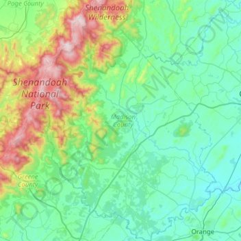
Name: Madison County topographic map, elevation, terrain.
Location: Madison County, Virginia, United States (38.23007 -78.45280 38.62731 -78.08269)
Average elevation: 1,001 ft
Minimum elevation: 269 ft
Maximum elevation: 3,990 ft
Virginia trails, hiking, mountain biking, running and outdoor activities
Other topographic maps
Click on a map to view its topography, its elevation and its terrain.
Virginia Beach
United States > Virginia > Virginia Beach
According to the United States Census Bureau, the city has a total area of 497 square miles (1,290 km2), of which 249 square miles (640 km2) is land and 248 square miles (640 km2) (49.9%) is water. It is the largest city in Virginia by total area and third-largest city land area. The average elevation is 12…
Average elevation: 7 ft
Eggleston
United States > Virginia > Giles County
It lies at an elevation of 1,821 feet.
Average elevation: 1,877 ft
Blue Ridge Mountains
United States > Virginia > Botetourt County
Although the term "Blue Ridge" is sometimes applied exclusively to the eastern edge or front range of the Appalachian Mountains, the geological definition of the Blue Ridge province extends westward to the Ridge and Valley area, encompassing the Great Smoky Mountains, the Great Balsams, the Roans, the Blacks,…
Average elevation: 1,509 ft
Prince William Forest Park
United States > Virginia > Prince William County > Triangle
Average elevation: 266 ft
Clinch Mountain
United States > Virginia > Washington County
For its entire length, Clinch Mountain has only one true gap through which the ridge is completely sliced in half and continues as Clinch Mountain on either side, divided by Big Moccasin Creek. It is named Moccasin Gap and runs between Weber City and Gate City, Virginia. The Norfolk Southern Railway and U.S.…
Average elevation: 2,028 ft
Blue Ridge Mountains
United States > Virginia > Bedford County
Although the term "Blue Ridge" is sometimes applied exclusively to the eastern edge or front range of the Appalachian Mountains, the geological definition of the Blue Ridge province extends westward to the Ridge and Valley area, encompassing the Great Smoky Mountains, the Great Balsams, the Roans, the Blacks,…
Average elevation: 1,798 ft