
龙门县 topographic map
Interactive map
Click on the map to display elevation.
About this map
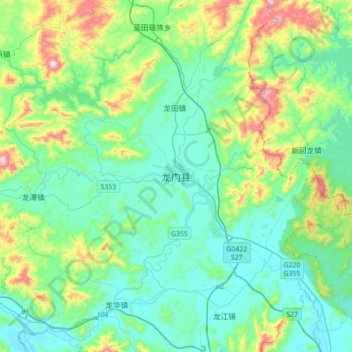
Name: 龙门县 topographic map, elevation, terrain.
Location: 龙门县, 惠州市, 广东省, 中国 (23.57049 114.09006 23.89049 114.41006)
Average elevation: 623 ft
Minimum elevation: 112 ft
Maximum elevation: 2,461 ft
东江支流——增江自东北向西南贯穿全县。地势自西北向东南倾斜,全县总面积2295平方千米,山地及丘陵占总面积的73%,平均海拔550米。
Other topographic maps
Click on a map to view its topography, its elevation and its terrain.