
Make a donation
Gear up for your next adventure:
As an Amazon Associate, this site earns from qualifying purchases at no extra cost to you.
Tiétar topographic map
Click on the map to display elevation.
Make a donation
Gear up for your next adventure:
As an Amazon Associate, this site earns from qualifying purchases at no extra cost to you.
About this map
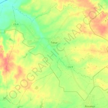
Name: Tiétar topographic map, elevation, terrain.
Location: Tiétar, Cáceres, Extremadura, 10357, España (39.99409 -5.51842 40.05097 -5.43917)
Average elevation: 915 ft
Minimum elevation: 820 ft
Maximum elevation: 997 ft
Make a donation
Gear up for your next adventure:
As an Amazon Associate, this site earns from qualifying purchases at no extra cost to you.
Other topographic maps
Click on a map to view its topography, its elevation and its terrain.
Zona de Interés Regional Embalse de Orellana y Sierra de Pela
Average elevation: 1,224 ft
Make a donation
Gear up for your next adventure:
As an Amazon Associate, this site earns from qualifying purchases at no extra cost to you.
Río Guadiana
España > Extremadura > Mérida
Una de sus múltiples fuentes, la que le otorga su nombre, se configura en la provincia española de Ciudad Real, en el manantial de los Ojos del Guadiana, situado en el término municipal de Villarrubia de los Ojos, a 608 m de altitud. Uno de los ríos que fluyen en su cabecera es el Guadiana Viejo,…
Average elevation: 728 ft
Make a donation
Gear up for your next adventure:
As an Amazon Associate, this site earns from qualifying purchases at no extra cost to you.
Make a donation
Gear up for your next adventure:
As an Amazon Associate, this site earns from qualifying purchases at no extra cost to you.
Make a donation
Gear up for your next adventure:
As an Amazon Associate, this site earns from qualifying purchases at no extra cost to you.
Make a donation
Gear up for your next adventure:
As an Amazon Associate, this site earns from qualifying purchases at no extra cost to you.
Navatrasierra
España > Extremadura > Villar del Pedroso
El pueblo está situado en la solana de la sierra de Altamira, a una altitud de unos 730 m sobre el nivel del mar. Ente las dos sierras el terreno se encuentra interrumpido por una infinidad de cerros y profundos valles por los cuales discurren las aguas de los numerosos arroyos y torrentes que llevan sus…
Average elevation: 2,598 ft
Make a donation
Gear up for your next adventure:
As an Amazon Associate, this site earns from qualifying purchases at no extra cost to you.
Badajoz
España > Extremadura > Badajoz > Badajoz
En términos geológicos, está emplazada en la Submeseta Sur. Fue fundada a orillas del Guadiana sobre un cerro de calizas paleozoicas, labrado por el río hasta dejarlo en un resalte de 60 metros de altura. En este cerro, denominado de la Muela, se encuentra la Alcazaba, uno de los principales monumentos de…
Average elevation: 692 ft
Make a donation
Gear up for your next adventure:
As an Amazon Associate, this site earns from qualifying purchases at no extra cost to you.
Alange
España > Extremadura > Alange > Alange
Alange está situado en la parte central de Extremadura, a una altitud de 323 msnm y a una distancia de 22 km de Mérida, la capital extremeña. La superficie de su término es de 160,3 km² y pertenece a la comarca de Tierra de Mérida - Vegas Bajas y al Partido judicial de Mérida.
Average elevation: 912 ft
Cilleros
España > Extremadura > Sierra de Gata > Cilleros > Cilleros
Está situado en el norte de la provincia de Cáceres, en las estribaciones de la sierra de Santa Olalla, entre extensos campos de olivos, viñedos, robles y alcornoques. Es uno de los pueblos más amplios de la provincia de Cáceres con una extensión de 208,2 km² y una altitud de 481 m sobre el nivel del mar.
Average elevation: 1,545 ft
Make a donation
Gear up for your next adventure:
As an Amazon Associate, this site earns from qualifying purchases at no extra cost to you.
Poblado Permanente de Hidroeléctrica Española
España > Extremadura > Tajo-Salor > Alcántara
Average elevation: 787 ft
Make a donation
Gear up for your next adventure:
As an Amazon Associate, this site earns from qualifying purchases at no extra cost to you.
Make a donation
Gear up for your next adventure:
As an Amazon Associate, this site earns from qualifying purchases at no extra cost to you.
Make a donation
Gear up for your next adventure:
As an Amazon Associate, this site earns from qualifying purchases at no extra cost to you.
Make a donation
Gear up for your next adventure:
As an Amazon Associate, this site earns from qualifying purchases at no extra cost to you.
Poblado Central Núclear Valdecaballeros
España > Extremadura > Valdecaballeros
Average elevation: 1,266 ft
Make a donation
Gear up for your next adventure:
As an Amazon Associate, this site earns from qualifying purchases at no extra cost to you.
Make a donation
Gear up for your next adventure:
As an Amazon Associate, this site earns from qualifying purchases at no extra cost to you.
La Carretería
España > Extremadura > Tierra de Badajoz > San Vicente de Alcántara
Average elevation: 1,079 ft
Make a donation
Gear up for your next adventure:
As an Amazon Associate, this site earns from qualifying purchases at no extra cost to you.
Make a donation
Gear up for your next adventure:
As an Amazon Associate, this site earns from qualifying purchases at no extra cost to you.
Make a donation
Gear up for your next adventure:
As an Amazon Associate, this site earns from qualifying purchases at no extra cost to you.
Make a donation
Gear up for your next adventure:
As an Amazon Associate, this site earns from qualifying purchases at no extra cost to you.
Embalse de Zalamea
España > Extremadura > Zalamea de la Serena > La Charca de Zalamea
Average elevation: 1,621 ft
Monumento Natural Los Barruecos
España > Extremadura > Malpartida de Cáceres
Average elevation: 1,184 ft
Make a donation
Gear up for your next adventure:
As an Amazon Associate, this site earns from qualifying purchases at no extra cost to you.
Río Guadiana
España > Extremadura > Guareña
Una de sus múltiples fuentes, la que le otorga su nombre, se configura en la provincia española de Ciudad Real, en el manantial de los Ojos del Guadiana, situado en el término municipal de Villarrubia de los Ojos, a 608 m de altitud. Uno de los ríos que fluyen en su cabecera es el Guadiana Viejo,…
Average elevation: 751 ft
San Francisco de Olivenza
España > Extremadura > Badajoz > Olivenza > San Francisco de Olivenza
Average elevation: 692 ft
El Raposo
España > Extremadura > Zafra - Río Bodión > Puebla de Sancho Pérez > El Raposo
Average elevation: 1,795 ft
Make a donation
Gear up for your next adventure:
As an Amazon Associate, this site earns from qualifying purchases at no extra cost to you.
Make a donation
Gear up for your next adventure:
As an Amazon Associate, this site earns from qualifying purchases at no extra cost to you.
Make a donation
Gear up for your next adventure:
As an Amazon Associate, this site earns from qualifying purchases at no extra cost to you.
Pago de San Clemente
España > Extremadura > Trujillo > Pago de San Clemente
Average elevation: 1,906 ft
Castillo de Granadilla
España > Extremadura > Cáceres > Zarza de Granadilla > Granadilla
Average elevation: 1,253 ft
Make a donation
Gear up for your next adventure:
As an Amazon Associate, this site earns from qualifying purchases at no extra cost to you.
Make a donation
Gear up for your next adventure:
As an Amazon Associate, this site earns from qualifying purchases at no extra cost to you.
Guijo de Granadilla
España > Extremadura > Trasierra-Tierras de Granadilla > Guijo de Granadilla > Guijo de Granadilla
Se sitúa en la depresión del río Alagón, sobre terreno llano a una altitud de 390 msnm.
Average elevation: 1,276 ft
Corazón de Jesús
España > Extremadura > Tierra de Badajoz > Badajoz > Corazón de Jesús
Average elevation: 594 ft
Make a donation
Gear up for your next adventure:
As an Amazon Associate, this site earns from qualifying purchases at no extra cost to you.