
Horry County topographic map
Click on the map to display elevation.
Horry County
Horry County features a diverse topography that ranges from coastal plains to elevated inland areas. The county's eastern boundary runs along the Atlantic Ocean, characterized by sandy beaches and a series of coastal barriers, which transition into marshy wetlands. Moving inland, the terrain gradually rises to gentle hills and river valleys, particularly around the Waccamaw River and its tributaries. The elevation varies, with the highest points reaching around 100 feet above sea level, while much of the region remains near sea level. The county is also dotted with numerous lakes, swamps, and forested areas, providing a rich ecological landscape that supports a variety of flora and fauna.
About this map
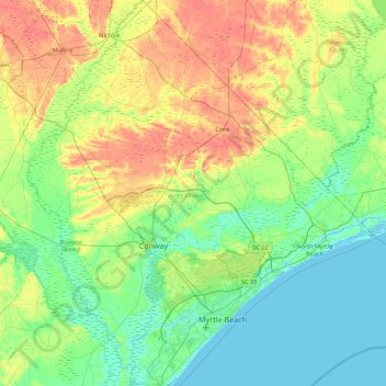
Name: Horry County topographic map, elevation, terrain.
Location: Horry County, South Carolina, United States (33.56912 -79.33911 34.29984 -78.54135)
Average elevation: 46 ft
Minimum elevation: -16 ft
Maximum elevation: 131 ft
South Carolina trails, hiking, mountain biking, running and outdoor activities
Other topographic maps
Click on a map to view its topography, its elevation and its terrain.
Windy Hill Beach
United States > South Carolina > Horry County > North Myrtle Beach
Average elevation: 7 ft
Cowpens National Battlefield
United States > South Carolina > Cherokee County
Average elevation: 938 ft
Pinewood Vista
United States > South Carolina > Charleston County > North Charleston
Average elevation: 30 ft
Cherry Grove Beach
United States > South Carolina > Horry County > North Myrtle Beach
Average elevation: 3 ft
Croft State Park
United States > South Carolina > Spartanburg County > Pauline
Average elevation: 679 ft
Dawson Park
United States > South Carolina > Pickens County > Clemson > Briarwood
Average elevation: 764 ft
Hobcaw Point
United States > South Carolina > Charleston County > Mount Pleasant
Average elevation: 13 ft
Forest I At Harbison
United States > South Carolina > Richland County > Columbia
Average elevation: 285 ft
Naval Nuclear Power Training Command
United States > South Carolina > Berkeley County > Goose Creek
Average elevation: 16 ft
South Carolina Noname 12005 D-0209 Dam
United States > South Carolina > Chester County > Mountain Lakes
Average elevation: 489 ft
Royal Pines Country Club Estates
United States > South Carolina > Beaufort County
Average elevation: 23 ft
Saint Andrews Heights
United States > South Carolina > Charleston County > Charleston
Average elevation: 16 ft
Hilton Head Plantation
United States > South Carolina > Beaufort County > Hilton Head Island
Average elevation: 20 ft
Palmetto Fort
United States > South Carolina > Charleston County > Mount Pleasant
Average elevation: 13 ft
Marietta
United States > South Carolina > Greenville County > Slater-Marietta
Average elevation: 1,040 ft