
Make a donation
Gear up for your next adventure:
As an Amazon Associate, this site earns from qualifying purchases at no extra cost to you.
Maharashtra topographic map
Click on the map to display elevation.
Make a donation
Gear up for your next adventure:
As an Amazon Associate, this site earns from qualifying purchases at no extra cost to you.
Maharashtra
Maharashtra with a total area of 307,713 km2 (118,809 sq mi), is the third-largest state by area in terms of land area and constitutes 9.36 per cent of India's total geographical area. The State lies between 15°35' N to 22°02' N latitude and 72°36' E to 80°54' E longitude. It occupies the western and central part of the country and has a coastline stretching 840 kilometres along the Arabian Sea. The dominant physical feature of the state is its plateau character, which is separated from the Konkan coastline by the mountain range of the Western Ghats, which runs parallel to the coast from north to south.The Western Ghats, also known as the Sahyadri Range, has an average elevation of 1,200 metres (4,000 ft); its slopes gently descending towards the east and southeast. The Western Ghats (or the Sahyadri Mountain range) provide a physical barrier to the state on the west, while the Satpura Hills along the north and Bhamragad-Chiroli-Gaikhuri ranges on the east serve as its natural borders. This state's expansion from North to South is 700 km and East to West is 800 km. To the west of these hills lie the Konkan coastal plains, 50–80 kilometres in width. To the east of the Ghats lies the flat Deccan Plateau. The main rivers of the state are the Krishna, and its tributary, Bhima, the Godavari, and its main tributaries, Manjara, and Wardha-Wainganga and the Tapi, and its tributary Purna. Maharashtra is divided into five geographic regions. Konkan is the western coastal region, between the Western Ghats and the sea. Khandesh is the north region lying in the valley of the Tapti, Purna river. Nashik, Malegaon Jalgaon, Dhule and Bhusawal are the major cities of this region. Desh is in the center of the state. Marathwada, which was a part of the princely state of Hyderabad until 1956, is located in the southeastern part of the state. Aurangabad and Nanded are the main cities of the region. Vidarbha is the easternmost region of the state, formerly part of the Central Provinces and Berar.
Make a donation
Gear up for your next adventure:
As an Amazon Associate, this site earns from qualifying purchases at no extra cost to you.
About this map
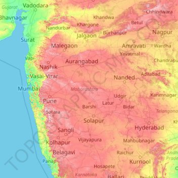
Name: Maharashtra topographic map, elevation, terrain.
Location: Maharashtra, India (15.60636 72.65261 22.03027 80.89778)
Average elevation: 1,135 ft
Minimum elevation: -3 ft
Maximum elevation: 4,652 ft
Make a donation
Gear up for your next adventure:
As an Amazon Associate, this site earns from qualifying purchases at no extra cost to you.
Other topographic maps
Click on a map to view its topography, its elevation and its terrain.
Maharashtra
Maharashtra is the third largest state by area in India. The Western Ghats better known as Sahyadri, are a hilly range running parallel to the coast, at an average elevation of 1,200 metres (4,000 ft). Kalsubai, a peak in the Sahyadris, near Nashik city is the highest elevated point in Maharashtra. To the west…
Average elevation: 1,568 ft
Mysuru
India > Karnataka > Mysuru taluk
Mysore (/maɪˈsɔːr/ (listen)), officially Mysuru ([ˈmaɪˈsuːɾu] (listen)), is a city in the southern part of the state of Karnataka, India. Mysore city is geographically located between 12° 18′ 26″ north latitude and 76° 38′ 59″ east longitude. It is located at an altitude of 770 m (2,530 ft)…
Average elevation: 2,385 ft
Make a donation
Gear up for your next adventure:
As an Amazon Associate, this site earns from qualifying purchases at no extra cost to you.
Dras
Dras (also spelt Drass, ISO transliteration: Drās), also known locally in Shina as Himababs, Hembabs, or Humas, is a town and hill station, near Kargil in the Kargil district of the union territory of Ladakh in India. It is on the NH 1 between Zoji La pass and Kargil. A tourist hub for its high-altitude…
Average elevation: 11,585 ft
Secunderabad
Situated in the North of Hyderabad at 17°27′N 78°30′E / 17.45°N 78.5°E / 17.45; 78.5., Secunderabad lies on the northern part of the Deccan Plateau. Secunderabad has an average elevation of 543 metres (1781 ft). Most of the area has a rocky terrain and some areas are hilly.
Average elevation: 1,785 ft
Thiruvananthapuram
India > Kerala > Thiruvananthapuram
Thiruvananthapuram is built on seven hills by the seashore and is at 8°30′N 76°54′E / 8.5°N 76.9°E / 8.5; 76.9 on the west coast, near the southern tip of mainland India. The city is on the west coast of India and is bounded by the Laccadive Sea to its west and the Western Ghats to its east.…
Average elevation: 108 ft
Make a donation
Gear up for your next adventure:
As an Amazon Associate, this site earns from qualifying purchases at no extra cost to you.
Dehradun
India > Uttarakhand > Dehradun
The city of Dehradun mainly lies in Doon Valley and is at a varying height from 410 m (1,350 ft) in Clement Town to above 700 m (2,300 ft) at Malsi which is 15 km (9.3 mi) from the city. However, the average elevation is 450 m (1,480 ft) above sea level. Malsi is the starting point of Lesser Himalayan Range…
Average elevation: 2,966 ft
Guwahati
Professor Abani Kumar Bhagawati of Gauhati University stated that since before there were sufficient wetlands to absorb rainwater and channels to carry excess water to the Brahmaputra, the city did not experience floods. However, human interference has disrupted the natural topography, leading to the current…
Average elevation: 371 ft
Visakhapatnam
India > Andhra Pradesh > Visakhapatnam (Urban)
The city is situated between the Eastern Ghats and the Bay of Bengal. The city's area is 682 km2. The average elevation is 45 metres. Visakhapatnam is situated in Coastal Andhra Region.
Average elevation: 115 ft
Make a donation
Gear up for your next adventure:
As an Amazon Associate, this site earns from qualifying purchases at no extra cost to you.
Make a donation
Gear up for your next adventure:
As an Amazon Associate, this site earns from qualifying purchases at no extra cost to you.
Leh
Leh (/ˈlɛ/) (Ladakhi: གླེ) is the joint capital and largest city of Ladakh, a union territory of India. Leh, located in the Leh district, was also the historical capital of the Kingdom of Ladakh, the seat of which was in the Leh Palace, the former residence of the royal family of Ladakh, built in the…
Average elevation: 14,088 ft
Navi Mumbai
India > Maharashtra > Thane > Navi Mumbai
Navi Mumbai (Marathi pronunciation: , also known by its former name New Bombay), is a planned city off the west coast of the Indian state of Maharashtra in Konkan division. The city is divided into two parts, North Navi Mumbai and South Navi Mumbai, for the individual development of Panvel Mega City, which…
Average elevation: 98 ft
Varanasi
India > Uttar Pradesh > Sadar
Varanasi is located at an elevation of 80.71 metres (264.8 ft) in the centre of the Ganges valley of North India, in the Eastern part of the state of Uttar Pradesh, along the left crescent-shaped bank of the Ganges, averaging between 15 metres (50 ft) and 21 metres (70 ft) above the river. The city is the…
Average elevation: 253 ft
Make a donation
Gear up for your next adventure:
As an Amazon Associate, this site earns from qualifying purchases at no extra cost to you.
Vadodara
India > Gujarat > Vadodara Rural Taluka
Vadodara is located at 22°18′N 73°11′E / 22.30°N 73.19°E / 22.30; 73.19 in western India at an elevation of 39 metres (128 ft). It is the tenth-largest city in India with an area of 400 square kilometres (150 sq mi) and a population of 3.5 million, according to the 2010–11 census. The city…
Average elevation: 118 ft
Madurai
India > Tamil Nadu > Madurai
Madurai is located at 9°56′N 78°07′E / 9.93°N 78.12°E / 9.93; 78.12. It has an average elevation of 101 metres. The city of Madurai lies on the flat and fertile plain of the river Vaigai, which runs in the northwest-southeast direction through the city, dividing it into two almost equal…
Average elevation: 453 ft
Chennai
Chennai is located on the south–eastern coast of India in the north–eastern part of Tamil Nadu on a flat coastal plain known as the Eastern Coastal Plains. Its average elevation is around 6.7 metres (22 ft), and its highest point is 60 m (200 ft). Chennai is 2,184 kilometres (1,357 mi) south of Delhi,…
Average elevation: 23 ft
Make a donation
Gear up for your next adventure:
As an Amazon Associate, this site earns from qualifying purchases at no extra cost to you.
Visakhapatnam
India > Andhra Pradesh > Visakhapatnam (Urban)
The city is situated between the Eastern Ghats and the Bay of Bengal. The city coordinates lies between 17.7041 N and 83.2977 E. The city's area is 682 km2. The average elevation is 45 metres. Visakhpatnam is situated in Coastal Andhra Region.
Average elevation: 115 ft
Mumbai
Mumbai lies at the mouth of the Ulhas River on the western coast of India, in the coastal region known as the Konkan. It sits on Salsette Island (Sashti Island), which it partially shares with the Thane district. Mumbai is bounded by the Arabian Sea to the west. Many parts of the city lie just above sea level,…
Average elevation: 43 ft
Make a donation
Gear up for your next adventure:
As an Amazon Associate, this site earns from qualifying purchases at no extra cost to you.
Make a donation
Gear up for your next adventure:
As an Amazon Associate, this site earns from qualifying purchases at no extra cost to you.
Make a donation
Gear up for your next adventure:
As an Amazon Associate, this site earns from qualifying purchases at no extra cost to you.
Make a donation
Gear up for your next adventure:
As an Amazon Associate, this site earns from qualifying purchases at no extra cost to you.
Bhavnagar
India > Gujarat > Bhavnagar Taluka
Bhavnagar is a coastal city on the eastern coast of Saurashtra, also known as Kathiawar, located at 21°46′N 72°09′E / 21.77°N 72.15°E / 21.77; 72.15. It has an average elevation of 24 metres (78 ft). It occupies an area of 53.3 km2 (20.6 sq mi) and 5th most populated city of Gujarat. The…
Average elevation: 75 ft
Make a donation
Gear up for your next adventure:
As an Amazon Associate, this site earns from qualifying purchases at no extra cost to you.
Gorakhpur
India > Uttar Pradesh > Gorakhpur
Gorakhpur city is located in the north-easterrn part of Uttar Pradesh, India, within the Indo-Gangetic Plain. The city's geographical coordinates are 26.7663° N latitude and 83.3689° E longitude, with an altitude of 69 metres (229 feet) above sea level. Gorakhpur is situated about 100 km from the Nepal…
Average elevation: 259 ft
Make a donation
Gear up for your next adventure:
As an Amazon Associate, this site earns from qualifying purchases at no extra cost to you.
Make a donation
Gear up for your next adventure:
As an Amazon Associate, this site earns from qualifying purchases at no extra cost to you.
Lansdowne
India > Uttarakhand > Lansdowne
Lansdowne is a quaint hill station in the Pauri Garhwal district of Uttarakhand, India. Lodged in the picturesque surroundings of the Himalayan ranges, it lies at an elevation of approximately 1,700 meters (5,577 feet) above sea level. The town is about 45 kilometers (28 miles) from the district headquarters,…
Average elevation: 3,740 ft
Kullu
India > Himachal Pradesh > Kullu
Kullu town has an average elevation of 1,278 m (4,193 ft). It lies on the bank of Beas River. A major tributary, Sarvari, (derived from "Shiv-Baardi") leads to the less explored and steeper Lug-valley on the west. On the east of Kullu lies a broad mountainous ridge having the village-temples of Bijli Mahadev,…
Average elevation: 5,932 ft
Make a donation
Gear up for your next adventure:
As an Amazon Associate, this site earns from qualifying purchases at no extra cost to you.
Podakkudi
India > Tamil Nadu > Needamangalam
Podakkudi is located at 10°44′12″N 79°30′02″E / 10.736667°N 79.500556°E / 10.736667; 79.500556. Rivers Vennar and Vettar, which flows on the two edges of the village, keeps the soil fertile. The topography is completely flat and the town is a part of the fertile Cauvery Delta. Podakkudi is…
Average elevation: 49 ft
Vandalur
India > Tamil Nadu > Chengalpattu
Vandalur hill is part of Arignar Anna Zoological Park and public entry to the hill is restricted. The hilltop provides a good view of the OMR and Mannivakam. The Tamil Nadu Forest department has a sapling center under the foothill of Vandalur hill. The run has a total ascent of 274.99 ft and has a maximum…
Average elevation: 89 ft
Jowai
India > Meghalaya > Thadlaskein
Jowai (IPA: ʤəʊˈwaɪ) is the headquarters of the West Jaintia Hills district of the state of Meghalaya, India, and is home to the Pnar, a sub-tribe of the Khasi people. It is located on a plateau surrounded on three sides by the Myntdu river bordering Bangladesh to the south (about 50 km from the…
Average elevation: 4,370 ft
Make a donation
Gear up for your next adventure:
As an Amazon Associate, this site earns from qualifying purchases at no extra cost to you.
Make a donation
Gear up for your next adventure:
As an Amazon Associate, this site earns from qualifying purchases at no extra cost to you.
Make a donation
Gear up for your next adventure:
As an Amazon Associate, this site earns from qualifying purchases at no extra cost to you.
Panvel
India > Maharashtra > Panvel > Panvel
Matheran is a hill station and a municipal council in the Raigad district in the Indian state of Maharashtra. It is a hill station in Karjat Tahsil and is also the smallest hill station in India. It is located on the Western Ghats range at an elevation of around 800 m (2,625 feet) above sea level. It is…
Average elevation: 246 ft
Western Ghats
The range starts near south of the Tapti river and runs approximately 1,600 km (990 mi) through the states of Gujarat, Maharashtra, Karnataka, Goa, Kerala and Tamil Nadu ending at Marunthuvazh Malai near the southern tip of India. These hills cover 160,000 km2 (62,000 sq mi) and form the catchment area for…
Average elevation: 7,300 ft
Make a donation
Gear up for your next adventure:
As an Amazon Associate, this site earns from qualifying purchases at no extra cost to you.
Chengalpattu
India > Tamil Nadu > Chengalpattu
Chengalpattu is located at 12°42′N 79°59′E / 12.7°N 79.98°E / 12.7; 79.98. It has an average elevation of 36 metres (118 ft). Lake Kolavai is the largest located in Chengalpattu.
Average elevation: 157 ft
Lucknow
India > Uttar Pradesh > Lucknow
The city stands at an elevation of approximately 123 metres (404 ft) above sea level. Lucknow city had an area of 402 km2 (155 square miles) till December 2019, when 88 villages were added to the municipal limits and the area increased to 631 km2 (244 square miles). Bounded on the east by Barabanki, on the…
Average elevation: 394 ft
Make a donation
Gear up for your next adventure:
As an Amazon Associate, this site earns from qualifying purchases at no extra cost to you.
Siliguri
India > West Bengal > Matigara block
Siliguri located at the foothills of the eastern Himalayas at a location of 26°43′N 88°26′E / 26.71°N 88.43°E / 26.71; 88.43. This city is spread over an area of 260 km2 within the Siliguri Corridor, also known as the Chicken's neck. The city is surrounded by dense forests towards north and…
Average elevation: 397 ft
Make a donation
Gear up for your next adventure:
As an Amazon Associate, this site earns from qualifying purchases at no extra cost to you.
Ranchi
Ranchi lies at 23°22′N 85°20′E / 23.36°N 85.33°E / 23.36; 85.33 near to the Tropic of Cancer. The city covers an area of 175 km2 (68 sq mi) and its average elevation is 651 m above sea level. Ranchi is located in the southern part of the Chota Nagpur plateau, which is the eastern section of…
Average elevation: 2,126 ft
Make a donation
Gear up for your next adventure:
As an Amazon Associate, this site earns from qualifying purchases at no extra cost to you.
Make a donation
Gear up for your next adventure:
As an Amazon Associate, this site earns from qualifying purchases at no extra cost to you.
Make a donation
Gear up for your next adventure:
As an Amazon Associate, this site earns from qualifying purchases at no extra cost to you.
Make a donation
Gear up for your next adventure:
As an Amazon Associate, this site earns from qualifying purchases at no extra cost to you.
Make a donation
Gear up for your next adventure:
As an Amazon Associate, this site earns from qualifying purchases at no extra cost to you.