Geolocate

Hancock County topographic map

Click on the map to display elevation.

About this map

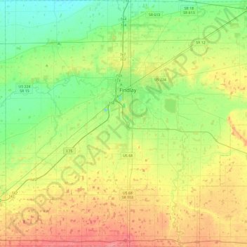
Name: Hancock County topographic map, elevation, terrain.

Location: Hancock County, Ohio, United States (40.81798 -83.88116 41.16839 -83.42030)

Average elevation: 820 ft

Minimum elevation: 709 ft

Maximum elevation: 991 ft

Ohio trails, hiking, mountain biking, running and outdoor activities

Other topographic maps

Click on a map to view its topography, its elevation and its terrain.

Beverly Hills

United States > Ohio > Clermont County

Average elevation: 666 ft

Lake Lorelei

United States > Ohio > Brown County > Vera Cruz

Average elevation: 945 ft

West Chester

United States > Ohio > Butler County > West Chester

Average elevation: 758 ft

Serpent Mound

United States > Ohio > Adams County

The mound is located on the site of a classic astrobleme, an ancient meteorite impact structure. One of the strongest clues to the impact origin of this structure is in the pattern of disruption of sedimentary strata. In the center of the structure, strata have been uplifted several hundred feet, in much the…

Average elevation: 741 ft

Winton Woods

United States > Ohio

Average elevation: 751 ft

Columbus

United States > Ohio > Franklin County > Columbus

The confluence of the Scioto and Olentangy rivers is just north-west of Downtown Columbus. Several smaller tributaries course through the Columbus metropolitan area, including Alum Creek, Big Walnut Creek, and Darby Creek. Columbus is considered to have relatively flat topography thanks to a large glacier that…

Average elevation: 837 ft

Fort McKinley

United States > Ohio > Montgomery County > Dayton

Average elevation: 896 ft

Polo

United States > Ohio > Miami County

Average elevation: 974 ft

Walnut Creek

United States > Ohio > Holmes County

Average elevation: 1,073 ft

Marshall

United States > Ohio > Highland County

Average elevation: 981 ft

Lemert

United States > Ohio > Crawford County

Average elevation: 958 ft

Columbus Feeder

United States > Ohio > Franklin County > Columbus

Average elevation: 699 ft

Fox Acres

United States > Ohio > Hamilton County > Cincinnati

Average elevation: 856 ft

Colton

United States > Ohio > Henry County

Average elevation: 676 ft

Eldean

United States > Ohio > Miami County

Average elevation: 873 ft

Huntcrest Acres

United States > Ohio > Hamilton County

Average elevation: 827 ft

Vulcan

United States > Ohio > Lucas County > Toledo

Average elevation: 623 ft

Camp Crowell Dam

United States > Ohio > Summit County

Average elevation: 1,165 ft

East Cambridge

United States > Ohio > Guernsey County > Cambridge

Average elevation: 856 ft

Russell

United States > Ohio > Highland County

Average elevation: 1,053 ft

Dillon Lake

United States > Ohio > Muskingum County

Average elevation: 846 ft

Upper Dayton View

United States > Ohio > Montgomery County > Dayton

Average elevation: 863 ft

Tedrow

United States > Ohio > Fulton County > Tedrow

Average elevation: 761 ft

Avon Center

United States > Ohio > Lorain County > Avon

Average elevation: 659 ft

Mount Lookout

United States > Ohio > Auglaize County

Average elevation: 1,037 ft

Brookville

United States > Ohio > Athens County

Average elevation: 774 ft

Pharisburg

United States > Ohio > Union County

Average elevation: 958 ft

Crescent

United States > Ohio > Belmont County

Average elevation: 1,030 ft

Homer

United States > Ohio > Licking County

Average elevation: 1,020 ft

Moss Run

United States > Ohio > Washington County

Average elevation: 820 ft

Hammondsville

United States > Ohio > Jefferson County

Average elevation: 961 ft

Buena Vista

United States > Ohio > Scioto County

Average elevation: 722 ft

Towner's Woods

United States > Ohio > Portage County

Average elevation: 1,079 ft

Beaver Island

United States > Ohio > Mahoning County > Boardman

Average elevation: 1,076 ft

Rose Lake

United States > Ohio > Hocking County

Average elevation: 968 ft

Hickory Grove

United States > Ohio > Ottawa County

Average elevation: 571 ft

Cuyahoga River

United States > Ohio > Cuyahoga County > Cleveland

The upper Cuyahoga River, starting at 1,093 feet (333 m) over 84 miles (135 km) from its mouth, drops in elevation fairly steeply, creating falls and rapids in some places; the lower Cuyahoga River only drops several feet along the last several miles of the lower river to 571 feet (174 m) at the mouth on Lake…

Average elevation: 643 ft

Maumee River

United States > Ohio > Lucas County > Maumee

Average elevation: 617 ft

Cleveland

United States > Ohio > Cuyahoga County > Cleveland

The land rises quickly from the lake shore elevation of 569 feet. Public Square, less than one mile (1.6 km) inland, sits at an elevation of 650 feet (198 m), and Hopkins Airport, 5 miles (8 km) inland from the lake, is at an elevation of 791 feet (241 m).

Average elevation: 725 ft

Cincinnati

United States > Ohio > Hamilton County

Cincinnati has several standard modes of transportation including sidewalks, roads, public transit, bicycle paths and airports. The city's hills preclude the regular street grid common to many cities built up in the 19th century, and outside of the downtown basin, regular street grids are rare except for in…

Average elevation: 738 ft

Westgate Park

United States > Ohio > Franklin County > Columbus

Average elevation: 830 ft

Creola

United States > Ohio > Vinton County

Average elevation: 840 ft

Williamsfield

United States > Ohio > Ashtabula County

Average elevation: 1,132 ft

Lake Cable

United States > Ohio > Stark County

Average elevation: 1,115 ft

Rose Lake Dam

United States > Ohio > Hocking County

Average elevation: 974 ft

Willow Glen

United States > Ohio > Tuscarawas County > Dover

Average elevation: 922 ft

Windsor

United States > Ohio > Ashtabula County

Average elevation: 873 ft

Herbert Corners

United States > Ohio > Mahoning County

Average elevation: 1,129 ft

Newbury

United States > Ohio > Geauga County

Average elevation: 1,204 ft

Welshfield

United States > Ohio > Geauga County > Troy Township

Average elevation: 1,155 ft

Summit Park

United States > Ohio > Hamilton County > Blue Ash

Average elevation: 833 ft

The Highlands

United States > Ohio > Muskingum County

Average elevation: 919 ft

Tealtown Ball Park

United States > Ohio > Clermont County

Average elevation: 709 ft

Mayfield

United States > Ohio > Butler County > Middletown

Average elevation: 696 ft

Oak Ridge

United States > Ohio > Montgomery County > Centerville

Average elevation: 978 ft

Alfred

United States > Ohio > Meigs County

Average elevation: 748 ft

Chaska Beach

United States > Ohio > Erie County > Huron

Average elevation: 581 ft

North Baltimore

United States > Ohio > Wood County

Average elevation: 719 ft

Brukner Park

United States > Ohio > Miami County > Troy

Average elevation: 840 ft

Sagamore Hills

United States > Ohio > Summit County

Average elevation: 866 ft

Claylick

United States > Ohio > Licking County

Average elevation: 846 ft

Spring Mountain

United States > Ohio > Coshocton County

Average elevation: 1,070 ft

Burr Oak State Park

United States > Ohio > Morgan County

Average elevation: 823 ft

Campbell Hill

United States > Ohio > Logan County > Bellefontaine

Campbell Hill is, at 1,549.09 feet (472.16 m), the highest point in elevation in the U.S. state of Ohio. Campbell Hill is located within the city of Bellefontaine, 2 miles (3.2 km) northeast of downtown.

Average elevation: 1,457 ft

Wolf Run

United States > Ohio > Jefferson County

Average elevation: 1,178 ft

Rockbridge

United States > Ohio > Hocking County

Average elevation: 860 ft

Dundee

United States > Ohio > Tuscarawas County

Average elevation: 1,076 ft

Dunlap

United States > Ohio > Hamilton County

Average elevation: 741 ft

Lake Mohawk

United States > Ohio > Carroll County

Average elevation: 1,093 ft

Highpoint

United States > Ohio > Hamilton County

Average elevation: 866 ft

Wolfhurst

United States > Ohio > Belmont County

Average elevation: 971 ft

Etna

United States > Ohio > Licking County

Etna (formerly Carthage) is an unincorporated community and census-designated place (CDP) in Licking County, Ohio, United States. As of the 2020 census it had a population of 1,209. It lies at an elevation of 1,069 feet (326 m) at the intersection of U.S. Route 40 and State Route 310. It was listed as a…

Average elevation: 1,053 ft

Symmes

United States > Ohio > Hamilton County

Average elevation: 696 ft

Villa Nova

United States > Ohio > Auglaize County

Average elevation: 883 ft

Slater

United States > Ohio > Auglaize County

Average elevation: 1,020 ft

Santa Fe

United States > Ohio > Auglaize County

Average elevation: 1,007 ft

Glynwood

United States > Ohio > Auglaize County

Average elevation: 876 ft

Gutman

United States > Ohio > Auglaize County

Average elevation: 1,020 ft

Kossuth

United States > Ohio > Auglaize County

Average elevation: 840 ft

Lock Two

United States > Ohio > Auglaize County

Average elevation: 935 ft

Moulton

United States > Ohio > Auglaize County

Average elevation: 889 ft

Egypt

United States > Ohio > Auglaize County

Average elevation: 968 ft

Fryburg

United States > Ohio > Auglaize County

Average elevation: 991 ft

Geyer

United States > Ohio > Auglaize County

Average elevation: 1,027 ft

Gear up for your next adventure:

💧Water Filtration Bottles - Safely drink from streams and lakes while exploring
📱Heavy-Duty Phone Cases - Drop-proof and waterproof protection for outdoor navigation
Backpacking Tent - Lightweight and durable tent for multi‑day hikes
🗻Climbing Gear Basics - Essential gear for beginner climbers
📖Nature Tracking Books - Learn to track wildlife and terrain

As an Amazon Associate, this site earns from qualifying purchases at no extra cost to you.