
Jaunpur topographic map
Click on the map to display elevation.
About this map
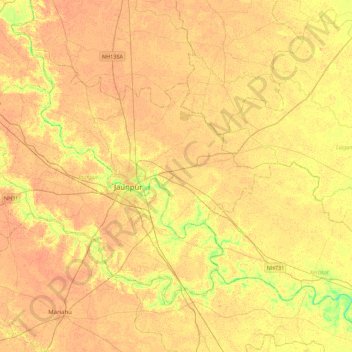
Name: Jaunpur topographic map, elevation, terrain.
Location: Jaunpur, Jaunpur District, Uttar Pradesh, India (25.61510 82.42583 25.90229 82.86867)
Average elevation: 272 ft
Minimum elevation: 203 ft
Maximum elevation: 295 ft
Other topographic maps
Click on a map to view its topography, its elevation and its terrain.
Ayodhya
India > Uttar Pradesh > Faizabad
The earliest of the Buddhist Pali-language texts and the Jain Prakrit-language texts mention a city called Saketa (Sageya or Saeya in Prakrit) as an important city of the Kosala mahajanapada. Topographical indications in both Buddhist and Jain texts suggest that Saketa is the same as the present-day Ayodhya.…
Average elevation: 315 ft
Varanasi
India > Uttar Pradesh > Sadar
Varanasi is located at an elevation of 80.71 metres (264.8 ft) in the centre of the Ganges valley of North India, in the Eastern part of the state of Uttar Pradesh, along the left crescent-shaped bank of the Ganges, averaging between 15 metres (50 ft) and 21 metres (70 ft) above the river. The city is the…
Average elevation: 253 ft
Agra
India > Uttar Pradesh > Agra
The region around Agra consists almost entirely of a level plain, with hills in the extreme southwest. The rivers in the region include Yamuna and Chambal. The region is also watered by the Agra Canal. Millet, barley, wheat and cotton are among the crops grown in the surrounding countryside. Both Rabi and…
Average elevation: 545 ft
Lucknow
India > Uttar Pradesh > Lucknow
The city stands at an elevation of approximately 123 metres (404 ft) above sea level. Lucknow city had an area of 402 km2 (155 square miles) till December 2019, when 88 villages were added to the municipal limits and the area increased to 631 km2 (244 square miles). Bounded on the east by Barabanki, on the…
Average elevation: 394 ft
Sandila
India > Uttar Pradesh > Sandila
Sandila is located at 27°05′N 80°31′E / 27.08°N 80.52°E / 27.08; 80.52. It has an average elevation of 142 metres (466 ft). It is around 50 kilometres away from district headquarters and also 50 kilometres away from Lucknow, the capital of Uttar Pradesh and is an important tehsil of the Hardoi district.
Average elevation: 430 ft
Agra
India > Uttar Pradesh > Agra
The region around Agra consists almost entirely of a level plain, with hills in the extreme southwest. The rivers in the region include Yamuna and Chambal. The region is also watered by the Agra Canal. Millet, barley, wheat and cotton are among the crops grown in the surrounding countryside. Both Rabi and…
Average elevation: 545 ft
Prayagraj
India > Uttar Pradesh > Allahabad
Prayagraj's elevation is over 90 m (295 ft) above sea level. The old part of the city, at the south of Prayagraj Junction railway station, consists of neighbourhoods like Chowk, Johnstongunj, Dariyabad, Khuldabad and many more. In the north of the Railway Station, the new city consists of neighbourhoods like…
Average elevation: 299 ft
Mirzapur
India > Uttar Pradesh > Mirzapur
Mirzapur is located at 25°09′N 82°35′E / 25.15°N 82.58°E / 25.15; 82.58. It has an average elevation of 80 metres (265 feet). The District of Mirzapur lies between the parallels of 23.52 & 25.32 North latitude and 82.7 and 83.33 East longitude. It forms a portion of the Varanasi district. On…
Average elevation: 272 ft
Vrindavan
India > Uttar Pradesh > Mathura
Vrindavan is situated on the west bank of the Yamuna River, about 15 kilometres north of Mathura. "Maps, Weather, and Airports for Vrindavan, India". www.fallingrain.com. Retrieved 6 December 2019.</ref> It has an average elevation of 170 metres (557 feet).
Average elevation: 564 ft
Gorakhpur
India > Uttar Pradesh > Gorakhpur
Gorakhpur city is located in the north-easterrn part of Uttar Pradesh, India, within the Indo-Gangetic Plain. The city's geographical coordinates are 26.7663° N latitude and 83.3689° E longitude, with an altitude of 69 metres (229 feet) above sea level. Gorakhpur is situated about 100 km from the Nepal…
Average elevation: 259 ft
Maurawan
India > Uttar Pradesh > Purwa
Maurawan is located at 26°26′N 80°53′E / 26.43°N 80.88°E / 26.43; 80.88. It has an average elevation of 121 metres (397 ft). Maurawan is 55 kilometres (34 mi) from Lucknow, 42 kilometres (26 mi) from Unnao, 45 kilometres (28 mi) from Rai Baraily and 62 kilometres (39 mi) from Kanpur. The…
Average elevation: 397 ft
Bahraich
India > Uttar Pradesh > Bahraich
It has an average elevation of 126 metres (413 feet). Bahraich has a warm humid subtropical climate with hot summers from April to July. The rainy season is from July to mid-September when Bahraich gets an average rainfall from the south-west monsoon winds, and occasionally frontal rainfall will occur in…
Average elevation: 394 ft
Hastinapur
India > Uttar Pradesh > Mawana
Present-day Hastinapur is a town in the Doab region of Uttar Pradesh in India, about 37 kilometres (23 mi) from Meerut and nearly 96 km (60 mi) north-east of Delhi on National Highway 34. It is a small township re-established by Jawaharlal Nehru on February 6, 1949, located at 29°10′N 78°01′E /…
Average elevation: 741 ft
Chandauli
India > Uttar Pradesh > Chandauli
Chandauli is located at 25°16′N 83°16′E / 25.27°N 83.27°E / 25.27; 83.27. It has an average elevation of 70 metres (230 ft). Located about 30 kilometers from Varanasi, it comes under Varanasi division of Uttar Pradesh. Mughalsarai, a major railway junction between northern and eastern India is…
Average elevation: 249 ft
Hardoi
India > Uttar Pradesh > Hardoi
Hardoi is located at 27°25′N 80°07′E / 27.42°N 80.12°E / 27.42; 80.12. It has an average elevation of 134 metres (440 ft). Hardoi is located 110 km from Lucknow (capital of Uttar Pradesh) and 394 from New Delhi (capital of India). The Ganges and several of its tributaries are crossing the…
Average elevation: 463 ft
Lakhimpur
India > Uttar Pradesh > Lakhimpur
Lakhimpur is located at 27°57′N 80°46′E / 27.95°N 80.77°E / 27.95; 80.77. It has an average elevation of 147 metres (482 ft).
Average elevation: 463 ft
Charkhari
India > Uttar Pradesh > Charkhari
Charkhari is located at 25°24′N 79°45′E / 25.4°N 79.75°E / 25.4; 79.75. It has an average elevation of 184 metres (603 feet). Charkhari is also known as the 'Kashmir of Bundelkhand'. The town is surrounded by many lakes. There are lakes named Vijay Sagar, Malkhan Sagar, Vanshi Sagar, Jai…
Average elevation: 607 ft