
长陔乡 topographic map
Interactive map
Click on the map to display elevation.
About this map
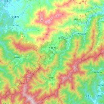
Name: 长陔乡 topographic map, elevation, terrain.
Location: 长陔乡, 歙县, 黄山市, 安徽省, 中国 (29.57879 118.47787 29.72936 118.59435)
Average elevation: 1,949 ft
Minimum elevation: 453 ft
Maximum elevation: 4,334 ft
Other topographic maps
Click on a map to view its topography, its elevation and its terrain.