
Make a donation
Gear up for your next adventure:
As an Amazon Associate, this site earns from qualifying purchases at no extra cost to you.
Almoloya topographic map
Click on the map to display elevation.
Make a donation
Gear up for your next adventure:
As an Amazon Associate, this site earns from qualifying purchases at no extra cost to you.
Almoloya
Almoloya se localiza al sur del territorio hidalguense entre los paralelos 19° 37’ y 19° 51’ de latitud norte; los meridianos 98° 11’ y 98° 27’ de longitud oeste; con una altitud entre 2600 y 3300 m s. n. m. Este municipio cuenta con una superficie de 272.31 km², y representa el 1.31 % de la superficie del estado; dentro de la región geográfica denominada como la Altiplanicie pulquera.
Make a donation
Gear up for your next adventure:
As an Amazon Associate, this site earns from qualifying purchases at no extra cost to you.
About this map
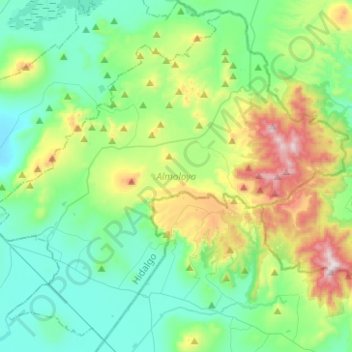
Name: Almoloya topographic map, elevation, terrain.
Location: Almoloya, Hidalgo, México (19.62821 -98.44310 19.84825 -98.19352)
Average elevation: 8,868 ft
Minimum elevation: 8,100 ft
Maximum elevation: 11,073 ft
Make a donation
Gear up for your next adventure:
As an Amazon Associate, this site earns from qualifying purchases at no extra cost to you.
Other topographic maps
Click on a map to view its topography, its elevation and its terrain.
Pachuca
México > Hidalgo > Pachuca de Soto
Le corresponden las coordenadas geográficas 20° 07’ 18” de latitud norte y 98° 44’ 09” de longitud oeste; además de contar una altitud entre 2382 y 2400 metros sobre el nivel del mar. En 2015 registró un índice de desarrollo humano de 0.834 (Muy Alto); ocupando el segundo lugar a nivel…
Average elevation: 8,068 ft
Make a donation
Gear up for your next adventure:
As an Amazon Associate, this site earns from qualifying purchases at no extra cost to you.
Make a donation
Gear up for your next adventure:
As an Amazon Associate, this site earns from qualifying purchases at no extra cost to you.
Make a donation
Gear up for your next adventure:
As an Amazon Associate, this site earns from qualifying purchases at no extra cost to you.
Make a donation
Gear up for your next adventure:
As an Amazon Associate, this site earns from qualifying purchases at no extra cost to you.
Pedregal de San Francisco
México > Hidalgo > Tulancingo de Bravo > Fraccionamiento del Magisterio Tulancinguense
Average elevation: 7,156 ft
Make a donation
Gear up for your next adventure:
As an Amazon Associate, this site earns from qualifying purchases at no extra cost to you.
Make a donation
Gear up for your next adventure:
As an Amazon Associate, this site earns from qualifying purchases at no extra cost to you.
Make a donation
Gear up for your next adventure:
As an Amazon Associate, this site earns from qualifying purchases at no extra cost to you.
Make a donation
Gear up for your next adventure:
As an Amazon Associate, this site earns from qualifying purchases at no extra cost to you.
Make a donation
Gear up for your next adventure:
As an Amazon Associate, this site earns from qualifying purchases at no extra cost to you.
Ciudad Sahagún
México > Hidalgo > Tepeapulco
Se encuentra en los llanos de Apan, le corresponden las coordenadas geográficas 19° 46’ 21.741” de latitud norte y 98° 34’ 54.852” de longitud oeste, con una altitud de 2448 m s. n. m. Cuenta con un clima semiseco templado y templado subhúmedo con lluvias en verano, de menor humedad.
Average elevation: 8,192 ft
Make a donation
Gear up for your next adventure:
As an Amazon Associate, this site earns from qualifying purchases at no extra cost to you.
Parque Nacional El Chico
México > Hidalgo > Mineral del Chico > Mineral del Chico
Average elevation: 9,058 ft
Make a donation
Gear up for your next adventure:
As an Amazon Associate, this site earns from qualifying purchases at no extra cost to you.
Centro de Desarrollo Cd. Sahagún
México > Hidalgo > Tepeapulco > Ciudad Sahagún
Average elevation: 8,068 ft
Make a donation
Gear up for your next adventure:
As an Amazon Associate, this site earns from qualifying purchases at no extra cost to you.
Make a donation
Gear up for your next adventure:
As an Amazon Associate, this site earns from qualifying purchases at no extra cost to you.
Make a donation
Gear up for your next adventure:
As an Amazon Associate, this site earns from qualifying purchases at no extra cost to you.
Make a donation
Gear up for your next adventure:
As an Amazon Associate, this site earns from qualifying purchases at no extra cost to you.
Colonia Felipe Ángeles
México > Hidalgo > Santiago Tulantepec de Lugo Guerrero
Average elevation: 7,411 ft
Santiago Tulantepec
México > Hidalgo > Santiago Tulantepec de Lugo Guerrero
Se encuentra en la región geográfica del Valle de Tulancingo. A la localidad le corresponden las coordenadas geográficas 20°2′23″ de latitud norte y 98°21′27″ de longitud oeste, con una altitud de 2174 m s. n. m. Se localiza a una distancia de 51 kilómetros de Pachuca de Soto.
Average elevation: 7,415 ft
Make a donation
Gear up for your next adventure:
As an Amazon Associate, this site earns from qualifying purchases at no extra cost to you.
Make a donation
Gear up for your next adventure:
As an Amazon Associate, this site earns from qualifying purchases at no extra cost to you.
Mineral del Chico
México > Hidalgo > Mineral del Chico
Se encuentra en la región geográfica de la Comarca Minera, en la Sierra de Pachuca; a la localidad le corresponden las coordenadas geográficas 20° 12’ 56.054” de latitud norte y 98° 43’ 52.424” de longitud oeste, con una altitud de 2358 m s. n. m. Cuenta con un clima templado subhúmedo con…
Average elevation: 8,235 ft
Make a donation
Gear up for your next adventure:
As an Amazon Associate, this site earns from qualifying purchases at no extra cost to you.
Make a donation
Gear up for your next adventure:
As an Amazon Associate, this site earns from qualifying purchases at no extra cost to you.
Make a donation
Gear up for your next adventure:
As an Amazon Associate, this site earns from qualifying purchases at no extra cost to you.
Make a donation
Gear up for your next adventure:
As an Amazon Associate, this site earns from qualifying purchases at no extra cost to you.
Make a donation
Gear up for your next adventure:
As an Amazon Associate, this site earns from qualifying purchases at no extra cost to you.
Make a donation
Gear up for your next adventure:
As an Amazon Associate, this site earns from qualifying purchases at no extra cost to you.
Make a donation
Gear up for your next adventure:
As an Amazon Associate, this site earns from qualifying purchases at no extra cost to you.
Make a donation
Gear up for your next adventure:
As an Amazon Associate, this site earns from qualifying purchases at no extra cost to you.