
Make a donation
Gear up for your next adventure:
As an Amazon Associate, this site earns from qualifying purchases at no extra cost to you.
徽县 topographic map
Click on the map to display elevation.
Make a donation
Gear up for your next adventure:
As an Amazon Associate, this site earns from qualifying purchases at no extra cost to you.
About this map
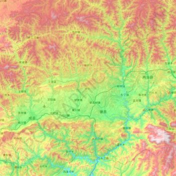
Name: 徽县 topographic map, elevation, terrain.
Location: 徽县, 陇南市, 甘肃省, 742300, 中国 (33.54811 105.57405 34.17748 106.44879)
Average elevation: 4,551 ft
Minimum elevation: 2,270 ft
Maximum elevation: 8,146 ft
Make a donation
Gear up for your next adventure:
As an Amazon Associate, this site earns from qualifying purchases at no extra cost to you.
Other topographic maps
Click on a map to view its topography, its elevation and its terrain.
积石山县
中国 > 甘肃省 > 积石山保安族东乡族撒拉族自治县
该县西邻青海省海东市循化县;北部以黄河为界,分别与青海省民和县及甘肃永靖县相接。小积石山位于该县西部 ;被视为祁连山东延部分,境内最高峰为海拔约4309米的雷帝山(又称雷积山)。
Average elevation: 7,995 ft
兰州市
兰州是甘肃省省会,位于中国陆域版图的几何中心,市区是典型的带状城市形态,地处黄河上游,位于河谷盆地。四季分明,冬无严寒,夏无酷暑。市区海拔1520米。黄河自东西穿城而过,是唯一一个黄河穿越市区的省会城市。由于南北两山夹峙地形的影响,市区东西狭长,约30千米,南北最窄处,仅1千米左右,最宽处约5~6千米,具有带状盆地城市的特征。地势西部和南部高,东北低,黄河自西南流向东北,横穿全境,切穿山岭,形成峡谷与盆地相间的串珠形河谷。峡谷有八盘峡、柴家峡、桑园峡、大峡、乌金峡等;盆地有新城盆地、兰州盆地、泥湾一什川盆地、青城一水川盆地等。还有湟水谷地、庄浪河谷地、苑川河谷地、大通河谷地等。
Average elevation: 6,017 ft
Make a donation
Gear up for your next adventure:
As an Amazon Associate, this site earns from qualifying purchases at no extra cost to you.
Make a donation
Gear up for your next adventure:
As an Amazon Associate, this site earns from qualifying purchases at no extra cost to you.
Make a donation
Gear up for your next adventure:
As an Amazon Associate, this site earns from qualifying purchases at no extra cost to you.
Make a donation
Gear up for your next adventure:
As an Amazon Associate, this site earns from qualifying purchases at no extra cost to you.
甘南州
甘南藏族自治州南与四川阿坝州相连,西南与青海黄南州、果洛州接壤,东部和北部与陇南市、定西市、临夏州毗邻,总面积38521平方千米。甘南藏族自治州位于青藏高原东北边缘,地处青藏高原、黄土高原和陇南山地的过渡地带。地势西北高,东南低,由西北向东南呈倾斜状。西南部的积石山系,西北部的西倾山系与南部的岷山-迭山山系形成州境地貌的主要构架。州境平均海拔3000~4000米,舟曲县瓜子沟口为最低点,海拔1172米。境内的主要河流有黄河、洮河、大夏河和白龙江,洮河、大夏河流域属黄河水系,白龙江流域属长江水系。州境所辖的玛曲、碌曲、卓尼、临潭、夏河5县境属黄河流域,迭部、舟曲两县全境及碌曲县的郎木寺一带属长江流域。
Average elevation: 10,089 ft
Make a donation
Gear up for your next adventure:
As an Amazon Associate, this site earns from qualifying purchases at no extra cost to you.
Make a donation
Gear up for your next adventure:
As an Amazon Associate, this site earns from qualifying purchases at no extra cost to you.
Make a donation
Gear up for your next adventure:
As an Amazon Associate, this site earns from qualifying purchases at no extra cost to you.
Make a donation
Gear up for your next adventure:
As an Amazon Associate, this site earns from qualifying purchases at no extra cost to you.
Make a donation
Gear up for your next adventure:
As an Amazon Associate, this site earns from qualifying purchases at no extra cost to you.
Make a donation
Gear up for your next adventure:
As an Amazon Associate, this site earns from qualifying purchases at no extra cost to you.
Make a donation
Gear up for your next adventure:
As an Amazon Associate, this site earns from qualifying purchases at no extra cost to you.
Make a donation
Gear up for your next adventure:
As an Amazon Associate, this site earns from qualifying purchases at no extra cost to you.
Make a donation
Gear up for your next adventure:
As an Amazon Associate, this site earns from qualifying purchases at no extra cost to you.
Make a donation
Gear up for your next adventure:
As an Amazon Associate, this site earns from qualifying purchases at no extra cost to you.
Make a donation
Gear up for your next adventure:
As an Amazon Associate, this site earns from qualifying purchases at no extra cost to you.
Make a donation
Gear up for your next adventure:
As an Amazon Associate, this site earns from qualifying purchases at no extra cost to you.
Make a donation
Gear up for your next adventure:
As an Amazon Associate, this site earns from qualifying purchases at no extra cost to you.
Make a donation
Gear up for your next adventure:
As an Amazon Associate, this site earns from qualifying purchases at no extra cost to you.
张掖丹霞国家地质公园
临泽丹霞景区是公园的核心区域,距张掖市区以西30公里(19英里),临泽县城以南20公里(12英里)。这是整个公园发展最为完善,游客人数最多的一个景区。 第二大景区冰沟位于梨园河北岸,于2014年8月3日正式揭牌。 冰沟占地总面积为300平方公里(120平方英里),海拔1500-2500米。 第三大景区肃南丹霞景区位于甘肃省临泽县。
Average elevation: 5,771 ft
Make a donation
Gear up for your next adventure:
As an Amazon Associate, this site earns from qualifying purchases at no extra cost to you.
Make a donation
Gear up for your next adventure:
As an Amazon Associate, this site earns from qualifying purchases at no extra cost to you.
Make a donation
Gear up for your next adventure:
As an Amazon Associate, this site earns from qualifying purchases at no extra cost to you.
Make a donation
Gear up for your next adventure:
As an Amazon Associate, this site earns from qualifying purchases at no extra cost to you.
Make a donation
Gear up for your next adventure:
As an Amazon Associate, this site earns from qualifying purchases at no extra cost to you.
Make a donation
Gear up for your next adventure:
As an Amazon Associate, this site earns from qualifying purchases at no extra cost to you.
Make a donation
Gear up for your next adventure:
As an Amazon Associate, this site earns from qualifying purchases at no extra cost to you.