
香泉镇 topographic map
Interactive map
Click on the map to display elevation.
About this map
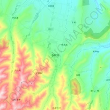
Name: 香泉镇 topographic map, elevation, terrain.
Location: 香泉镇, 安定区, 定西市, 甘肃省, 中国 (35.38834 104.47160 35.46834 104.55160)
Average elevation: 7,162 ft
Minimum elevation: 6,644 ft
Maximum elevation: 8,117 ft
Other topographic maps
Click on a map to view its topography, its elevation and its terrain.