
Make a donation
Gear up for your next adventure:
As an Amazon Associate, this site earns from qualifying purchases at no extra cost to you.
Windham topographic map
Click on the map to display elevation.
Make a donation
Gear up for your next adventure:
As an Amazon Associate, this site earns from qualifying purchases at no extra cost to you.
About this map
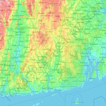
Name: Windham topographic map, elevation, terrain.
Location: Windham, Connecticut, 01532, United States (41.12083 -72.70512 42.52083 -71.30512)
Average elevation: 331 ft
Minimum elevation: -20 ft
Maximum elevation: 1,916 ft
Connecticut trails, hiking, mountain biking, running and outdoor activities
Make a donation
Gear up for your next adventure:
As an Amazon Associate, this site earns from qualifying purchases at no extra cost to you.
Other topographic maps
Click on a map to view its topography, its elevation and its terrain.
Make a donation
Gear up for your next adventure:
As an Amazon Associate, this site earns from qualifying purchases at no extra cost to you.
Ridgefield
United States > Connecticut > Ridgefield
Ridgefield consists of hilly, rocky terrain, ranging from 1,060 feet (320 m) above sea level (at Pine Mountain) to 342 feet (104 m) at Branchville. Its average village elevation is 725 feet (221 m) above sea level. The landscape is strewn with countless rocks deposited by glaciers, and among the town's bodies…
Average elevation: 600 ft
Central Waterford CDP
United States > Connecticut > Southeastern Connecticut Planning Region > Waterford
Average elevation: 72 ft
Essex Village
United States > Connecticut > Lower Connecticut River Valley Planning Region > Essex
Average elevation: 72 ft
Baltic
United States > Connecticut > Southeastern Connecticut Planning Region > Sprague
Average elevation: 266 ft
Make a donation
Gear up for your next adventure:
As an Amazon Associate, this site earns from qualifying purchases at no extra cost to you.
Westbrook Center
United States > Connecticut > Lower Connecticut River Valley Planning Region > Westbrook
Average elevation: 23 ft
Coventry Lake
United States > Connecticut > Capitol Planning Region > Coventry
Average elevation: 597 ft
Pawcatuck
United States > Connecticut > Southeastern Connecticut Planning Region > Stonington
Average elevation: 85 ft
Salmon Brook
United States > Connecticut > Capitol Planning Region > East Granby > Carroll Corners
Average elevation: 197 ft
Make a donation
Gear up for your next adventure:
As an Amazon Associate, this site earns from qualifying purchases at no extra cost to you.
Wallingford Center CDP
United States > Connecticut > South Central Connecticut Planning Region > Wallingford
Average elevation: 197 ft
Avery Pond
United States > Connecticut > Southeastern Connecticut Planning Region > Preston
Average elevation: 167 ft
Field Park
United States > Connecticut > Lower Connecticut River Valley Planning Region > Middletown > Newfield Heights
Average elevation: 128 ft
Make a donation
Gear up for your next adventure:
As an Amazon Associate, this site earns from qualifying purchases at no extra cost to you.
Ridgefield
United States > Connecticut > Western Connecticut Planning Region > Ridgefield
Average elevation: 673 ft
Clinton
United States > Connecticut > Lower Connecticut River Valley Planning Region
Average elevation: 89 ft
Make a donation
Gear up for your next adventure:
As an Amazon Associate, this site earns from qualifying purchases at no extra cost to you.
Terramuggus
United States > Connecticut > Capitol Planning Region > Marlborough > Terramuggus > Four Corners
Average elevation: 492 ft
Southwood Acres
United States > Connecticut > Capitol Planning Region > Enfield
Average elevation: 115 ft
Sherwood Manor
United States > Connecticut > Capitol Planning Region > Enfield > Thompsonville
Average elevation: 148 ft
Make a donation
Gear up for your next adventure:
As an Amazon Associate, this site earns from qualifying purchases at no extra cost to you.
Canton Valley
United States > Connecticut > Capitol Planning Region > Canton
Average elevation: 486 ft
Mill River Park
United States > Connecticut > Western Connecticut Planning Region > Stamford
Average elevation: 59 ft
East Hampton
United States > Connecticut > Lower Connecticut River Valley Planning Region > East Hampton
Average elevation: 469 ft
Make a donation
Gear up for your next adventure:
As an Amazon Associate, this site earns from qualifying purchases at no extra cost to you.
New London County
United States > Connecticut > Southeastern Connecticut Planning Region
Average elevation: 240 ft
New Milford
United States > Connecticut > Western Connecticut Planning Region > New Milford
Average elevation: 525 ft
Glastonbury Center
United States > Connecticut > Capitol Planning Region > Glastonbury > South Glastonbury
Average elevation: 108 ft
Brookfield
United States > Connecticut > Western Connecticut Planning Region
Average elevation: 456 ft
Make a donation
Gear up for your next adventure:
As an Amazon Associate, this site earns from qualifying purchases at no extra cost to you.
Central Manchester
United States > Connecticut > Capitol Planning Region > Manchester
Average elevation: 233 ft
Make a donation
Gear up for your next adventure:
As an Amazon Associate, this site earns from qualifying purchases at no extra cost to you.
Bethel
United States > Connecticut > Western Connecticut Planning Region > Bethel
Average elevation: 472 ft
Danbury
United States > Connecticut > Fairfield County > Danbury
According to the United States Census Bureau, Danbury has a total area of 44.3 square miles (115 km2), of which 42.1 square miles (109 km2) is land and 2.2 square miles (5.7 km2), or 4.94%, is water. The city is located in the foothills of the Berkshire Mountains on low-lying land just south of Candlewood Lake…
Average elevation: 574 ft
Make a donation
Gear up for your next adventure:
As an Amazon Associate, this site earns from qualifying purchases at no extra cost to you.
Montville
United States > Connecticut > Southeastern Connecticut Planning Region
Average elevation: 262 ft
Bridgewater
United States > Connecticut > Western Connecticut Planning Region
Average elevation: 456 ft
Make a donation
Gear up for your next adventure:
As an Amazon Associate, this site earns from qualifying purchases at no extra cost to you.
Niantic
United States > Connecticut > Southeastern Connecticut Planning Region > East Lyme > Niantic
Average elevation: 39 ft
Putnam Memorial State Park
United States > Connecticut > Western Connecticut Planning Region > Redding
Average elevation: 705 ft
Make a donation
Gear up for your next adventure:
As an Amazon Associate, this site earns from qualifying purchases at no extra cost to you.
Norwalk River
United States > Connecticut > Western Connecticut Planning Region > Wilton > Cannondale
Average elevation: 348 ft
Avon Place/Fieldcrest Play Area
United States > Connecticut > Southeastern Connecticut Planning Region > Groton > Old Mystic
Average elevation: 118 ft
Lordship Beach
United States > Connecticut > Greater Bridgeport Planning Region > Stratford > Lordship
Average elevation: 3 ft
Fort Trumbull State Park
United States > Connecticut > Southeastern Connecticut Planning Region > New London
Average elevation: 39 ft
Make a donation
Gear up for your next adventure:
As an Amazon Associate, this site earns from qualifying purchases at no extra cost to you.
William E. Wolfe Park
United States > Connecticut > Greater Bridgeport Planning Region > Monroe > Stepney
Average elevation: 423 ft
Cheshire Village
United States > Connecticut > Naugatuck Valley Planning Region > Cheshire
Average elevation: 220 ft
Madison Center
United States > Connecticut > South Central Connecticut Planning Region > Madison
Average elevation: 26 ft
Make a donation
Gear up for your next adventure:
As an Amazon Associate, this site earns from qualifying purchases at no extra cost to you.
Darien Pond
United States > Connecticut > Western Connecticut Planning Region > New Canaan
Average elevation: 233 ft
Franklin Park
United States > Connecticut > Southeastern Connecticut Planning Region > Norwich
Average elevation: 128 ft
Pocotopaug Lake
United States > Connecticut > Lower Connecticut River Valley Planning Region > East Hampton > Lake Pocotopaug
Average elevation: 512 ft
Make a donation
Gear up for your next adventure:
As an Amazon Associate, this site earns from qualifying purchases at no extra cost to you.
Chester Center
United States > Connecticut > Lower Connecticut River Valley Planning Region > Chester
Average elevation: 171 ft
Sprague
United States > Connecticut > Southeastern Connecticut Planning Region
Average elevation: 253 ft
Simsbury Center
United States > Connecticut > Capitol Planning Region > Simsbury
Average elevation: 272 ft
Terryville
United States > Connecticut > Naugatuck Valley Planning Region > Plymouth > Terryville
Average elevation: 689 ft
Make a donation
Gear up for your next adventure:
As an Amazon Associate, this site earns from qualifying purchases at no extra cost to you.
Compo
United States > Connecticut > Western Connecticut Planning Region > Westport
Average elevation: 33 ft
Georgetown
United States > Connecticut > Western Connecticut Planning Region > Wilton
Average elevation: 469 ft
Greens Farms
United States > Connecticut > Western Connecticut Planning Region > Westport
Average elevation: 33 ft
Maltby Lakes West Dam
United States > Connecticut > South Central Connecticut Planning Region > West Haven
Average elevation: 197 ft
Make a donation
Gear up for your next adventure:
As an Amazon Associate, this site earns from qualifying purchases at no extra cost to you.
Mamanasco Lake Dam
United States > Connecticut > Western Connecticut Planning Region > Ridgefield
Average elevation: 689 ft
Gay City State Park
United States > Connecticut > Capitol Planning Region > Hebron
Average elevation: 558 ft
Pameacha Pond
United States > Connecticut > Lower Connecticut River Valley Planning Region > Middletown
Average elevation: 135 ft
Make a donation
Gear up for your next adventure:
As an Amazon Associate, this site earns from qualifying purchases at no extra cost to you.
Dooley Pond
United States > Connecticut > Lower Connecticut River Valley Planning Region > Middletown
Average elevation: 318 ft
East Brooklyn
United States > Connecticut > Northeastern Connecticut Planning Region > East Brooklyn
Average elevation: 240 ft
Lake Plymouth Dam
United States > Connecticut > Naugatuck Valley Planning Region > Plymouth
Average elevation: 692 ft
Thomaston Rod & Gun Club
United States > Connecticut > Northwest Hills Planning Region > Litchfield
Average elevation: 915 ft
Make a donation
Gear up for your next adventure:
As an Amazon Associate, this site earns from qualifying purchases at no extra cost to you.
Durham
United States > Connecticut > Lower Connecticut River Valley Planning Region > Durham
Average elevation: 282 ft
Northwest Harwinton
United States > Connecticut > Northwest Hills Planning Region > Harwinton
Average elevation: 827 ft
Sharon Avenue Park
United States > Connecticut > Northwest Hills Planning Region > Torrington
Average elevation: 751 ft
Essex
United States > Connecticut > Lower Connecticut River Valley Planning Region
Average elevation: 85 ft
Make a donation
Gear up for your next adventure:
As an Amazon Associate, this site earns from qualifying purchases at no extra cost to you.
Wickham Park
United States > Connecticut > Capitol Planning Region > Manchester
Average elevation: 131 ft
Squantz Pond State Park
United States > Connecticut > Fairfield County > New Fairfield > Lakeside Woods
Average elevation: 745 ft
Make a donation
Gear up for your next adventure:
As an Amazon Associate, this site earns from qualifying purchases at no extra cost to you.
Lake Pocotopaug
United States > Connecticut > Middlesex County > East Hampton
Average elevation: 571 ft
Make a donation
Gear up for your next adventure:
As an Amazon Associate, this site earns from qualifying purchases at no extra cost to you.
No Mans Land Swamp (Natural)
United States > Connecticut > Morris > Lakeside
Average elevation: 925 ft
Make a donation
Gear up for your next adventure:
As an Amazon Associate, this site earns from qualifying purchases at no extra cost to you.
Middlefield
United States > Connecticut > Lower Connecticut River Valley Planning Region
Average elevation: 331 ft
West Haven
United States > Connecticut > New Haven County > West Haven > West Haven
Average elevation: 69 ft
Poquonock Bridge
United States > Connecticut > Southeastern Connecticut Planning Region > Groton > Poquonock Bridge
Average elevation: 66 ft
Make a donation
Gear up for your next adventure:
As an Amazon Associate, this site earns from qualifying purchases at no extra cost to you.
Collinsville
United States > Connecticut > Hartford County > Canton > Collinsville > Collinsville
Average elevation: 486 ft
Dayville
United States > Connecticut > Windham County > Killingly > Dayville
Average elevation: 299 ft
Make a donation
Gear up for your next adventure:
As an Amazon Associate, this site earns from qualifying purchases at no extra cost to you.