
Make a donation
Gear up for your next adventure:
As an Amazon Associate, this site earns from qualifying purchases at no extra cost to you.
湖里区 topographic map
Click on the map to display elevation.
Make a donation
Gear up for your next adventure:
As an Amazon Associate, this site earns from qualifying purchases at no extra cost to you.
About this map
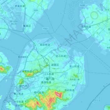
Name: 湖里区 topographic map, elevation, terrain.
Location: 湖里区, 厦门市, 福建省, 中国 (24.47939 118.06337 24.58096 118.25942)
Average elevation: 49 ft
Minimum elevation: -20 ft
Maximum elevation: 1,073 ft
Make a donation
Gear up for your next adventure:
As an Amazon Associate, this site earns from qualifying purchases at no extra cost to you.
Other topographic maps
Click on a map to view its topography, its elevation and its terrain.
Make a donation
Gear up for your next adventure:
As an Amazon Associate, this site earns from qualifying purchases at no extra cost to you.
Make a donation
Gear up for your next adventure:
As an Amazon Associate, this site earns from qualifying purchases at no extra cost to you.
泉州市
泉州市土地总面积11015平方千米(不含金门县),4/5的面积为山地丘陵。地势由西北向東南倾斜,呈三级阶梯状分布,可分为西北部中、低山区,中部低山、丘陵、河谷平原区和东南沿海丘陵、台地、平原区三个地貌区。西北部戴雲山脈,有「閩中屋脊」之称,主峰戴雲山海拔1856米;德化和永春、安溪的西部山地廣布,海拔1500米以上的山峰有29座,1000米以上的山峰数百座;河谷、盆地错落其间,是泉州市地势最高的第一级阶梯。東南部地势較为开闊。戴云山脉延伸部分的山地、丘陵和河谷平原相间排列,屬泉州市地势的第二级阶梯。沿海丘陵、台地和缓、连绵分布,海拔多在200米以下;晋江中下游的泉州平原是福建省的第四大平原,属地勢的第三级阶梯。第三…
Average elevation: 112 ft
Make a donation
Gear up for your next adventure:
As an Amazon Associate, this site earns from qualifying purchases at no extra cost to you.
Make a donation
Gear up for your next adventure:
As an Amazon Associate, this site earns from qualifying purchases at no extra cost to you.
Make a donation
Gear up for your next adventure:
As an Amazon Associate, this site earns from qualifying purchases at no extra cost to you.
Make a donation
Gear up for your next adventure:
As an Amazon Associate, this site earns from qualifying purchases at no extra cost to you.
Make a donation
Gear up for your next adventure:
As an Amazon Associate, this site earns from qualifying purchases at no extra cost to you.
Make a donation
Gear up for your next adventure:
As an Amazon Associate, this site earns from qualifying purchases at no extra cost to you.
Make a donation
Gear up for your next adventure:
As an Amazon Associate, this site earns from qualifying purchases at no extra cost to you.
Make a donation
Gear up for your next adventure:
As an Amazon Associate, this site earns from qualifying purchases at no extra cost to you.
Make a donation
Gear up for your next adventure:
As an Amazon Associate, this site earns from qualifying purchases at no extra cost to you.
Make a donation
Gear up for your next adventure:
As an Amazon Associate, this site earns from qualifying purchases at no extra cost to you.
Make a donation
Gear up for your next adventure:
As an Amazon Associate, this site earns from qualifying purchases at no extra cost to you.
Make a donation
Gear up for your next adventure:
As an Amazon Associate, this site earns from qualifying purchases at no extra cost to you.
南平市
境内地形地貌受构造运动的影响强烈、构造地貌特征相当明显,山脉多呈东北--西南走向。低山丘陵分布广,河谷地形呈峡谷或“V”、“U”状镶嵌该市各地,山间盆谷地沿河交替分布,山地切割明显,高差悬殊,以断裂为主的断块山,山峰陡峭,断层崖、断裂谷等断层地貌分布广。中山集中分布于西北、东北和西南部,由武夷山、杉岭、仙霞岭、鹫峰山4大山脉构成地形走势。中部和南部以低山丘陵盆地为主。土地总面积2.63万平方公里,其中海拔1000米以上的土地占总面积12.09%,海拔500-1000米的占44.03%,海拔300-500米的占21.38%,海拔300米以下的占22.50%。
Average elevation: 869 ft
Make a donation
Gear up for your next adventure:
As an Amazon Associate, this site earns from qualifying purchases at no extra cost to you.
福鼎市
福鼎因其境内山太姥山之覆鼎峰而得名。福鼎市位于福建宁德市东北沿海,有福建「北大门」之称。北纬26°52'─27°26',东经119°55'─120°43'。面积1526.3平方公里,海域面积14959.7平方公里。山地和丘陵地面积占士地面积88.1%,平原占11.9%。现有耕地28.47万亩,山地527平方公里,森林覆盖率65%。海岸线曲折,长度432.7公里,福鼎三面环山,一面临海,地势由东北、西北、西南向东南沿海倾斜。全市最高峰青龙山海拔1141米。大小岛礁达200多个,其中岛屿81个,主要有福瑶列岛、星仔列岛、台山列岛;主要港湾41个,其中沙埕港融商贸、渔业、军事为一体,是东南沿海重要的深水避风良埠,可建数座…
Average elevation: 915 ft
Make a donation
Gear up for your next adventure:
As an Amazon Associate, this site earns from qualifying purchases at no extra cost to you.
Make a donation
Gear up for your next adventure:
As an Amazon Associate, this site earns from qualifying purchases at no extra cost to you.
Make a donation
Gear up for your next adventure:
As an Amazon Associate, this site earns from qualifying purchases at no extra cost to you.
Make a donation
Gear up for your next adventure:
As an Amazon Associate, this site earns from qualifying purchases at no extra cost to you.
Make a donation
Gear up for your next adventure:
As an Amazon Associate, this site earns from qualifying purchases at no extra cost to you.
Make a donation
Gear up for your next adventure:
As an Amazon Associate, this site earns from qualifying purchases at no extra cost to you.
Make a donation
Gear up for your next adventure:
As an Amazon Associate, this site earns from qualifying purchases at no extra cost to you.
Make a donation
Gear up for your next adventure:
As an Amazon Associate, this site earns from qualifying purchases at no extra cost to you.
Make a donation
Gear up for your next adventure:
As an Amazon Associate, this site earns from qualifying purchases at no extra cost to you.
Make a donation
Gear up for your next adventure:
As an Amazon Associate, this site earns from qualifying purchases at no extra cost to you.