
Make a donation
Gear up for your next adventure:
As an Amazon Associate, this site earns from qualifying purchases at no extra cost to you.
仓山区 topographic map
Click on the map to display elevation.
Make a donation
Gear up for your next adventure:
As an Amazon Associate, this site earns from qualifying purchases at no extra cost to you.
About this map
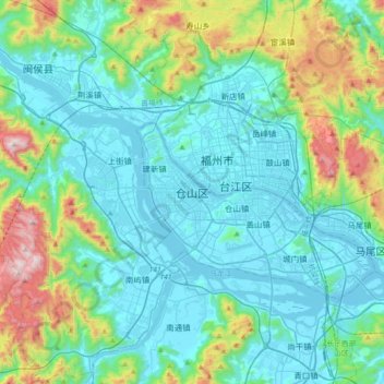
Name: 仓山区 topographic map, elevation, terrain.
Location: 仓山区, 福州市, 福建省, 350002, 中国 (25.88998 119.10857 26.20998 119.42857)
Average elevation: 640 ft
Minimum elevation: -10 ft
Maximum elevation: 3,301 ft
Make a donation
Gear up for your next adventure:
As an Amazon Associate, this site earns from qualifying purchases at no extra cost to you.
Other topographic maps
Click on a map to view its topography, its elevation and its terrain.
Make a donation
Gear up for your next adventure:
As an Amazon Associate, this site earns from qualifying purchases at no extra cost to you.
泉州市
泉州市土地总面积11015平方千米(不含金门县),4/5的面积为山地丘陵。地势由西北向東南倾斜,呈三级阶梯状分布,可分为西北部中、低山区,中部低山、丘陵、河谷平原区和东南沿海丘陵、台地、平原区三个地貌区。西北部戴雲山脈,有「閩中屋脊」之称,主峰戴雲山海拔1856米;德化和永春、安溪的西部山地廣布,海拔1500米以上的山峰有29座,1000米以上的山峰数百座;河谷、盆地错落其间,是泉州市地势最高的第一级阶梯。東南部地势較为开闊。戴云山脉延伸部分的山地、丘陵和河谷平原相间排列,屬泉州市地势的第二级阶梯。沿海丘陵、台地和缓、连绵分布,海拔多在200米以下;晋江中下游的泉州平原是福建省的第四大平原,属地勢的第三级阶梯。第三…
Average elevation: 945 ft
福安市
福安地势从北向南倾斜。西部为洞宫—鹫峰山脉东南坡,全市最高峰白云山(海拔1449米)即位于穆云乡。东部中低山地属太姥山脉西南坡,山势较陡、沟谷纵横。两侧山地夹着中部河谷丘陵至白马港入海。福建省五大水系之一的交溪纵贯福安市全境,理论水能蕴藏量34.1万千瓦,可开发12.2万千瓦,已建有闽东、穆阳等多个梯级水电站。 交溪沿岸山谷和冲击平原为福安市主要产粮区(即甘棠洋、湾坞洋、溪柄洋、柏柱洋、溪北洋等“五大洋”,“洋”即平地义)上游长溪、白石溪在潭头镇合流后称交溪,流经市区段称富春溪。至溪柄镇茜洋溪汇入;至赛岐镇穆阳溪汇入。赛岐以下称赛江,赛江下游为白马河、白马港。河口白马门外即三沙湾,与台湾海峡相通。
Average elevation: 1,568 ft
Make a donation
Gear up for your next adventure:
As an Amazon Associate, this site earns from qualifying purchases at no extra cost to you.
Make a donation
Gear up for your next adventure:
As an Amazon Associate, this site earns from qualifying purchases at no extra cost to you.
三明市
三明市东接福州,南邻泉州,西连龙岩,北毗南平,西北靠江西。位于福建省中部偏西,沙溪中部沿岸,闽西北戴云山和武夷山脉之中,是具有中国南方典型特色的内陆山区城市。东西宽230多千米,南北长180多千米,面积22928.8平方千米。三明境内以中低山及丘陵为主,北西部为武夷山脉,中部为玳瑁山脉,东南角依傍戴云山脉。峰峦耸峙,低丘起伏,溪流密布,河谷与盆地错落其间,全境地势总体上西南部高,北东部低,海拔最高(建宁白石顶)1858米,最低50米。山地占总面积82%,耕地占8.3%,水域及其他占9.7%,有“八山一水一分田”之称。主要河流有沙溪、金溪、尤溪等,水力资源可供电力装机135万千瓦。
Average elevation: 1,699 ft
Make a donation
Gear up for your next adventure:
As an Amazon Associate, this site earns from qualifying purchases at no extra cost to you.
Make a donation
Gear up for your next adventure:
As an Amazon Associate, this site earns from qualifying purchases at no extra cost to you.
Make a donation
Gear up for your next adventure:
As an Amazon Associate, this site earns from qualifying purchases at no extra cost to you.
南平市
境内地形地貌受构造运动的影响强烈、构造地貌特征相当明显,山脉多呈东北--西南走向。低山丘陵分布广,河谷地形呈峡谷或“V”、“U”状镶嵌该市各地,山间盆谷地沿河交替分布,山地切割明显,高差悬殊,以断裂为主的断块山,山峰陡峭,断层崖、断裂谷等断层地貌分布广。中山集中分布于西北、东北和西南部,由武夷山、杉岭、仙霞岭、鹫峰山4大山脉构成地形走势。中部和南部以低山丘陵盆地为主。土地总面积2.63万平方公里,其中海拔1000米以上的土地占总面积12.09%,海拔500-1000米的占44.03%,海拔300-500米的占21.38%,海拔300米以下的占22.50%。
Average elevation: 1,722 ft
Make a donation
Gear up for your next adventure:
As an Amazon Associate, this site earns from qualifying purchases at no extra cost to you.
Make a donation
Gear up for your next adventure:
As an Amazon Associate, this site earns from qualifying purchases at no extra cost to you.
长乐区
唐武德六年(623年)由闽县析立,取《诗经》“宅新邑,宁厥止”之义,县名为“新宁”,县治设敦素里平川(今古槐),不久改称长乐县。武則天聖曆二年(699年),析出长乐南部的太平、感德、崇德、孝义、万安、长东、永乐、永福8个乡,设置万安县(今福清市)。上元元年(760年),防御史董玠因敦素里地形卑湿,将县治移到吴航头。进人五代十国时期,后梁乾化元年(911年),改县名为安昌县;后唐同光元年(923年),复名长乐县;长兴四年(933年),王延钧称帝福州,国号大闽,改元龙启,升福州为长乐府,以闽县为长乐县,以长乐县为侯官县,以侯官县为闽兴县;清泰二年(935年),闽县、侯官、长乐均复旧名;后晋天福六年(941年),改闽县为…
Average elevation: 410 ft
Make a donation
Gear up for your next adventure:
As an Amazon Associate, this site earns from qualifying purchases at no extra cost to you.
Make a donation
Gear up for your next adventure:
As an Amazon Associate, this site earns from qualifying purchases at no extra cost to you.
Make a donation
Gear up for your next adventure:
As an Amazon Associate, this site earns from qualifying purchases at no extra cost to you.
Make a donation
Gear up for your next adventure:
As an Amazon Associate, this site earns from qualifying purchases at no extra cost to you.
Make a donation
Gear up for your next adventure:
As an Amazon Associate, this site earns from qualifying purchases at no extra cost to you.
Make a donation
Gear up for your next adventure:
As an Amazon Associate, this site earns from qualifying purchases at no extra cost to you.
Make a donation
Gear up for your next adventure:
As an Amazon Associate, this site earns from qualifying purchases at no extra cost to you.
Make a donation
Gear up for your next adventure:
As an Amazon Associate, this site earns from qualifying purchases at no extra cost to you.
Make a donation
Gear up for your next adventure:
As an Amazon Associate, this site earns from qualifying purchases at no extra cost to you.
Make a donation
Gear up for your next adventure:
As an Amazon Associate, this site earns from qualifying purchases at no extra cost to you.
Make a donation
Gear up for your next adventure:
As an Amazon Associate, this site earns from qualifying purchases at no extra cost to you.
Make a donation
Gear up for your next adventure:
As an Amazon Associate, this site earns from qualifying purchases at no extra cost to you.
福鼎市
福鼎因其境内山太姥山之覆鼎峰而得名。福鼎市位于福建宁德市东北沿海,有福建「北大门」之称。北纬26°52'─27°26',东经119°55'─120°43'。面积1526.3平方公里,海域面积14959.7平方公里。山地和丘陵地面积占士地面积88.1%,平原占11.9%。现有耕地28.47万亩,山地527平方公里,森林覆盖率65%。海岸线曲折,长度432.7公里,福鼎三面环山,一面临海,地势由东北、西北、西南向东南沿海倾斜。全市最高峰青龙山海拔1141米。大小岛礁达200多个,其中岛屿81个,主要有福瑶列岛、星仔列岛、台山列岛;主要港湾41个,其中沙埕港融商贸、渔业、军事为一体,是东南沿海重要的深水避风良埠,可建数座…
Average elevation: 820 ft
Make a donation
Gear up for your next adventure:
As an Amazon Associate, this site earns from qualifying purchases at no extra cost to you.
大田县
大田县东邻德化县,南连永春县,西南毗漳平县,西界永安市,西北交三元区,北接尤溪县,面积2294平方千米,地处戴云山西坡,地势由西南向东北倾斜,最高峰大仙峰海拔1553.4米,多年平均气温19.1°C,无霜期年均289天,年均日照时数1513小时,年均降水量1550.2毫米,年均降雨日数162天,降雨集中在3到9月,境内河流分属闽江、九龙江、晋江流域,河流多年平均径流量19.79亿立方米,地下水总量3.54亿立方米,主要河流有均溪、仙峰溪、文江溪和桃源溪,最大的均溪境内干流长81.7公里,森林面积232.45万亩,森林覆盖率69.49%,共有植物141科621种,其中中国国家一级保护植物5种,二级保护植物16种。
Average elevation: 2,264 ft
Make a donation
Gear up for your next adventure:
As an Amazon Associate, this site earns from qualifying purchases at no extra cost to you.
Make a donation
Gear up for your next adventure:
As an Amazon Associate, this site earns from qualifying purchases at no extra cost to you.
Make a donation
Gear up for your next adventure:
As an Amazon Associate, this site earns from qualifying purchases at no extra cost to you.
Make a donation
Gear up for your next adventure:
As an Amazon Associate, this site earns from qualifying purchases at no extra cost to you.