
马尾区 topographic map
Interactive map
Click on the map to display elevation.
About this map
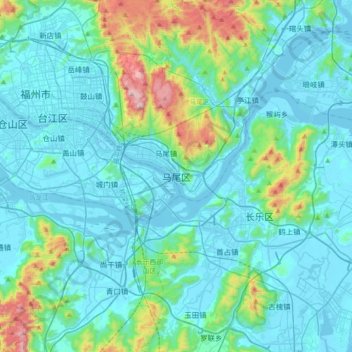
Name: 马尾区 topographic map, elevation, terrain.
Location: 马尾区, 福州市, 福建省, 350015, 中国 (25.84161 119.27434 26.16161 119.59434)
Average elevation: 433 ft
Minimum elevation: -10 ft
Maximum elevation: 2,949 ft
Other topographic maps
Click on a map to view its topography, its elevation and its terrain.
武夷山国家级风景名胜区
武夷山国家级风景名胜区, 武夷街道, 武夷山市, 南平市, 福建省, 354300, 中国
Average elevation: 991 ft