
Make a donation
Gear up for your next adventure:
As an Amazon Associate, this site earns from qualifying purchases at no extra cost to you.
Reserva Comunal Huimeki topographic map
Click on the map to display elevation.
Make a donation
Gear up for your next adventure:
As an Amazon Associate, this site earns from qualifying purchases at no extra cost to you.
About this map
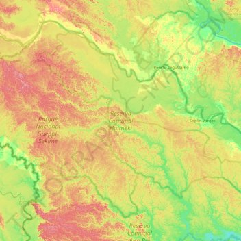
Name: Reserva Comunal Huimeki topographic map, elevation, terrain.
Location: Reserva Comunal Huimeki, Loreto, Perú (-0.67186 -75.23141 -0.07705 -74.42463)
Average elevation: 630 ft
Minimum elevation: 499 ft
Maximum elevation: 810 ft
Make a donation
Gear up for your next adventure:
As an Amazon Associate, this site earns from qualifying purchases at no extra cost to you.
Other topographic maps
Click on a map to view its topography, its elevation and its terrain.
Make a donation
Gear up for your next adventure:
As an Amazon Associate, this site earns from qualifying purchases at no extra cost to you.
Make a donation
Gear up for your next adventure:
As an Amazon Associate, this site earns from qualifying purchases at no extra cost to you.
Orellana
Perú > Loreto > Vargas Guerra
Orellana es una localidad peruana, capital del distrito de Vargas Guerra, ubicado en la provincia del Ucayali en el departamento de Loreto. Se encuentra a una altitud de m s. n. m. Tiene una población de 5191 habitantes en 1993.
Average elevation: 413 ft
Make a donation
Gear up for your next adventure:
As an Amazon Associate, this site earns from qualifying purchases at no extra cost to you.
Make a donation
Gear up for your next adventure:
As an Amazon Associate, this site earns from qualifying purchases at no extra cost to you.
Make a donation
Gear up for your next adventure:
As an Amazon Associate, this site earns from qualifying purchases at no extra cost to you.
Make a donation
Gear up for your next adventure:
As an Amazon Associate, this site earns from qualifying purchases at no extra cost to you.
Make a donation
Gear up for your next adventure:
As an Amazon Associate, this site earns from qualifying purchases at no extra cost to you.
Make a donation
Gear up for your next adventure:
As an Amazon Associate, this site earns from qualifying purchases at no extra cost to you.
Make a donation
Gear up for your next adventure:
As an Amazon Associate, this site earns from qualifying purchases at no extra cost to you.
Make a donation
Gear up for your next adventure:
As an Amazon Associate, this site earns from qualifying purchases at no extra cost to you.
Make a donation
Gear up for your next adventure:
As an Amazon Associate, this site earns from qualifying purchases at no extra cost to you.
Make a donation
Gear up for your next adventure:
As an Amazon Associate, this site earns from qualifying purchases at no extra cost to you.
Make a donation
Gear up for your next adventure:
As an Amazon Associate, this site earns from qualifying purchases at no extra cost to you.
Colonia Angamos
Colonia Angamos es una localidad peruana ubicada en la región Loreto, provincia de Requena, distrito de Yaquerana. Es asimismo capital del distrito de Yaquerana. Se encuentra a una altitud de 104 m s. n. m. Tiene una población de 424 habitantes en 1993.
Average elevation: 335 ft
Make a donation
Gear up for your next adventure:
As an Amazon Associate, this site earns from qualifying purchases at no extra cost to you.
Orellana
Perú > Loreto > Vargas Guerra
Orellana es una localidad peruana ubicada en la región Loreto, provincia de Ucayali, distrito de Vargas Guerra. Es asimismo capital del distrito de Vargas Guerra. Se encuentra a una altitud de m s. n. m. Tiene una población de 5191 habitantes en 1993.
Average elevation: 413 ft