
Make a donation
Gear up for your next adventure:
As an Amazon Associate, this site earns from qualifying purchases at no extra cost to you.
Virginia topographic map
Click on the map to display elevation.
Make a donation
Gear up for your next adventure:
As an Amazon Associate, this site earns from qualifying purchases at no extra cost to you.
Virginia
Virginia's topography is characterized by a diverse landscape that transitions from the Atlantic Coastal Plain in the east to the mountainous regions in the west. The Coastal Plain features flat, low-lying areas that gradually rise to the Piedmont, known for its rolling hills and valleys. Further west, the Blue Ridge Mountains present sharp elevations, with the highest peak, Mount Rogers, reaching 5,729 feet. The Appalachian Ridge and Valley region showcases a series of valleys flanked by mountains, while the Appalachian Plateau in the southwest features rugged terrain interspersed with rivers and forests.
Make a donation
Gear up for your next adventure:
As an Amazon Associate, this site earns from qualifying purchases at no extra cost to you.
About this map
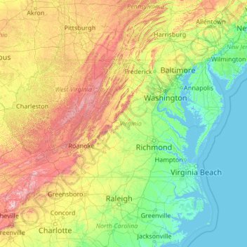
Name: Virginia topographic map, elevation, terrain.
Location: Virginia, United States (36.54079 -83.67537 39.46601 -75.16644)
Average elevation: 814 ft
Minimum elevation: -10 ft
Maximum elevation: 6,253 ft
United States trails, hiking, mountain biking, running and outdoor activities
Make a donation
Gear up for your next adventure:
As an Amazon Associate, this site earns from qualifying purchases at no extra cost to you.
Other topographic maps
Click on a map to view its topography, its elevation and its terrain.
Columbus
United States > Ohio > Franklin County > Columbus
The confluence of the Scioto and Olentangy rivers is just north-west of Downtown Columbus. Several smaller tributaries course through the Columbus metropolitan area, including Alum Creek, Big Walnut Creek, and Darby Creek. Columbus is considered to have relatively flat topography thanks to a large glacier that…
Average elevation: 837 ft
Little Saint James Island
United States > United States Virgin Islands > Saint Thomas - Saint John District
Average elevation: 3 ft
Palm Harbor
United States > Florida > Pinellas County
Palm Harbor is characterized by its unique topography, which features a relatively rare hilly landscape for the region. Unlike much of the surrounding areas in Pinellas County, which are predominantly flat, Palm Harbor includes elevations that can reach up to about 75 feet above sea level. This elevation gives…
Average elevation: 30 ft
Make a donation
Gear up for your next adventure:
As an Amazon Associate, this site earns from qualifying purchases at no extra cost to you.
Boston
United States > Massachusetts > Suffolk County > Boston
Boston has an area of 89.63 sq mi (232.1 km2)—48.4 sq mi (125.4 km2) (54%) of land and41.2 sq mi (106.7 km2) (46%) of water. The city's official elevation, as measured at Logan International Airport, is 19 ft (5.8 m) above sea level. The highest point in Boston is Bellevue Hill at 330 ft (100 m) above sea…
Average elevation: 85 ft
Baltimore
United States > Maryland > Baltimore
Baltimore is in north-central Maryland on the Patapsco River close to where it empties into the Chesapeake Bay. The city is also located on the fall line between the Piedmont Plateau and the Atlantic coastal plain, which divides Baltimore into "lower city" and "upper city". The city's elevation ranges from sea…
Average elevation: 213 ft
Appalachian Mountains
United States > North Carolina > Yancey County
The Appalachian Mountains (French: Appalaches), often called the Appalachians, are a system of mountains in eastern to northeastern North America. The Appalachians first formed roughly 480 million years ago during the Ordovician Period. They once reached elevations similar to those of the Alps and the Rocky…
Average elevation: 4,800 ft
Virginia Beach
United States > Virginia > Virginia Beach
According to the United States Census Bureau, the city has a total area of 497 square miles (1,290 km2), of which 249 square miles (640 km2) is land and 248 square miles (640 km2) (49.9%) is water. It is the largest city in Virginia by total area and third-largest city land area. The average elevation is 12…
Average elevation: 7 ft
Make a donation
Gear up for your next adventure:
As an Amazon Associate, this site earns from qualifying purchases at no extra cost to you.
Port Charlotte
United States > Florida > Charlotte County
Port Charlotte is characterized by a predominantly flat and low-lying terrain, typical of Florida’s coastal landscape. The area features a network of waterways, including the Peace River and Charlotte Harbor, which provide ample opportunities for recreational activities like boating and fishing. Elevations…
Average elevation: 13 ft
Highlands
United States > North Carolina > Macon County > Highlands
Highlands was founded in 1875 after its two founders, Samuel Truman Kelsey and Clinton Carter Hutchinson, drew lines from Chicago to Savannah and from New Orleans to New York City. They felt that the place where these lines met would eventually become a great trading center and commercial crossroads. Highlands…
Average elevation: 3,576 ft
Central Park
United States > New York > New York County > New York
In June 1856, Fernando Wood appointed a "consulting board" of seven people, headed by author Washington Irving, to inspire public confidence in the proposed development. Wood hired military engineer Egbert Ludovicus Viele as the park's chief engineer, tasking him with a topographical survey of the site. The…
Average elevation: 85 ft
Make a donation
Gear up for your next adventure:
As an Amazon Associate, this site earns from qualifying purchases at no extra cost to you.
Make a donation
Gear up for your next adventure:
As an Amazon Associate, this site earns from qualifying purchases at no extra cost to you.
Mount Saint Helens
United States > Washington > Skamania County
The Mount St. Helens major eruption of May 18, 1980 remains the deadliest and most economically destructive volcanic event in U.S. history. Fifty-seven people were killed; 200 homes, 47 bridges, 15 miles (24 km) of railways, and 185 miles (298 km) of highway were destroyed. A massive debris avalanche,…
Average elevation: 6,877 ft
Make a donation
Gear up for your next adventure:
As an Amazon Associate, this site earns from qualifying purchases at no extra cost to you.
Estes Park
United States > Colorado > Larimer County
Estes Park sits at an elevation of 7,522 feet (2,293 m) on the front range of the Rocky Mountains at the eastern entrance of the Rocky Mountain National Park. Its north, south and east extremities border the Roosevelt National Forest. Lumpy Ridge lies immediately north of Estes Park.
Average elevation: 8,343 ft
Make a donation
Gear up for your next adventure:
As an Amazon Associate, this site earns from qualifying purchases at no extra cost to you.
Vail
United States > Colorado > Eagle County
Vail's average elevation is 8,150 feet (2484 m) above sea level. The town has a total area of 4.5 square miles (12 km2), with no lakes (there is, however, at least one pond). Gore Creek flows from east to west through the center of town.
Average elevation: 9,688 ft
Scottsdale
United States > Arizona > Maricopa County > Scottsdale
The city is in the Salt River Valley, or the "Valley of the Sun," in the northern reaches of the Sonoran Desert. Scottsdale, 31 mi (50 km) long and 11.4 mi (18.3 km) wide at its widest point, shares boundaries with many other municipalities and entities. On the west, Scottsdale is bordered by Phoenix, Paradise…
Average elevation: 1,358 ft
Make a donation
Gear up for your next adventure:
As an Amazon Associate, this site earns from qualifying purchases at no extra cost to you.
Make a donation
Gear up for your next adventure:
As an Amazon Associate, this site earns from qualifying purchases at no extra cost to you.
Santa Cruz Mountains
United States > California > Santa Clara County
The Santa Cruz Mountains are a region of great biological diversity, encompassing cool, moist coastal ecosystems as well as warm, dry chaparral. Much of the area in the Santa Cruz mountains is considered temperate rainforest. In valleys and moist ocean-facing slopes some of the southernmost coast redwoods…
Average elevation: 755 ft
Make a donation
Gear up for your next adventure:
As an Amazon Associate, this site earns from qualifying purchases at no extra cost to you.
Crescent City
United States > California > Del Norte County
The topography of the sea floor surrounding Crescent City has the effect of focusing tsunamis. According to researchers at Humboldt State University and the University of Southern California, the city experienced tsunami conditions 31 times between the years 1933 and 2008. Although many of these incidents were…
Average elevation: 102 ft
Indianapolis
United States > Indiana > Indianapolis
Indianapolis is within the Tipton Till Plain, a flat to gently sloping terrain underlain by glacial deposits known as till. The lowest point in the city is about 650 feet (198 m) above mean sea level, with the highest natural elevation at about 900 feet (274 m) above sea level. Few hills or short ridges, known…
Average elevation: 791 ft
Ponte Vedra Beach
United States > Florida > Saint Johns County > Ponte Vedra Beach
Ponte Vedra Beach is characterized by its gently rolling terrain that is primarily flat and lies only about 15 feet above sea level. The landscape is predominantly shaped by coastal dunes and the proximity to the Atlantic Ocean, resulting in sandy beaches interspersed with vegetation typical of barrier island…
Average elevation: 10 ft
Make a donation
Gear up for your next adventure:
As an Amazon Associate, this site earns from qualifying purchases at no extra cost to you.
San Diego
United States > California > San Diego County > San Diego
The climate in San Diego, like most of Southern California, often varies significantly over short geographical distances, resulting in microclimates. In San Diego, this is mostly because of the city's topography (the Bay, and the numerous hills, mountains, and canyons). Frequently, particularly during the "May…
Average elevation: 187 ft
Make a donation
Gear up for your next adventure:
As an Amazon Associate, this site earns from qualifying purchases at no extra cost to you.
Central Park
United States > New York > New York County > New York
In June 1856, Fernando Wood appointed a "consulting board" of seven people, headed by author Washington Irving, to inspire public confidence in the proposed development. Wood hired military engineer Egbert Ludovicus Viele as the park's chief engineer, tasking him with a topographical survey of the site. The…
Average elevation: 85 ft
Appalachian Mountains
United States > North Carolina > Yancey County
The Appalachian Mountains (French: Appalaches), often called the Appalachians, are a system of mountains in eastern to northeastern North America. The Appalachians first formed roughly 480 million years ago during the Ordovician Period. They once reached elevations similar to those of the Alps and the Rocky…
Average elevation: 4,800 ft
Lakewood
United States > Colorado > Jefferson County > Lakewood
Lakewood is located at 39°42′17″N 105°04′53″W / 39.70472°N 105.08139°W / 39.70472; -105.08139 at an elevation of 5,518 feet (1,682 m). Located at the junction of U.S. Route 6 and Colorado State Highway 121 in central Colorado, the city lies immediately west of Denver and 62 miles (100 km)…
Average elevation: 5,633 ft
Make a donation
Gear up for your next adventure:
As an Amazon Associate, this site earns from qualifying purchases at no extra cost to you.
Make a donation
Gear up for your next adventure:
As an Amazon Associate, this site earns from qualifying purchases at no extra cost to you.
Hopeland
United States > Pennsylvania > Lancaster County > Clay Township > Clay
Average elevation: 509 ft
Nokomis
United States > Florida > Sarasota County
Nokomis features a predominantly flat and low-lying terrain characteristic of the coastal region. The elevation in Nokomis rarely exceeds 15 feet above sea level, contributing to its vulnerability to tidal influences and storm surges. The area is interspersed with wetlands and mangroves, particularly near the…
Average elevation: 16 ft
Englewood
United States > Florida > Sarasota County
Englewood features predominantly flat and low-lying terrain typical of the region's coastal landscape. The average elevation here is approximately 15 feet above sea level, which makes the area particularly susceptible to tidal influences and storm surges. The terrain is interspersed with wetlands and…
Average elevation: 10 ft
Make a donation
Gear up for your next adventure:
As an Amazon Associate, this site earns from qualifying purchases at no extra cost to you.
Cathedral Rock
United States > Arizona > Yavapai County
Cathedral Rock is a natural sandstone butte near Sedona, Arizona, United States, and one of the most-photographed sights in the state. The rock formation is located in Coconino National Forest in Yavapai County, about 1 mile (1.6 km) west of State Route 179 (SR 179), and about 2.5 mi (4.0 km) south of the "Y"…
Average elevation: 4,206 ft
San Francisco Bay Area
United States > California > San Francisco
The San Francisco Bay Area is characterized by a diverse and dynamic topography shaped by geological processes over millions of years. This region features a combination of coastal plains, steep hills, and rugged mountains, all influenced by the tectonic activity associated with the nearby San Andreas Fault…
Average elevation: 371 ft
Make a donation
Gear up for your next adventure:
As an Amazon Associate, this site earns from qualifying purchases at no extra cost to you.
Uinta Mountains
The high Uintas were extensively glaciated during the last ice age, and most of the large stream valleys on both the north and south sides of the range held long valley glaciers. However, despite reaching to over 13,500 feet (4,110 m) in elevation, the climate today is sufficiently dry that no glaciers…
Average elevation: 7,753 ft
Rocky Mountains
United States > Wyoming > Teton County
Agriculture and forestry are major industries. Agriculture includes dryland and irrigated farming and livestock grazing. Livestock are frequently moved between high-elevation summer pastures and low-elevation winter pastures, a practice known as transhumance.
Average elevation: 7,520 ft
Make a donation
Gear up for your next adventure:
As an Amazon Associate, this site earns from qualifying purchases at no extra cost to you.
Barn Hill
United States > Connecticut > Greater Bridgeport Planning Region > Monroe
Average elevation: 479 ft
Make a donation
Gear up for your next adventure:
As an Amazon Associate, this site earns from qualifying purchases at no extra cost to you.
Make a donation
Gear up for your next adventure:
As an Amazon Associate, this site earns from qualifying purchases at no extra cost to you.
Make a donation
Gear up for your next adventure:
As an Amazon Associate, this site earns from qualifying purchases at no extra cost to you.
Anna Maria island
United States > Florida > Manatee County
Anna Maria Island features a flat, sandy topography typical of a barrier island on the Gulf Coast. With an average elevation of around 15 feet above sea level, the terrain includes broad beaches, low dunes, and narrow stretches of sandy soil, making it highly vulnerable to storm surges and tidal flooding. The…
Average elevation: 7 ft
East Texas
United States > Pennsylvania > Lehigh County > Lower Macungie Township
Average elevation: 413 ft
Coachella Valley
United States > California > Riverside County > Palm Desert
The area is surrounded on the southwest by the Santa Rosa Mountains, by the San Jacinto Mountains to the west, the Little San Bernardino Mountains to the east and San Gorgonio Mountain to the north. These mountains peak at around 11,000 feet (3,400 m) and tend to average between 5,000 and 7,000 feet (1,500 and…
Average elevation: 236 ft
Make a donation
Gear up for your next adventure:
As an Amazon Associate, this site earns from qualifying purchases at no extra cost to you.
Rogers Pass
United States > Colorado > Gilpin County
Rogers Pass, elevation 11,866 ft (3,617 m), is a mountain pass in the Front Range of central Colorado. The pass crosses the continental divide in the James Peak Wilderness.
Average elevation: 11,312 ft
Make a donation
Gear up for your next adventure:
As an Amazon Associate, this site earns from qualifying purchases at no extra cost to you.
Hoopers Valley Island
United States > New York > Tioga County > Hoopers Valley
Average elevation: 876 ft
Make a donation
Gear up for your next adventure:
As an Amazon Associate, this site earns from qualifying purchases at no extra cost to you.
Atlanta
United States > Georgia > Fulton County
Atlanta (/ætˈlæntə/ at-LAN-tə) is the capital and most populous city of the U.S. state of Georgia. It is the seat of Fulton County, the most populous county in Georgia. With a population of 498,715 living within the city limits, it is the eighth most populous city in the Southeast and 38th most populous…
Average elevation: 935 ft
Make a donation
Gear up for your next adventure:
As an Amazon Associate, this site earns from qualifying purchases at no extra cost to you.
Vinings
United States > Georgia > Cobb County
Vinings features a varied topography characterized by rolling hills and lush, wooded areas that provide a picturesque backdrop to the community. The area is nestled alongside the Chattahoochee River, which contributes to the gentle slopes and valleys that define the landscape. Elevations in Vinings typically…
Average elevation: 922 ft
Black Hills
United States > South Dakota > Pennington County
The Black Hills is an isolated mountain range rising from the Great Plains of North America in western South Dakota and extending into Wyoming, United States. Black Elk Peak, which rises to 7,242 feet (2,207 m), is the range's highest summit. The name of the range in Lakota is Pahá Sápa. It encompasses the…
Average elevation: 6,214 ft
Make a donation
Gear up for your next adventure:
As an Amazon Associate, this site earns from qualifying purchases at no extra cost to you.
Mount Hood
United States > Oregon > Hood River County
Timberline Lodge is a National Historic Landmark located on the southern flank of Mount Hood just below Palmer Glacier, with an elevation of about 6,000 ft (1,800 m).
Average elevation: 8,911 ft
Mauna Kea
United States > Hawaii > Hawaiʻi County
Mauna Kea (/ˌmaʊnə ˈkeɪə/; Hawaiian: [ˈmɐwnə ˈkɛjə]; abbreviation for Mauna a Wākea) is a dormant volcano on the island of Hawaiʻi. Its peak is 4,207.3 m (13,803 ft) above sea level, making it the highest point in the state of Hawaiʻi and second-highest peak of an island on Earth. The peak is…
Average elevation: 13,051 ft
Make a donation
Gear up for your next adventure:
As an Amazon Associate, this site earns from qualifying purchases at no extra cost to you.