Geolocate

Florida topographic map

Click on the map to display elevation.

Florida

Florida is the second smallest municipality of Puerto Rico, with an area of 10 square miles. As the only municipality in Puerto Rico that has its urban area within the northern karst region (sometimes referred as the Northern Karst Hills), it is surrounded by low elevation, red clay and limestone haystack hills known in Caribbean Spanish as mogotes. The southern border of the municipality with Ciales remains one of the least developed areas on the island, due to the ruggedness of the karst. The Río Encantado, a subterranean river, drains this area. Several caves are found in the town, including Román Cave, Miró Cave, and Juana Gómez Cave. Balcon Cave (Cueva Balcón) is located in Florida.

Wikipedia (CC-BY-SA 3.0)

About this map

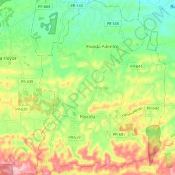
Name: Florida topographic map, elevation, terrain.

Location: Florida, Puerto Rico, 00650, United States (18.33725 -66.59163 18.41400 -66.53066)

Average elevation: 656 ft

Minimum elevation: 318 ft

Maximum elevation: 1,145 ft

Puerto Rico trails, hiking, mountain biking, running and outdoor activities

Other topographic maps

Click on a map to view its topography, its elevation and its terrain.

Ponce

United States > Puerto Rico > Ponce

Elevations include Cerro de Punta at 4,390 feet (1,338 m), the highest in Puerto Rico, located in Barrio Anón in the territory of the municipality of Ponce. Mount Jayuya, at 4,314 feet (1,315 m) is located on the boundary between Barrio Anón and Barrio Saliente in Jayuya. Cerro Maravilla, at nearly 3,970…

Average elevation: 620 ft

Cayo Santiago

United States > Puerto Rico

Average elevation: 0 ft

Sector Palo Seco

United States > Puerto Rico > Adjuntas

Average elevation: 1,972 ft

Sector Lolo Forte

United States > Puerto Rico > Camuy > Camuy

Average elevation: 144 ft

Cerro La Peña

United States > Puerto Rico > Bayamón

Average elevation: 1,076 ft

Reparto Aguiar

United States > Puerto Rico > Aguadilla

Average elevation: 210 ft

Cerro Santa Ana

United States > Puerto Rico > San Lorenzo

Average elevation: 538 ft

Sector Marino

United States > Puerto Rico > Bayamón

Average elevation: 1,342 ft

El Centro

United States > Puerto Rico > Quebradillas

Average elevation: 476 ft

Cerro Mariquita

United States > Puerto Rico > Cabo Rojo

Average elevation: 397 ft

Piedra Blanca

United States > Puerto Rico > San Lorenzo

Average elevation: 574 ft

Cerro La Silla

United States > Puerto Rico > Isabela

Average elevation: 728 ft

Plato Colmar

United States > Puerto Rico > Sabana Grande

Average elevation: 1,076 ft

Cerro Avispa

United States > Puerto Rico > Adjuntas

Average elevation: 1,775 ft

Cerro Avispa

United States > Puerto Rico > Morovis

Average elevation: 1,010 ft

Cerro Santa Ana

United States > Puerto Rico > Coamo

Average elevation: 735 ft

Cerro Santa Elena

United States > Puerto Rico > Yabucoa

Average elevation: 791 ft

Cerro de los Cielos

United States > Puerto Rico > Salinas

Average elevation: 1,007 ft

Cerro Santo Domingo

United States > Puerto Rico > Lares

Average elevation: 1,880 ft

La Piedra

United States > Puerto Rico > Cayey

Average elevation: 1,923 ft

Cerro Gonzalo

United States > Puerto Rico > Aguadilla

Average elevation: 190 ft

Yauco

United States > Puerto Rico > Yauco

Average elevation: 338 ft

Cayo Chiva

United States > Puerto Rico

Average elevation: 16 ft

Aguadilla

United States > Puerto Rico > Aguadilla > Aguadilla

Average elevation: 200 ft

Adjuntas

United States > Puerto Rico > Adjuntas

Adjuntas features a tropical rainforest climate that borders on a subtropical highland climate. While the town technically features a tropical rainforest climate, due to its high elevation, the climate is noticeably cooler than the norm for this climate category. Summers are warm (83°-85 °F) in the daytime…

Average elevation: 2,257 ft

Cabo Rojo

United States > Puerto Rico > Cabo Rojo

Average elevation: 148 ft

Cerro de Punta

United States > Puerto Rico > Ponce

The mountain is part of the Cordillera Central and is located on the border between the municipalities of Jayuya and Ponce. The access road to the point closest to the highest elevation is from the municipality of Jayuya. It is part of the Toro Negro Forest Reserve, and it has been described as "an alpine…

Average elevation: 3,350 ft

Isabel Segunda

United States > Puerto Rico > Vieques

Average elevation: 79 ft

Aguas Buenas

United States > Puerto Rico > Aguas Buenas

Average elevation: 902 ft

Lares

United States > Puerto Rico > Lares > Lares

Average elevation: 1,214 ft

Las Piedras

United States > Puerto Rico > Las Piedras > Las Piedras

Average elevation: 423 ft

Humacao

United States > Puerto Rico > Humacao > Humacao

Humacao is located in the southeast coast of Puerto Rico. It is bordered by the municipalities of Naguabo to the north, Yabucoa to the south, and Las Piedras to the west. The Atlantic Ocean borders the city in the east. Humacao is located in the region of the Eastern Coastal Plains, with most of its territory…

Average elevation: 256 ft

Ciales

United States > Puerto Rico > Ciales

Average elevation: 620 ft

Corozal

United States > Puerto Rico > Corozal > Corozal

Average elevation: 568 ft

Playa Mar Chiquita

United States > Puerto Rico > Manatí

Average elevation: 33 ft

San Lorenzo

United States > Puerto Rico > San Lorenzo > San Lorenzo

Average elevation: 512 ft

Vega Baja

United States > Puerto Rico > Vega Baja > Vega Baja

Average elevation: 115 ft

Aguada

United States > Puerto Rico > Aguada > Aguada

Average elevation: 102 ft

Cerro Prieto

United States > Puerto Rico > Utuado

Average elevation: 2,133 ft

East Ridge

United States > Puerto Rico > Mayagüez

Average elevation: 30 ft

Gear up for your next adventure:

📦Dry Bags Set - Waterproof storage for electronics and clothes
😴Insulated Sleeping Pads - Compact and warm pads for high-elevation camping
👓Polarized Sunglasses - Outdoor sunglasses for glare reduction
🪶Camp Gear Gift Set - Perfect gift bundle for outdoor fans
🧭Pro Hiking Compasses - High-accuracy liquid-filled compasses for topographic orientation

As an Amazon Associate, this site earns from qualifying purchases at no extra cost to you.