
Rajaund topographic map
Click on the map to display elevation.
About this map
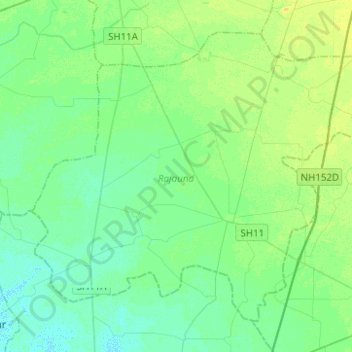
Name: Rajaund topographic map, elevation, terrain.
Location: Rajaund, Kaithal, Haryana, India (29.51469 76.34528 29.69208 76.59371)
Average elevation: 768 ft
Minimum elevation: 748 ft
Maximum elevation: 801 ft
Other topographic maps
Click on a map to view its topography, its elevation and its terrain.
Surajkund
In the Aravalli hill ranges, which spreads over Delhi and Haryana, where the Surajkund and the Anagpur Dam are located, ancient Stone Age relics have been revealed. The Aravallis, which strike out in two directions from Delhi exhibits a topography of low and rugged hills. The stratigraphy in the area is…
Average elevation: 755 ft
Narnaul
Narnaul is located at 28°02′N 76°07′E / 28.04°N 76.11°E / 28.04; 76.11. It has an average elevation of 300 meters (977 feet). The district is rich in mineral resources such as iron ore, copper ore, beryl, tourmaline, muscovite, biotite, albite, calcite, and quartz.
Average elevation: 1,043 ft