
Cave Creek topographic map
Interactive map
Click on the map to display elevation.
Cave Creek
Cave Creek is a town in the Sonoran Desert. It sits in northern Maricopa County on the northern edge of Paradise Valley, with mountains rising to the north that eventually connect with the New River Mountains and the Black Hills. It is 33 miles (53 km) north of downtown Phoenix, although the Phoenix city limits extend north to Cave Creek's southern border. The town is bordered to the east by the town of Carefree, to the west by unincorporated New River, and to the north by Tonto National Forest. Elephant Mountain rises to an elevation of 3,926 feet (1,197 m) in the northernmost part of the town. Local landmark Black Mountain, elevation 3,398 feet (1,036 m), is in the southern part of town on the border with Carefree.
About this map
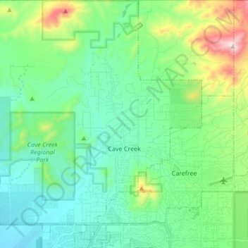
Name: Cave Creek topographic map, elevation, terrain.
Location: Cave Creek, Maricopa County, Arizona, United States (33.78831 -112.03051 33.90062 -111.90861)
Average elevation: 2,438 ft
Minimum elevation: 1,821 ft
Maximum elevation: 4,472 ft
Maricopa County trails, hiking, mountain biking, running and outdoor activities
Other topographic maps
Click on a map to view its topography, its elevation and its terrain.
Phoenix
United States > Arizona > Maricopa County > Phoenix
Phoenix is in the south-central portion of Arizona; about halfway between Tucson to the southeast and Flagstaff to the north, in the southwestern United States. By car, the city is approximately 150 miles (240 kilometers) north of the US–Mexico border at Sonoyta and 180 mi (290 km) north of the border at…
Average elevation: 1,207 ft
Cave Creek Park - Thunderbird
United States > Arizona > Maricopa County > Phoenix
Average elevation: 1,316 ft
White Tank Mountain Regional Park
United States > Arizona > Maricopa County
Average elevation: 2,188 ft
Salt River
United States > Arizona > Maricopa County > Scottsdale
Salt River is a populated place situated in Maricopa County, Arizona, United States. It has an estimated elevation of 1,220 feet (370 m) above sea level. It is located on the Salt River Pima–Maricopa Indian Community.
Average elevation: 1,220 ft
Sundad
United States > Arizona > Maricopa County
Sundad is an unincorporated area in the far west of Maricopa County, Arizona, United States, along the border of Yuma County. It has an estimated elevation of 965 feet (294 m) above sea level. It is located north of Agua Caliente and east of Sacation Flats.
Average elevation: 984 ft
Camelback Mountain
United States > Arizona > Maricopa County > Phoenix
Efforts to protect Camelback Mountain as a natural preserve began in the early 1910s. However, by the 1960s, nearly all of the area had been sold to private interests. Federal and state authorities attempted to stop development above the one thousand and six hundred feet level. They failed to halt development…
Average elevation: 1,516 ft
Anthem
United States > Arizona > Maricopa County
Anthem is built on 5,856 acres (9.2 sq mi) at the base of Daisy Mountain and Gavilan Peak in northern Maricopa County. The CDP portion of Anthem has an area of 7.9 square miles (20 km2). The community's elevation ranges from 1,760 to 2,428 feet (536 to 740 m), with an average elevation of 1,863 feet (568 m).…
Average elevation: 1,896 ft
Pinnacle Peak
United States > Arizona > Maricopa County > Scottsdale
Pinnacle Peak is a granite summit located in Scottsdale, Arizona. The peak rises to an elevation of 3,169 feet (966 m). It is located within the 150-acre (61 ha) Pinnacle Peak Park, operated by the City of Scottsdale Park District. Part of the Sonoran Desert, the park is home to a variety of native desert…
Average elevation: 2,470 ft
Estrella Mountain Regional Park
United States > Arizona > Maricopa County > Avondale
Average elevation: 1,302 ft
Komatke
United States > Arizona > Maricopa County > Gila Crossing
Saint John the Baptist Parish Laveen, the Saint Johns Mission, is in Komatke. The name is taken from the mission school founded by the Franciscans in 1894. It has an estimated elevation of 1,030 feet (310 m) above sea level.
Average elevation: 1,099 ft
Desert Botanical Garden
United States > Arizona > Maricopa County > Phoenix
Average elevation: 1,276 ft
Tempe
United States > Arizona > Maricopa County > Tempe
Tempe is generally flat, except for Hayden Butte (generally known as A-Mountain for Arizona State University's "A" logo located on its south face), located next to Sun Devil Stadium, Twin Buttes and Bell Butte on the western edge of Tempe, and Papago Park northwest of Tempe, inside Phoenix. Elevation ranges…
Average elevation: 1,266 ft
Sentinel
United States > Arizona > Maricopa County
Sentinel is an unincorporated community in Maricopa County, Arizona, United States. It has an estimated elevation of 692 feet (211 m) above sea level.
Average elevation: 699 ft