Mercer County topographic map
Interactive map
Click on the map to display elevation.
About this map
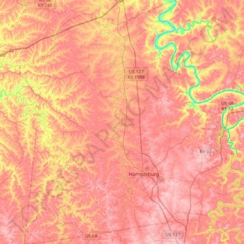
Name: Mercer County topographic map, elevation, terrain.
Location: Mercer County, Kentucky, United States (37.67871 -85.03115 37.96998 -84.68808)
Average elevation: 833 ft
Minimum elevation: 502 ft
Maximum elevation: 994 ft
Other topographic maps
Click on a map to view its topography, its elevation and its terrain.
Louisville
United States > Kentucky > Jefferson County
Louisville, Jefferson County, Kentucky, United States
Average elevation: 617 ft
Somerset
United States > Kentucky > Pulaski County
Somerset, Pulaski County, Kentucky, 42503, United States
Average elevation: 968 ft
Bowling Green
United States > Kentucky > Warren County
Bowling Green, Warren County, Kentucky, 42101, United States
Average elevation: 554 ft
Paducah
United States > Kentucky > McCracken County
Paducah, McCracken County, Kentucky, United States
Average elevation: 354 ft
Taylor Mill
United States > Kentucky > Kenton County
Taylor Mill, Kenton County, Kentucky, 41015, United States
Average elevation: 692 ft
Garrard County
Garrard County, Kentucky, United States
Average elevation: 915 ft
Owensboro
United States > Kentucky > Daviess County
Owensboro, Daviess County, Kentucky, United States
Average elevation: 404 ft
Lexington
United States > Kentucky > Lexington
Lexington, Fayette County, Kentucky, 40508, United States
Average elevation: 935 ft
Fort Knox
United States > Kentucky > Fort Knox
Fort Knox, Hardin County, Kentucky, 40121, United States
Average elevation: 682 ft
Frankfort
United States > Kentucky > Franklin County
Frankfort, Franklin County, Kentucky, United States
Average elevation: 709 ft
Land Between the Lakes National Recreation Area
United States > Kentucky > Trigg County
Land Between the Lakes National Recreation Area, Trigg County, Kentucky, United States
Average elevation: 479 ft
Radcliffe
United States > Kentucky > Fayette County > Lexington
Radcliffe, Radcliff Marlboro, Lexington, Fayette County, Kentucky, 40505, United States
Average elevation: 978 ft
Liberty
United States > Kentucky > Casey County
Liberty, Casey County, Kentucky, United States
Average elevation: 906 ft
McHenry
United States > Kentucky > Ohio County
McHenry, Ohio County, Kentucky, 42354, United States
Average elevation: 466 ft
Tollesboro
United States > Kentucky > Lewis County
Tollesboro, Lewis County, Kentucky, 41189, United States
Average elevation: 784 ft
Cordell
United States > Kentucky > Lawrence County
Cordell, Lawrence County, Kentucky, United States
Average elevation: 906 ft
Breckinridge County
Breckinridge County, Kentucky, United States
Average elevation: 627 ft
Hardinsburg
United States > Kentucky > Breckinridge County
Hardinsburg, Breckinridge County, Kentucky, 40143, United States
Average elevation: 673 ft
Guthrie
United States > Kentucky > Todd County
Guthrie, Todd County, Kentucky, United States
Average elevation: 564 ft
Southville
United States > Kentucky > Shelby County
Southville, Shelby County, Kentucky, United States
Average elevation: 758 ft
Shakertown
United States > Kentucky > Mercer County
Shakertown, Mercer County, Kentucky, United States
Average elevation: 827 ft
Straw
United States > Kentucky > Edmonson County
Straw, Edmonson County, Kentucky, 42259, United States
Average elevation: 738 ft
Vine Grove
United States > Kentucky > Hardin County
Vine Grove, Hardin County, Kentucky, United States
Average elevation: 715 ft
Wickliffe
United States > Kentucky > Ballard County
Wickliffe, Ballard County, Kentucky, United States
Average elevation: 361 ft
Francisville
United States > Kentucky > Boone County
Francisville, Boone County, Kentucky, 41048, United States
Average elevation: 751 ft
Lebanon Junction
United States > Kentucky > Bullitt County
Lebanon Junction, Bullitt County, Kentucky, United States
Average elevation: 472 ft
Lexington
United States > Kentucky > Fayette County
Lexington, Fayette County, Kentucky, United States
Average elevation: 922 ft
Bradley
United States > Kentucky > Magoffin County
Bradley, Magoffin County, Kentucky, United States
Average elevation: 1,073 ft
Buzzard Roost
United States > Kentucky > Calloway County
Buzzard Roost, Calloway County, Kentucky, United States
Average elevation: 459 ft
Springfield
United States > Kentucky > Washington County
Springfield, Washington County, Kentucky, United States
Average elevation: 797 ft
Daviess County
Daviess County, Kentucky, United States
Average elevation: 427 ft
Fayette County
Fayette County, Kentucky, United States
Average elevation: 925 ft
Ezel
United States > Kentucky > Morgan County
Ezel, Morgan County, Kentucky, 41425, United States
Average elevation: 958 ft
Knoxville
United States > Kentucky > Pendleton County
Knoxville, Pendleton County, Kentucky, United States
Average elevation: 823 ft
Sullivan
United States > Kentucky > Union County
Sullivan, Union County, Kentucky, 42460, United States
Average elevation: 387 ft
Van Cleave
United States > Kentucky > Calloway County
Van Cleave, Calloway County, Kentucky, 42091, United States
Average elevation: 528 ft
Gilbertsville
United States > Kentucky > Marshall County
Gilbertsville, Marshall County, Kentucky, United States
Average elevation: 341 ft
Vealsburg
United States > Kentucky > Graves County
Vealsburg, Graves County, Kentucky, 42040, United States
Average elevation: 528 ft
Carrollton
United States > Kentucky > Carroll County
Carrollton, Carroll County, Kentucky, United States
Average elevation: 558 ft
Cumberland Falls
United States > Kentucky > McCreary County
Cumberland Falls, McCreary County, Kentucky, 42634, United States
Average elevation: 1,024 ft
Madisonville
United States > Kentucky > Hopkins County
Madisonville, Hopkins County, Kentucky, 42431, United States
Average elevation: 446 ft
Timsley
United States > Kentucky > Bell County
Timsley, Bell County, Kentucky, 40939, United States
Average elevation: 1,358 ft
Southgate
United States > Kentucky > Campbell County
Southgate, Campbell County, Kentucky, United States
Average elevation: 696 ft
Jefferson County
Jefferson County, Kentucky, United States
Average elevation: 604 ft
Hickman County
Hickman County, Kentucky, United States
Average elevation: 381 ft
Frenchburg
United States > Kentucky > Menifee County
Frenchburg, Menifee County, Kentucky, United States
Average elevation: 1,083 ft
Kentucky River
Kentucky River, Kentucky, United States
Average elevation: 853 ft