Geolocate
Thank you for supporting this site ❤️
Make a donation

Zambales topographic map

Interactive map

Click on the map to display elevation.

About this map

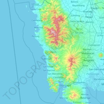
Name: Zambales topographic map, elevation, terrain.

Location: Zambales, Central Luzon, Philippines (14.60506 119.64561 15.87406 120.44916)

Average elevation: 407 ft

Minimum elevation: -3 ft

Maximum elevation: 6,572 ft

Other topographic maps

Click on a map to view its topography, its elevation and its terrain.

Imus

Philippines > Cavite > Imus

Average elevation: 102 ft

Baguio

Philippines

In 1903, Filipinos, Japanese and Chinese workers were hired to build Kennon Road, the first road directly connecting Baguio with the lowlands of La Union and Pangasinan. Before this, the only road to Benguet was Naguilian Road, and it was largely a horse trail at higher elevations. Camp John Hay was…

Average elevation: 2,890 ft

Quezon City

Philippines

Quezon City is characterized by a diverse topography that features a mix of flatlands, rolling hills, and elevated areas, particularly in the eastern and northern parts of the city. The elevation generally ranges from about 25 to 300 feet above sea level, with higher elevations found in areas like the La Mesa…

Average elevation: 187 ft

San Mateo

Philippines > Rizal > San Mateo

San Mateo, located in the province of Rizal in the Calabarzon region, features a diverse topography characterized by a mix of rolling hills and mountainous terrain. The elevation in the area varies significantly, ranging from the relatively low-lying plains at around 16 feet (5 meters) above sea level, up to…

Average elevation: 223 ft

Cebu City

Philippines > Cebu > Cebu City

Average elevation: 459 ft

Mariveles

Philippines > Bataan > Mariveles

Mariveles features a diverse and dynamic topography characterized by its mountainous terrain and coastal landscapes. The region is dominated by the prominent Mount Mariveles, a stratovolcano that reaches an elevation of approximately 4,531 feet (1,388 meters) at its highest point. The mountain is part of a…

Average elevation: 272 ft

Tagaytay

Philippines > Cavite

It is one of the country's most popular destinations for domestic tourism because of its scenery and cooler climate provided by its altitude. Tagaytay overlooks Taal Lake in Batangas and provides views of Taal Volcano Island in the middle of the lake through various vantage points situated in the city.

Average elevation: 751 ft

Binangonan

Philippines > Rizal

Average elevation: 69 ft

Solsona

Philippines > Ilocos Norte

Average elevation: 207 ft

Martilo

Philippines > Negros Oriental > La Libertad

Average elevation: 128 ft

Kilometer 6

Philippines > Benguet > Tadiangan

Average elevation: 3,514 ft

Capucnasan

Philippines > Camarines Sur

Average elevation: 59 ft

Alaguisoc

Philippines > Guimaras > Jordan

Average elevation: 410 ft

Camp 3

Philippines > Benguet > Tuba

Average elevation: 2,785 ft

Nagba

Philippines > Capiz > Cuartero

Average elevation: 75 ft

Inclanay Dam

Philippines > Oriental Mindoro > Inclanay > Pansulan

Average elevation: 95 ft

Cadaclan

Philippines > La Union > San Fernando

Average elevation: 315 ft

Tinadtaran

Philippines > Guimaras > Buenavista

Average elevation: 213 ft

Bacolor

Philippines > Pampanga

Average elevation: 26 ft

Kayquit III

Philippines > Cavite > Indang

Average elevation: 1,224 ft

Tantangan

Philippines > South Cotabato

Average elevation: 177 ft

Freedom Park

Philippines > Marikina

Average elevation: 43 ft

La Medalla

Philippines > Camarines Sur

Average elevation: 138 ft

Hamlet

Philippines > Bataan > Bagac

Average elevation: 184 ft

Bancasi

Philippines > Butuan

Average elevation: 56 ft

Barbo

Philippines > Eastern Samar

Average elevation: 26 ft

Mainit

Philippines > Surigao Del Norte

Average elevation: 269 ft

San Antonio

Philippines > Quezon > Guinayangan

Average elevation: 315 ft

Tahao Road

Philippines > Albay > Malobago

Average elevation: 157 ft

Villa Paz

Philippines > Palawan > El Nido

Average elevation: 39 ft

San Pablo

Philippines > Pampanga > Guagua

Average elevation: 10 ft

Panungyan II

Philippines > Cavite > Mendez

Average elevation: 1,594 ft

Malabo

Philippines > Negros Oriental

Average elevation: 1,824 ft

Agcogon

Philippines > Romblon > San Jose

Average elevation: 131 ft

Dilasag

Philippines > Aurora

Average elevation: 98 ft

Alcate

Philippines > Oriental Mindoro

Average elevation: 184 ft

Pulang-Bato

Philippines > Batangas

Average elevation: 72 ft

Matubog

Philippines > Tarlac > Camiling

Average elevation: 72 ft

Peñafrancia

Philippines > Albay > Daraga

Average elevation: 289 ft

Agricula

Philippines > Antique > San Remigio

Average elevation: 1,227 ft

Pooc II

Philippines > Cavite

Average elevation: 1,148 ft

Calabuso

Philippines > Cavite > Tagaytay

Average elevation: 1,355 ft

Mayag River

Philippines > Surigao Del Norte > Cantugas

Average elevation: 597 ft

Tanza

Philippines > Marinduque > Boac

Average elevation: 62 ft

San Fernando

Philippines > Nueva Vizcaya

Average elevation: 1,243 ft

Iguig

Philippines > Cagayan

Average elevation: 98 ft

Silway River

Philippines > South Cotabato > Polomolok

Average elevation: 843 ft

Dupax del Sur

Philippines > Nueva Vizcaya

Average elevation: 1,401 ft

Cabunagan

Philippines > Mountain Province > Balaoa

Average elevation: 4,524 ft

Caballo Island

Philippines > Cavite > Cavite City

Caballo Island (which means "Horse Island" in Spanish) is a bluff, rocky island located at the entrance to Manila Bay in the Philippines. It is about 1.2 km (0.75 mi) long with the highest elevation at 381 feet high. Caballo, along with the larger Corregidor (2 km to the north), divides the entrance to the bay…

Average elevation: 0 ft

Maligaya

Philippines > Bataan > Mariveles

Average elevation: 440 ft

Compostela

Philippines > Davao de Oro

Average elevation: 256 ft

Balcon Maravilla

Philippines > Guimaras > Jordan

Average elevation: 256 ft

Constancia

Philippines > Guimaras > San Lorenzo

Average elevation: 351 ft

Poblacion

Philippines > Zamboanga Sibugay > Naga

Average elevation: 72 ft

Bayho

Philippines > Northern Samar

Average elevation: 269 ft

Mount Talamitam

Philippines > Batangas > Nasugbu

Average elevation: 1,224 ft

Upi

Philippines > Isabela

Average elevation: 154 ft

Bessang Pass

Philippines > Ilocos Sur

Average elevation: 4,518 ft

Bagtic

Philippines > Negros Oriental > La Libertad

Average elevation: 1,509 ft

Goldfield

Philippines > Benguet > Itogon

Average elevation: 2,969 ft

Lingayen

Philippines > Pangasinan

Average elevation: 13 ft

Abuyog

Philippines > Sorsogon

Average elevation: 43 ft

Ampucao

Philippines > Benguet

Average elevation: 4,321 ft

EM's Barrio

Philippines > Albay > Legazpi

Average elevation: 115 ft

Balite I

Philippines > Cavite

Average elevation: 1,184 ft

Sorsogon City

Philippines > Sorsogon

Sorsogon City covers a land area of 31,292 hectares (120.82 sq mi). It is at the southernmost tip of the Bicol Peninsula and of Luzon Island. The city is bounded by Castilla in the west, Manito in the northwest, Albay Gulf in the north, Prieto Diaz in the east, Gubat in the southeast, Casiguran in the…

Average elevation: 292 ft

Dolho

Philippines > Leyte > Bato

Average elevation: 13 ft

Tagudin

Philippines > Ilocos Sur

Average elevation: 79 ft

Sinocalan River

Philippines > Pangasinan > San Manuel

Average elevation: 1,161 ft

Tambang

Philippines > Camarines Sur > Tinambac

Average elevation: 118 ft

Malig

Philippines > Davao Oriental > Lupon

Average elevation: 1,168 ft

Taguanao

Philippines > Misamis Occidental

Average elevation: 489 ft

Camp 7

Philippines > Cebu

Average elevation: 1,621 ft

Bagumbayan

Philippines > Negros Occidental > Valladolid

Average elevation: 10 ft

Binaton

Philippines > Davao del Sur > Digos

Average elevation: 1,381 ft

Bulacnin

Philippines > Batangas > Lipa

Average elevation: 1,053 ft

Batangas Bay

Philippines > Batangas > Bauan

Average elevation: 0 ft

Katangawan

Philippines > General Santos

Average elevation: 131 ft

Daet River

Philippines > Camarines Norte > Daet > Bibirao

Average elevation: 62 ft

Sampaga

Philippines > Batangas > Batangas City

Average elevation: 213 ft

Natividad

Philippines > Laguna > Pangil

Average elevation: 230 ft

Cabanatuan

Philippines > Nueva Ecija

Average elevation: 154 ft

San Gabriel

Philippines > La Union

Average elevation: 430 ft

Balabagan

Philippines > Lanao del Sur

Average elevation: 154 ft

Iruhin West

Philippines > Cavite > Tagaytay

Average elevation: 1,634 ft

Tagdangua

Philippines > Davao de Oro

Average elevation: 118 ft

Tarlac River

Philippines > Tarlac

Average elevation: 141 ft

Buenavista

Philippines > Agusan del Norte

Average elevation: 39 ft

Lumintao

Philippines > Bukidnon > Quezon

Average elevation: 1,217 ft

Gohang

Philippines > Ifugao > Banaue

Average elevation: 3,993 ft

Balongay

Philippines > Camarines Sur

Average elevation: 7 ft

Civoleg

Philippines > Misamis Oriental > Gingoog

Average elevation: 3,553 ft

Pangi

Philippines > Siquijor > Siquijor

Average elevation: 207 ft

Ilihan

Philippines > Southern Leyte > Macrohon

Average elevation: 505 ft

New Guinsaugon

Philippines > Southern Leyte

Average elevation: 92 ft

Sinocalan River

Philippines > Pangasinan > Santa Barbara

Average elevation: 20 ft

Lataban

Philippines > Cebu

Average elevation: 331 ft