
Montezuma County topographic map
Interactive map
Click on the map to display elevation.
Montezuma County
A large county, roughly 1/3 of its area is tribal land, 1/3 is federal land (administered by the National Park Service, the United States Forest Service and the Bureau of Land Management), and 1/3 private or state/county land. It is also varied topographically, ranging in elevation from about 6,000 feet (1,800 m) to more than 13,200 feet (4,000 m), and from high Colorado Plateau desert to alpine tundra. The county has the second largest reservoir in Colorado, McPhee Reservoir, many other large reservoirs, and hundreds of private lakes and ponds. Much of the county is irrigated cropland, and it produces fruit, large numbers of cattle and sheep, and beans. It is served by U.S. Highways 160 and 491 (formerly US 666), and by Cortez Municipal Airport. It has no rail service, although both Mancos and Dolores were established as railroad towns in the 1890s.
About this map
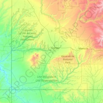
Name: Montezuma County topographic map, elevation, terrain.
Location: Montezuma County, Colorado, United States (36.99897 -109.04593 37.63959 -107.96992)
Average elevation: 6,647 ft
Minimum elevation: 4,495 ft
Maximum elevation: 12,999 ft
Colorado trails, hiking, mountain biking, running and outdoor activities
Other topographic maps
Click on a map to view its topography, its elevation and its terrain.
Denver
United States > Colorado > Denver County > Denver
Denver, situated at an elevation of 5,280 feet (1,609 meters), is renowned as the "Mile High City." It is located in the South Platte River Valley, just east of the Rocky Mountains' foothills. The city's topography features a gently sloping landscape characterized by rolling hills and wide valleys,…
Average elevation: 5,525 ft
Telluride
United States > Colorado > San Miguel County
Telluride has an elevation of 8,750 feet (2,670 m) in an isolated spot in Southwest Colorado. From the west, Colorado Route 145 is the most common way into Telluride; two other passes enter the town, Imogene Pass and Black Bear Pass.
Average elevation: 10,253 ft
Colorado Springs
United States > Colorado > El Paso County
Colorado Springs boasts a diverse and striking topography characterized by its high elevation and mountainous terrain. Nestled at approximately 6,035 feet (1,839 meters) above sea level, the city is flanked by the majestic Pikes Peak, which rises dramatically to 14,115 feet (4,302 meters), forming part of the…
Average elevation: 7,388 ft
Pueblo
United States > Colorado > Pueblo County
Pueblo has a steppe climate (Köppen BSk), with four distinct seasons. Winter days are usually mild, but the high does not surpass freezing on an average 15.3 days per year, and lows fall to 0 °F (−18 °C) or below on 7.8 nights. Snowfall usually falls in light amounts, and due to the high altitude, and the…
Average elevation: 4,879 ft
Monument
United States > Colorado > Monument
Monument is situated at an elevation of approximately 7,000 feet (2,134 meters) within the Front Range of the Rocky Mountains, creating a diverse topography that is both striking and varied. The town is characterized by rolling hills and flat terrain in the valley, contrasted by the rugged foothills of the…
Average elevation: 6,998 ft
Rocky Mountain National Park
United States > Colorado > Larimer County
Rocky Mountain National Park is one of the highest national parks in the nation, with elevations from 7,860 to 14,259 feet (2,396 to 4,346 m), the highest point of which is Longs Peak. Trail Ridge Road is the highest paved through-road in the country, with a peak elevation of 12,183 feet (3,713 m). Sixty…
Average elevation: 10,082 ft
Gunnison County
Gunnison County is a county located in the U.S. state of Colorado. As of the 2020 census, the population was 16,918. The county seat is Gunnison. The county was named for John W. Gunnison, a United States Army officer and captain in the Army Topographical Engineers, who surveyed for the transcontinental…
Average elevation: 9,488 ft
Denver
Denver is characterized by its diverse topography that combines both high plains and mountain ranges. The city itself sits at an elevation of 5,280 feet (1,609 meters), marking it as the "Mile High City." To the east, the landscape transitions into the High Plains, which extend toward the Kansas border,…
Average elevation: 5,525 ft
Longmont
United States > Colorado > Boulder County
The elevation at City Hall is 4,978 feet (1,517 m) above sea level. St. Vrain Creek, a tributary of the South Platte River, flows through the city just south of the city center.
Average elevation: 5,033 ft
Woodland Park
United States > Colorado > Teller County
The area is characterized by the abundance of large granite rocks and alpine meadows, as well as its consistently high elevation ranging between 8,200 and 10,000 feet above sea level. The climate is considered arid which causes the surrounding forests to become very dry, posing a significant fire threat in…
Average elevation: 8,701 ft
Durango
United States > Colorado > La Plata County
Durango is set within a striking and diverse topography characterized by its elevation of 6,512 feet above sea level and its position in the Animas River Valley. The city lies at the foothills of the rugged La Plata Mountains to the west and is flanked by the San Juan Mountains to the north and east. This…
Average elevation: 7,093 ft
Evergreen
United States > Colorado > Jefferson County > Evergreen
Evergreen sits at an elevation of 7,220 feet (2,200 m) in the Rocky Mountains, 19 miles west of Denver, Colorado. Its addresses are oriented according to the Street_system_of_Denver.
Average elevation: 7,575 ft
Trinidad
United States > Colorado > Las Animas County
Trinidad is situated in the Purgatoire River valley in far southern Colorado at an elevation of 6,025 ft (1,836 m). The city lies 13 mi north of the New Mexico border. On the northern end of the town is Simpson's Rest, a prominent bluff named for early resident George Simpson, who is buried atop it. North…
Average elevation: 6,257 ft
Castle Rock
United States > Colorado > Douglas County
Castle Rock is located at 39°22′20″N 104°51′22″W / 39.37222°N 104.85611°W / 39.37222; -104.85611 (39.372212, −104.856090) at an elevation of 6,224 feet (1,897 m). Castle Rock is in central Colorado at the junction of Interstate 25 and State Highway 86, 28 mi (45 km) south of downtown…
Average elevation: 6,404 ft
Breckenridge
United States > Colorado > Summit County
At the 2020 United States Census, the town had a total area of 6.047 square miles (15.661 km2), all of it land. The ski area has a total area of 2,880 acres (11.7 km2) of land. The elevation of Breckenridge is 9,600 feet (2,900 m) above sea level.
Average elevation: 10,079 ft
Fort Collins
United States > Colorado > Larimer County
Fort Collins is situated at an elevation of approximately 5,003 feet (1,524 meters) above sea level, nestled at the base of the Rocky Mountains in northern Colorado. The city features a varied topography characterized by gently rolling plains that gradually rise to foothills, creating a picturesque backdrop.…
Average elevation: 5,079 ft
Boulder
United States > Colorado > Boulder County
Boulder is located at the base of the foothills of the Rocky Mountains, at an elevation of 5,430 feet (1,655 m) above sea level. Boulder is 25 miles (40 km) northwest of the Colorado state capital of Denver. It is home of the main campus of the University of Colorado, the state's largest university.
Average elevation: 5,860 ft
Palmer Lake
United States > Colorado > El Paso County
The town marks the top of the Palmer Divide, a ridge running from Palmer Lake eastward which separates the Arkansas River drainage to the south from the Platte River drainage to the north. The highest point of the divide is about 7,700 feet (2,300 m) above sea level at Vollmer Hill located in the Black Forest.…
Average elevation: 7,552 ft
Pikes Peak
United States > Colorado > El Paso County
Soils on Pikes Peak above the timberline (approximately 12,000 ft or 3,700 m) are classified as Cirque land. Forests at lower altitudes mostly lie over the brown stony, sandy, loams of the Catamount loam or Ivywild loam series.
Average elevation: 12,802 ft
Aspen
United States > Colorado > Pitkin County
Aspen is a home rule municipality that is the county seat and the most populous municipality of Pitkin County, Colorado, United States. The city population was 7,004 at the 2020 United States Census. Aspen is in a remote area of the Rocky Mountains' Sawatch Range and Elk Mountains, along the Roaring Fork River…
Average elevation: 8,425 ft
Glenwood Springs
United States > Colorado > Garfield County
Local food production has seen a revival in recent years. While not as consistently fecund as the extensive agricultural and viticultural areas at lower altitude such as Palisade, most types of fruit and vegetable grow well in the light and soil if well watered. Stonefruit such as cherries, peaches, and plums,…
Average elevation: 6,827 ft
Crested Butte
United States > Colorado > Gunnison County
At the 2020 United States Census, the town had a total area of 535 acres (2.166 km2), all of it land. Crested Butte lies at an elevation of 8,885 feet (2,708 m) above sea level.
Average elevation: 9,180 ft
Silverton
United States > Colorado > San Juan County
According to the United States Census Bureau, the town has a total area of 0.8 square miles (2.1 km2), all of it land. Silverton is one of the highest towns in the United States, at 9,318 feet (2,840 m) above sea level. The town is located in San Juan County, the highest county in the United States, with a…
Average elevation: 9,813 ft
Nederland
United States > Colorado > Boulder County
In 1873 the Caribou Mine, at an elevation of roughly 10,000 feet (3,000 m) and 6 miles (10 km) northwest of the town, was sold to the Mining Company Nederland from the Netherlands. The high elevation meant fierce winds and deep winter snow, so the new owners of the mine decided that it was beneficial to bring…
Average elevation: 8,458 ft
Ouray County
Ouray County /ˈjʊəreɪ/ is a county located in the U.S. state of Colorado. As of the 2020 census, the population was 4,874. The county seat is Ouray. Because of its rugged mountain topography, Ouray County is also known as the Switzerland of America.
Average elevation: 9,652 ft
Vail
United States > Colorado > Eagle County
Vail's average elevation is 8,150 feet (2484 m) above sea level. The town has a total area of 4.5 square miles (12 km2), with no lakes (there is, however, at least one pond). Gore Creek flows from east to west through the center of town.
Average elevation: 9,688 ft
Air Force Academy
United States > Colorado > El Paso County > Colorado Springs
The campus of the academy covers 18,455 acres (29 sq mi; 75 km2) on the east side of the Rampart Range of the Rocky Mountains, just north of Colorado Springs. Its elevation is normally given as 7,258 feet (2,212 m) above sea level, which is at the cadet area. The academy was designed by Skidmore, Owings and…
Average elevation: 7,080 ft
Alamosa
United States > Colorado > Alamosa County
Alamosa is located along the Rio Grande in the San Luis Valley, in the highest general agricultural land in the United States. Elevation is about 7,544 feet (2,299 m) in Alamosa with peaks over 14,000 feet (4,300 m) within 23 miles (37 km) of town in the Sangre de Cristo Range.
Average elevation: 7,546 ft
Aurora
United States > Colorado > Adams County
Aurora's official elevation, posted on signs at the city limits, is 5,471 feet (1,668 m). However, the city spans a difference in elevation of nearly 1,000 feet (300 m). The lowest elevation of 5,285 feet (1,611 m) is found at the point where Sand Creek crosses the city limit in the northwest corner of the…
Average elevation: 5,548 ft
Fraser
United States > Colorado > Grand County
Fraser is located in southeastern Grand County at 39°56′39″N 105°48′48″W / 39.94417°N 105.81333°W / 39.94417; -105.81333 (39.944158, -105.813355), at an elevation of 8,574 feet (2,613 m) above sea level. It is bordered to the south by the town of Winter Park and to the north by…
Average elevation: 8,845 ft
Montrose
United States > Colorado > Montrose County
Montrose features a semi-arid Continental climate zone. The town sits on high grasslands in the Uncompahgre Valley of Western Colorado. Snowfall occurs during the winter but is usually short-lived due to the high altitude and abundant sunshine.
Average elevation: 5,915 ft
Telluride Ski Area
United States > Colorado > San Miguel County > Mountain Village
Average elevation: 10,551 ft
Hallett Peak
United States > Colorado > Larimer County
According to the Köppen climate classification system, Hallett Peak is located in an alpine subarctic climate zone with cold, snowy winters, and cool to warm summers. Due to its altitude, it receives precipitation all year, as snow in winter and as thunderstorms in summer, with a dry period in late spring.
Average elevation: 11,736 ft
Rawah Wilderness
United States > Colorado > Larimer County
The Rawah Wilderness is administered by the USDA Forest Service. It is located on the Canyon Lakes Ranger District of the Roosevelt National Forest in Colorado, near the Wyoming border, and also in the Routt National Forest to its south. It encompasses 76,394 acres (309.16 km2) and includes 25 named lakes…
Average elevation: 9,508 ft
Greeley
United States > Colorado > Weld County
Greeley experiences a semi-arid climate (Köppen BSk). High temperatures are generally around 90–95 °F (32 °C) in the summer and 40-45 °F (4 °C) in the winter, although significant variation occurs. The hottest days generally occur around the third week of July and the coldest in January. Nighttime lows…
Average elevation: 4,751 ft
Mesa Verde National Park
United States > Colorado > Montezuma County
The early Archaic people living near Mesa Verde utilized the atlatl and harvested a wider variety of plants and animals than the Paleo-Indians had while retaining their primarily nomadic lifestyle. They inhabited the outlying areas of the Mesa Verde region, but also the mountains, mesa tops, and canyons, where…
Average elevation: 7,044 ft
Cortez
United States > Colorado > Montezuma County
Cortez has a dry-summer continental climate (Köppen Dsb), though it borders on a semi-arid climate (BSk) due to low precipitation. The city has hot summer days and cold winter nights, the latter a result of its elevation.
Average elevation: 6,119 ft
Buena Vista
United States > Colorado > Chaffee County
Buena Vista is located in central Colorado roughly midway between Salida and Leadville in the Upper Arkansas River Valley at an elevation of 7,965 feet (2,428 m). The area between Buena Vista and Salida is often referred to as the Denver & Rio Grande, South Park & Pacific, and Colorado Midland railroads. Many…
Average elevation: 8,061 ft
Lakewood
United States > Colorado > Jefferson County > Lakewood
Lakewood is located at 39°42′17″N 105°04′53″W / 39.70472°N 105.08139°W / 39.70472; -105.08139 at an elevation of 5,518 feet (1,682 m). Located at the junction of U.S. Route 6 and Colorado State Highway 121 in central Colorado, the city lies immediately west of Denver and 62 miles (100 km)…
Average elevation: 5,633 ft
Grand Lake
United States > Colorado > Grand County
Established in 1881, Grand Lake sits at an elevation of 8,369 feet (2,551 m) and derives its name from the lake on whose shores it is situated: Grand Lake, the largest natural body of water in Colorado. The town of Grand Lake was originally an outfitting and supply point for the mining settlements of Lulu…
Average elevation: 8,629 ft
Leadville
United States > Colorado > Lake County
The City of Leadville is a statutory city that is the county seat, the most populous community, and the only incorporated municipality in Lake County, Colorado, United States. The city population was 2,602 at the 2010 census and an estimated 2,762 in 2018. It is situated at an elevation of 10,152 feet (3,094…
Average elevation: 10,190 ft
Boulder County
Rocky Mountain National Park is in Boulder County, Larimer County, and Grand County. Longs Peak, the park's highest summit at 4,345 meters (14,255 feet) elevation, is located in Boulder County.
Average elevation: 7,572 ft
Littleton
United States > Colorado > Arapahoe County
Littleton is located at 39°35′59″N 105°0′39″W / 39.59972°N 105.01083°W / 39.59972; -105.01083 (39.599691, −105.010929) at an elevation of 5,351 feet (1,631 m). Located in central Colorado at the junction of U.S. Route 85 and Colorado State Highway 470, the city is 9 miles (14 km) south…
Average elevation: 5,525 ft
Grand Mesa
United States > Colorado > Mesa County
The Grand Mesa is a large mesa in western Colorado in the United States. It is the largest flat-topped mountain in the world. It has an area of about 500 square miles (1,300 km2) and stretches for about 40 miles (60 km) east of Grand Junction between the Colorado River and the Gunnison River, its tributary to…
Average elevation: 8,747 ft
Rocky Mountain Arsenal National Wildlife Refuge
United States > Colorado > Adams County
Average elevation: 5,223 ft
Blackrock Lake
United States > Colorado > Arapahoe County > Littleton > Wolhurst
Average elevation: 5,410 ft
Black Canyon of the Gunnison National Park
United States > Colorado > Montrose County
Average elevation: 7,300 ft