
Hall County topographic map
Click on the map to display elevation.
About this map
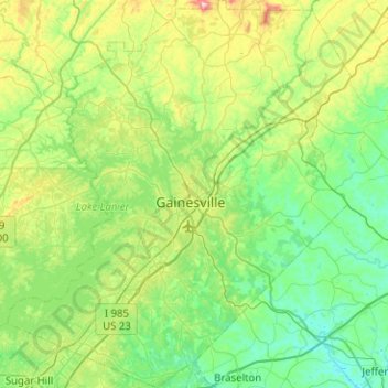
Name: Hall County topographic map, elevation, terrain.
Location: Hall County, Georgia, United States (34.09828 -84.06284 34.51410 -83.61529)
Average elevation: 1,112 ft
Minimum elevation: 682 ft
Maximum elevation: 2,536 ft
Georgia trails, hiking, mountain biking, running and outdoor activities
Other topographic maps
Click on a map to view its topography, its elevation and its terrain.
Atlanta
United States > Georgia > Fulton County
Atlanta occupies a high, rolling part of the Georgia Piedmont, a physiographic region described as a landscape of low hills and narrow valleys between the Blue Ridge Mountains and the Upper Coastal Plain. Around downtown and Fulton County, the terrain is gently dissected rather than flat, with broad urban…
Average elevation: 935 ft
Vinings
United States > Georgia > Cobb County
Vinings features a varied topography characterized by rolling hills and lush, wooded areas that provide a picturesque backdrop to the community. The area is nestled alongside the Chattahoochee River, which contributes to the gentle slopes and valleys that define the landscape. Elevations in Vinings typically…
Average elevation: 922 ft
Stone Mountain
United States > Georgia > DeKalb County
The park is owned by the state of Georgia and is currently managed by Herschend Family Entertainment. At its summit, the elevation is 1,686 feet (514 m) above sea level and 825 feet (251 m) above the surrounding area. Stone Mountain is well known for not only its geology, but also the enormous rock relief on…
Average elevation: 981 ft
Sawnee Mountain
United States > Georgia > Forsyth County
Sawnee Mountain is a low mountain between the piedmont and Appalachian foothills of the U.S. state of Georgia, north of Atlanta. Average rainfall/46.26in/yr/ average snowfall/5.7in/yr/. The name Sawnee Mountain actually refers to the entire ridge of approximately five miles (8 km) in length. At its summit, the…
Average elevation: 1,325 ft
Alto
United States > Georgia > Banks County > Alto
Alto was so named on account of its (relatively) lofty elevation (1,394 feet above mean sea level). A post office called Alto has been in operation since 1879. The town incorporated in 1895.
Average elevation: 1,325 ft