Hill County topographic map
Interactive map
Click on the map to display elevation.
About this map
![Hill County topographic map, elevation, terrain](/pub/maps/relation/zx5k/8jkmz4/thumbnail.jpg)
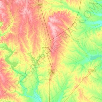
Name: Hill County topographic map, elevation, terrain.
Location: Hill County, Texas, United States (31.70893 -97.49443 32.26699 -96.71913)
Average elevation: 600 ft
Minimum elevation: 394 ft
Maximum elevation: 892 ft
Other topographic maps
Click on a map to view its topography, its elevation and its terrain.
![Houston topographic map, elevation, terrain](/pub/maps/relation/3km2/ln7ks8/icon.jpg)
Houston
United States > Texas > Harris County
Houston, Harris County, Texas, United States
Average elevation: 82 ft
![Austin topographic map, elevation, terrain](/pub/maps/relation/ncm2/4gjdn/icon.jpg)
Austin
United States > Texas > Travis County
Austin, Travis County, Texas, United States
Average elevation: 709 ft
![San Antonio topographic map, elevation, terrain](/pub/maps/relation/xgt6/ph8tj/icon.jpg)
San Antonio
United States > Texas > Bexar County
San Antonio, Bexar County, Texas, United States
Average elevation: 810 ft
![Dallas topographic map, elevation, terrain](/pub/maps/relation/f3kl/6dx4nh/icon.jpg)
Dallas
United States > Texas > Dallas County
Dallas, Dallas County, Texas, United States
Average elevation: 525 ft
![El Paso topographic map, elevation, terrain](/pub/maps/relation/m5mt/wh257/icon.jpg)
El Paso
United States > Texas > El Paso County
El Paso, El Paso County, Texas, United States
Average elevation: 4,058 ft
![Amarillo topographic map, elevation, terrain](/pub/maps/relation/hmm2/4jpdn/icon.jpg)
Amarillo
United States > Texas > Potter County
Amarillo, Potter County, Texas, United States
Average elevation: 3,599 ft
![Beaumont topographic map, elevation, terrain](/pub/maps/relation/fb9m/4jz53q/icon.jpg)
Beaumont
United States > Texas > Jefferson County
Beaumont, Jefferson County, Texas, United States
Average elevation: 20 ft
![Rockport topographic map, elevation, terrain](/pub/maps/relation/9mf3/778pz4/icon.jpg)
Rockport
United States > Texas > Aransas County
Rockport, Aransas County, Texas, 78382, United States
Average elevation: 10 ft
![Conroe topographic map, elevation, terrain](/pub/maps/relation/743l/177cz/icon.jpg)
Conroe
United States > Texas > Montgomery County
Conroe, Montgomery County, Texas, United States
Average elevation: 203 ft
![Waco topographic map, elevation, terrain](/pub/maps/relation/54nx/8j7gp/icon.jpg)
Waco
United States > Texas > McLennan County
Waco, McLennan County, Texas, United States
Average elevation: 482 ft
![Lubbock topographic map, elevation, terrain](/pub/maps/relation/br57/l2d9m/icon.jpg)
Lubbock
United States > Texas > Lubbock County
Lubbock, Lubbock County, Texas, United States
Average elevation: 3,241 ft
![Laredo topographic map, elevation, terrain](/pub/maps/relation/6mkl/t9xm2/icon.jpg)
Laredo
United States > Texas > Webb County
Laredo, Webb County, Texas, United States
Average elevation: 525 ft
![League City topographic map, elevation, terrain](/pub/maps/relation/dgs8/7n9kl/icon.jpg)
League City
United States > Texas > Galveston County
League City, Galveston County, Texas, 77573, United States
Average elevation: 23 ft
![New Braunfels topographic map, elevation, terrain](/pub/maps/relation/mlmt/wh957/icon.jpg)
New Braunfels
United States > Texas > Comal County
New Braunfels, Comal County, Texas, United States
Average elevation: 748 ft
![Frisco topographic map, elevation, terrain](/pub/maps/relation/kznh/j5m3t6/icon.jpg)
Frisco
United States > Texas > Collin County
Frisco, Collin County, Texas, United States
Average elevation: 659 ft
![Kingwood topographic map, elevation, terrain](/pub/maps/node/pj3q/lk2vr31h/icon.jpg)
Kingwood
United States > Texas > Harris County > Houston
Kingwood, Houston, Harris County, Texas, 77345, United States
Average elevation: 72 ft
![San Marcos topographic map, elevation, terrain](/pub/maps/relation/3p14/3jcnh/icon.jpg)
San Marcos
United States > Texas > Hays County
San Marcos, Hays County, Texas, 78666, United States
Average elevation: 682 ft
![Fort Worth topographic map, elevation, terrain](/pub/maps/relation/k94s/8zhtp/icon.jpg)
Fort Worth
United States > Texas > Tarrant County
Fort Worth, Tarrant County, Texas, United States
Average elevation: 696 ft
![San Angelo topographic map, elevation, terrain](/pub/maps/relation/xsf3/773mz4/icon.jpg)
San Angelo
United States > Texas > Tom Green County
San Angelo, Tom Green County, Texas, United States
Average elevation: 1,890 ft
![Abilene topographic map, elevation, terrain](/pub/maps/relation/25nx/5kwgnx/icon.jpg)
Abilene
United States > Texas > Taylor County
Abilene, Taylor County, Texas, United States
Average elevation: 1,749 ft
![Cypress topographic map, elevation, terrain](/pub/maps/node/7rnh/h3tg7rr/icon.jpg)
Cypress
United States > Texas > Harris County
Cypress, Harris County, Texas, 77433, United States
Average elevation: 151 ft
![Port Aransas topographic map, elevation, terrain](/pub/maps/relation/l1gt/ffhvmt/icon.jpg)
Port Aransas
United States > Texas > Nueces County
Port Aransas, Nueces County, Texas, 78373, United States
Average elevation: 3 ft
![Longview topographic map, elevation, terrain](/pub/maps/relation/m1tp/fc2s8/icon.jpg)
Longview
United States > Texas > Gregg County
Longview, Gregg County, Texas, United States
Average elevation: 344 ft
![Dripping Springs topographic map, elevation, terrain](/pub/maps/relation/m551/ttq9tj/icon.jpg)
Dripping Springs
United States > Texas > Hays County
Dripping Springs, Hays County, Texas, United States
Average elevation: 1,168 ft
![Baytown topographic map, elevation, terrain](/pub/maps/relation/m3mt/wh757/icon.jpg)
Baytown
United States > Texas > Harris County
Baytown, Harris County, Texas, United States
Average elevation: 23 ft
![Fredericksburg topographic map, elevation, terrain](/pub/maps/relation/1ntj/9vt13l/icon.jpg)
Fredericksburg
United States > Texas > Gillespie County
Fredericksburg, Gillespie County, Texas, United States
Average elevation: 1,726 ft
![Lago Vista topographic map, elevation, terrain](/pub/maps/relation/t9cz/ffpqgt/icon.jpg)
Lago Vista
United States > Texas > Travis County
Lago Vista, Travis County, Texas, United States
Average elevation: 823 ft
![Galveston topographic map, elevation, terrain](/pub/maps/relation/b25k/r61tj/icon.jpg)
Galveston
United States > Texas > Galveston County
Galveston, Galveston County, Texas, United States
Average elevation: 3 ft
![Pearland topographic map, elevation, terrain](/pub/maps/relation/hl51/6v74s/icon.jpg)
Pearland
United States > Texas > Brazoria County
Pearland, Brazoria County, Texas, 77581, United States
Average elevation: 46 ft
![Denton topographic map, elevation, terrain](/pub/maps/relation/6ks8/7tdkl/icon.jpg)
Denton
United States > Texas > Denton County
Denton, Denton County, Texas, United States
Average elevation: 640 ft
![Dallas topographic map, elevation, terrain](/pub/maps/node/flnh/24lb8rr/icon.jpg)
Dallas
United States > Texas > Dallas County
Dallas, Dallas County, Texas, United States
Average elevation: 518 ft
![Williamson County topographic map, elevation, terrain](/pub/maps/relation/m8m2/sz9k18/icon.jpg)
Williamson County
Williamson County, Texas, United States
Average elevation: 728 ft
![Van Zandt County topographic map, elevation, terrain](/pub/maps/relation/jftf/hg7tmt/icon.jpg)
Van Zandt County
Van Zandt County, Texas, United States
Average elevation: 463 ft
![Montgomery County topographic map, elevation, terrain](/pub/maps/relation/kgt/69ljtf/icon.jpg)
Montgomery County
Montgomery County, Texas, United States
Average elevation: 226 ft
![Round Rock topographic map, elevation, terrain](/pub/maps/relation/8ldn/2kr3q/icon.jpg)
Round Rock
United States > Texas > Williamson County
Round Rock, Williamson County, Texas, United States
Average elevation: 794 ft
![Arlington topographic map, elevation, terrain](/pub/maps/relation/4351/6nd4s/icon.jpg)
Arlington
United States > Texas > Tarrant County
Arlington, Tarrant County, Texas, United States
Average elevation: 571 ft
![Kerrville topographic map, elevation, terrain](/pub/maps/relation/klz4/xhbt18/icon.jpg)
Kerrville
United States > Texas > Kerr County
Kerrville, Kerr County, Texas, United States
Average elevation: 1,788 ft
![McAllen topographic map, elevation, terrain](/pub/maps/relation/8xgp/sz6z4/icon.jpg)
McAllen
United States > Texas > Hidalgo County
McAllen, Hidalgo County, Texas, United States
Average elevation: 131 ft
![Henderson County topographic map, elevation, terrain](/pub/maps/relation/7cnh/3qx29m/icon.jpg)
Henderson County
Henderson County, Texas, United States
Average elevation: 417 ft
![Canyon Lake topographic map, elevation, terrain](/pub/maps/node/6mgp/vh1s6tj/icon.jpg)
Canyon Lake
United States > Texas > Comal County
Canyon Lake, Comal County, Texas, 78133, United States
Average elevation: 971 ft
![Lindale topographic map, elevation, terrain](/pub/maps/relation/7f3l/16bcz/icon.jpg)
Lindale
United States > Texas > Smith County
Lindale, Smith County, Texas, 75771, United States
Average elevation: 515 ft
![Galveston Island topographic map, elevation, terrain](/pub/maps/node/mjdn/rbg4w4s/icon.jpg)
Galveston Island
United States > Texas > Galveston County > Galveston
Galveston Island, Galveston, Galveston County, Texas, 77554, United States
Average elevation: 7 ft