
McDowell County topographic map
Interactive map
Click on the map to display elevation.
McDowell County
Archaeological excavations performed by Dr. David Moore during the early 1980s, revealed artifacts and other evidence that the earliest inhabitants of McDowell County lived there from the Woodland period and Mississippian culture era, from 250 to 1500 AD. Dr. Moore discovered this material in an area close to the Catawba River, in and around an unusual topographical site known as Round Hill. Both the historic Cherokee and Catawba Indians were Native American peoples known to live in what is now McDowell County, and they had been there long before any Europeans. These Native Americans were living in this section for centuries before the Spanish Juan Pardo's 1566 expedition to the interior region from the Atlantic coast.
About this map
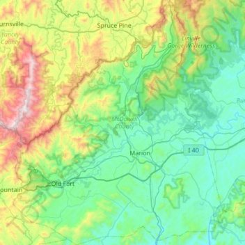
Name: McDowell County topographic map, elevation, terrain.
Location: McDowell County, North Carolina, United States (35.51799 -82.29503 35.96006 -81.82413)
Average elevation: 2,238 ft
Minimum elevation: 955 ft
Maximum elevation: 6,555 ft
North Carolina trails, hiking, mountain biking, running and outdoor activities
Other topographic maps
Click on a map to view its topography, its elevation and its terrain.
Appalachian Mountains
United States > North Carolina > Yancey County
The Appalachian Mountains (French: Appalaches), often called the Appalachians, are a system of mountains in eastern to northeastern North America. The Appalachians first formed roughly 480 million years ago during the Ordovician Period. They once reached elevations similar to those of the Alps and the Rocky…
Average elevation: 4,800 ft
Highlands
United States > North Carolina > Macon County > Highlands
Highlands was founded in 1875 after its two founders, Samuel Truman Kelsey and Clinton Carter Hutchinson, drew lines from Chicago to Savannah and from New Orleans to New York City. They felt that the place where these lines met would eventually become a great trading center and commercial crossroads. Highlands…
Average elevation: 3,576 ft
Country Club Estates
United States > North Carolina > Alamance County > Burlington
Average elevation: 640 ft
Loch Lommond
United States > North Carolina > Cumberland County > Fayetteville
Average elevation: 230 ft
Shadowlawn
United States > North Carolina > Cumberland County > Fayetteville
Average elevation: 187 ft
Ballantyne's Backyard
United States > North Carolina > Mecklenburg County > Charlotte
Average elevation: 600 ft
Hoopers Creek
United States > North Carolina > Henderson County > Fletcher
Average elevation: 2,221 ft
Maplewood
United States > North Carolina > Richmond County > Rockingham > East Rockingham
Average elevation: 272 ft
Shadowlawn
United States > North Carolina > Cumberland County > Fayetteville
Average elevation: 187 ft
Mount Mitchell
United States > North Carolina > Yancey County
Mount Mitchell (Attakulla in Cherokee) is the highest peak of the Appalachian Mountains and the highest peak in mainland North America east of the Mississippi River. It is located near Burnsville in Yancey County, North Carolina in the Black Mountain subrange of the Appalachians about 19 miles (31 km)…
Average elevation: 5,719 ft
Mount Mitchell
United States > North Carolina > Yancey County
Mount Mitchell, known in Cherokee as Attakulla, is the highest peak of the Appalachian Mountains and the highest peak in mainland eastern North America. It is located near Burnsville in Yancey County, North Carolina in the Black Mountain subrange of the Appalachians about 19 miles (31 km) northeast of…
Average elevation: 5,719 ft
Appalachian Ski Mountain Dam
United States > North Carolina > Watauga County
Average elevation: 3,652 ft
Reynolda Village
United States > North Carolina > Forsyth County > Winston-Salem
Average elevation: 912 ft
Tuckaseegee Park
United States > North Carolina > Mecklenburg County > Charlotte
Average elevation: 764 ft
Atwood Acres
United States > North Carolina > Forsyth County > Winston-Salem
Average elevation: 791 ft
Oak Ridge Park
United States > North Carolina > Richmond County > East Rockingham
Average elevation: 279 ft
Hideaway Mountain Lake Dam
United States > North Carolina > Cherokee County
Average elevation: 2,159 ft
Sharon Colony
United States > North Carolina > Mecklenburg County > Charlotte
Average elevation: 659 ft
Wilmington Beach
United States > North Carolina > New Hanover County > Carolina Beach
Average elevation: 7 ft
Appalachian Mountains
United States > North Carolina > Yancey County
The range is older than the other major mountain range in North America, the Rocky Mountains of the west. Some of the outcrops in the Appalachians contain rocks formed during the Precambrian era. The geologic processes that led to the formation of the Appalachian Mountains started 1.1 billion years ago. The…
Average elevation: 4,800 ft
Bald Head Island
United States > North Carolina > Brunswick County > Bald Head Island
Average elevation: 10 ft
Cul Res Town Creek Indian Mound
United States > North Carolina > Montgomery County
Average elevation: 233 ft
Wilmington Beach
United States > North Carolina > New Hanover County > Carolina Beach
Average elevation: 7 ft