
Nuapada topographic map
Interactive map
Click on the map to display elevation.
Nuapada
The plains of Nuapada subdivision are fringed by rugged hill ranges stretching southward, which belong to the main line of the Eastern Ghats and contain extensive plateaus of about 4000 ft (1200 m) in elevation.
About this map
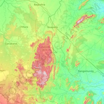
Name: Nuapada topographic map, elevation, terrain.
Location: Nuapada, Odisha, India (19.99084 82.33128 21.09231 82.86133)
Average elevation: 1,198 ft
Minimum elevation: 581 ft
Maximum elevation: 3,291 ft
Other topographic maps
Click on a map to view its topography, its elevation and its terrain.
Cuttack
India > Odisha > Cuttack (M.Corp.) P.S
Cuttack is located at 20°31′23″N 085°47′17″E / 20.52306°N 85.78806°E / 20.52306; 85.78806 and has an average elevation of 36 metres (118 ft). The city is spread across an area of 192.5 km2 (74 sq mi). The city, being a Cuttack Municipal Corporation which consists of 59 wards. The city…
Average elevation: 112 ft
JOBRA CANAL(TALADANDA CANAL)
India > Odisha > Cuttack (M.Corp.) P.S > Cuttack
Average elevation: 89 ft
Bhubaneshwar
India > Odisha > Bhubaneswar (M.Corp.)
Bhubaneswar is in Khordha district of Odisha. It is in the eastern coastal plains, along the axis of the Eastern Ghats mountains. The city has an average altitude of 45 m (148 ft) above sea level. It lies southwest of the Mahanadi River that forms the northern boundary of Bhubaneswar metropolitan area, within…
Average elevation: 98 ft
Mahendragiri
India > Odisha > Ramagiri > Burakhat
Mahendragiri, is a mountain in Rayagada block of the district of Gajapati, Odisha, India. It is situated amongst the Eastern Ghats at an elevation of 1,501 metres (4,925 ft). The second highest mountain of Odisha.
Average elevation: 3,635 ft
Baripada
India > Odisha > Baripada (M)
Baripada is at 21°56′N 86°43′E / 21.94°N 86.72°E / 21.94; 86.72. It has an average elevation of 36 metres (118 feet). The city lies along the Budhabalanga River.
Average elevation: 135 ft
Koraput
India > Odisha > Koraput Town
Koraput is located at 18°49′N 82°43′E / 18.82°N 82.72°E / 18.82; 82.72. It has an average elevation of 870 m (2,850 ft).
Average elevation: 2,825 ft
Sambalpur
Sambalpur is located at 21°.27' North Latitude and 83°.58' East Longitude. The average elevation is 150.75 metres (494.6 ft) above the mean sea level. Sambalpur falls under the Zone-3 seismic number, which shows the possibility of an earthquake.
Average elevation: 597 ft
Eastern Ghats
India > Odisha > Ramagiri > Burakhat
The Eastern Ghats is a mountain range that stretches 1,750 km (1,090 mi) along the eastern coast of the Indian peninsula. Covering an area of 75,000 km2 (29,000 sq mi), it traverses the states of Odisha, Telangana, Andhra Pradesh, Karnataka, and Tamil Nadu. The range forms a discontinuous chain of mountains…
Average elevation: 3,707 ft
Rourkela
India > Odisha > Raurkela (M)
Rourkela is located at 84.54E longitude and 22.12N latitude in Sundergarh district of Odisha at an elevation of about 219 m (719 ft) above mean sea level. The area of Rourkela is 200 square kilometers approximately. Being situated on the Howrah-Mumbai rail track, Rourkela had an added advantage of the steel…
Average elevation: 778 ft
Phulbani
India > Odisha > Phulabani Town
Phulbani is located at 20°28′N 84°14′E / 20.47°N 84.23°E / 20.47; 84.23. It has an average elevation of 485 metres (1591 feet).
Average elevation: 1,703 ft
Bhubaneshwar
India > Odisha > Bhubaneswar (M.Corp.)
Bhubaneswar is in Khordha district of Odisha. It is in the eastern coastal plains, along the axis of the Eastern Ghats mountains. The city has an average altitude of 45 m (148 ft) above sea level. It lies southwest of the Mahanadi River that forms the northern boundary of Bhubaneswar metropolitan area, within…
Average elevation: 98 ft
Netaji Subash chandra Bose Park
India > Odisha > Bhubaneswar (M.Corp.) > Bhubaneswar Municipal Corporation
Average elevation: 112 ft
Angul
Angul (also known as Anugul) is a town and a municipality and the headquarters of Angul district in the state of Odisha, India. Angul has an average elevation of 195 m (640 ft) above sea level. The total geographical area of the district is 6232 km2. From the point of view of area, it stands 11th among the 30…
Average elevation: 397 ft