
Illinois topographic map
Interactive map
Click on the map to display elevation.
Illinois
Illinois features a diverse topography characterized primarily by broad, fertile plains and some hilly regions. The state is predominantly flat, with about 90% covered by the Central Plains, particularly the Till Plains, which are rich agricultural lands shaped by glacial activity during the last Ice Age. The highest elevation is found at Charles Mound, reaching 1,235 feet above sea level, while the lowest point is at the confluence of the Ohio and Mississippi Rivers in the Gulf Coastal Plain, which sits at approximately 279 feet. Southern Illinois is notably distinct with the Shawnee Hills, which present rolling hills and wooded valleys, contrasting with the flatter terrain found in the north. Additionally, significant rivers such as the Mississippi and Illinois contribute to the landscape's dynamism, forming floodplains and fertile valleys that have influenced settlement patterns and agriculture throughout the region.
About this map
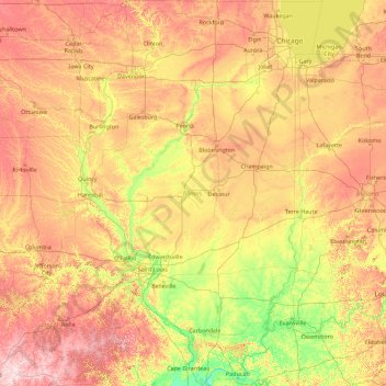
Name: Illinois topographic map, elevation, terrain.
Location: Illinois, United States (36.97013 -91.51305 42.50837 -87.01992)
Average elevation: 699 ft
Minimum elevation: 299 ft
Maximum elevation: 1,732 ft
United States trails, hiking, mountain biking, running and outdoor activities
Other topographic maps
Click on a map to view its topography, its elevation and its terrain.
Appalachian Mountains
United States > North Carolina > Yancey County
The Appalachian Mountains (French: Appalaches), often called the Appalachians, are a system of mountains in eastern to northeastern North America. The Appalachians first formed roughly 480 million years ago during the Ordovician Period. They once reached elevations similar to those of the Alps and the Rocky…
Average elevation: 4,800 ft
Virginia Beach
United States > Virginia > Virginia Beach
According to the United States Census Bureau, the city has a total area of 497 square miles (1,290 km2), of which 249 square miles (640 km2) is land and 248 square miles (640 km2) (49.9%) is water. It is the largest city in Virginia by total area and third-largest city land area. The average elevation is 12…
Average elevation: 7 ft
Baltimore
United States > Maryland > Baltimore
Baltimore is in north-central Maryland on the Patapsco River close to where it empties into the Chesapeake Bay. The city is also located on the fall line between the Piedmont Plateau and the Atlantic coastal plain, which divides Baltimore into "lower city" and "upper city". The city's elevation ranges from sea…
Average elevation: 213 ft
San Francisco Bay Area
United States > California > San Francisco
The San Francisco Bay Area is characterized by a diverse and dynamic topography shaped by geological processes over millions of years. This region features a combination of coastal plains, steep hills, and rugged mountains, all influenced by the tectonic activity associated with the nearby San Andreas Fault…
Average elevation: 371 ft
Mauna Loa
United States > Hawaii > Hawaiʻi County
Mauna Loa is the largest subaerial and second largest overall volcano in the world (behind Tamu Massif), covering a land area of 5,271 km2 (2,035 sq mi) and spans a maximum width of 120 km (75 mi). Consisting of approximately 65,000 to 80,000 km3 (15,600 to 19,200 cu mi) of solid rock, it makes up more than…
Average elevation: 13,245 ft
Port Charlotte
United States > Florida > Charlotte County
Port Charlotte is characterized by a predominantly flat and low-lying terrain, typical of Florida’s coastal landscape. The area features a network of waterways, including the Peace River and Charlotte Harbor, which provide ample opportunities for recreational activities like boating and fishing. Elevations…
Average elevation: 13 ft
Lakewood
United States > Colorado > Jefferson County > Lakewood
Lakewood is located at 39°42′17″N 105°04′53″W / 39.70472°N 105.08139°W / 39.70472; -105.08139 at an elevation of 5,518 feet (1,682 m). Located at the junction of U.S. Route 6 and Colorado State Highway 121 in central Colorado, the city lies immediately west of Denver and 62 miles (100 km)…
Average elevation: 5,633 ft
Heineberg Bridge Fishing Wilderness Access
United States > Vermont > Chittenden County
Average elevation: 128 ft
Monarch Pass
United States > Colorado > Gunnison County
Monarch Pass (elevation 11,312 feet (3,448 m)) is a high mountain pass in central Colorado, in the Rocky Mountains of the western United States.
Average elevation: 11,217 ft
Central Park
United States > New York > New York County > New York
In June 1856, Fernando Wood appointed a "consulting board" of seven people, headed by author Washington Irving, to inspire public confidence in the proposed development. Wood hired military engineer Egbert Ludovicus Viele as the park's chief engineer, tasking him with a topographical survey of the site. The…
Average elevation: 85 ft
Estes Park
United States > Colorado > Larimer County
Estes Park sits at an elevation of 7,522 feet (2,293 m) on the front range of the Rocky Mountains at the eastern entrance of the Rocky Mountain National Park. Its north, south and east extremities border the Roosevelt National Forest. Lumpy Ridge lies immediately north of Estes Park.
Average elevation: 8,343 ft
Quiambaug
United States > Connecticut > Southeastern Connecticut Planning Region > Mystic
Average elevation: 26 ft
Cowdens Corner
United States > New York > Chautauqua County > Town of Arkwright
Average elevation: 1,276 ft
Scottsdale
United States > Arizona > Maricopa County > Scottsdale
The city is in the Salt River Valley, or the "Valley of the Sun," in the northern reaches of the Sonoran Desert. Scottsdale, 31 mi (50 km) long and 11.4 mi (18.3 km) wide at its widest point, shares boundaries with many other municipalities and entities. On the west, Scottsdale is bordered by Phoenix, Paradise…
Average elevation: 1,358 ft
Mount Rushmore
United States > South Dakota > Pennington County
Mount Rushmore National Memorial is centered on a colossal sculpture carved into the granite face of Mount Rushmore (Lakota: Tȟuŋkášila Šákpe, or Six Grandfathers) in the Black Hills near Keystone, South Dakota. Sculptor Gutzon Borglum created the sculpture's design and oversaw the project's execution…
Average elevation: 5,125 ft
Mount Adams
United States > Washington > Yakima County
Adams is one of the long-lived volcanoes in the Cascade Range, with minor activity beginning 900,000 years ago and major cone building activity beginning 520,000 years ago. The whole mountain has been completely eroded by glaciers to an elevation of 8,200 feet (2,500 m) twice during its lifetime. The current…
Average elevation: 10,614 ft
Central Park
United States > New York > New York County > New York
In June 1856, Fernando Wood appointed a "consulting board" of seven people, headed by author Washington Irving, to inspire public confidence in the proposed development. Wood hired military engineer Egbert Ludovicus Viele as the park's chief engineer, tasking him with a topographical survey of the site. The…
Average elevation: 85 ft
Parrish
United States > Florida > Manatee County
Parrish features a predominantly flat terrain with an average elevation of approximately 36 feet above sea level. The area's landscape is characterized by gently rolling hills and low-lying regions, making it typical of the Central Florida topography. Surrounding Parrish are numerous wetlands and drainage…
Average elevation: 39 ft
Evergreen
United States > Colorado > Jefferson County
Evergreen sits at an elevation of 7,220 feet (2,200 m) in the Rocky Mountains, 19 miles west of Denver, Colorado. Its addresses are oriented according to the Street_system_of_Denver.
Average elevation: 7,575 ft
Edwin Warner Park
United States > Tennessee > Davidson County > Nashville > Devonshire Manor
Average elevation: 650 ft
South End
United States > Connecticut > Western Connecticut Planning Region > Stamford
Average elevation: 36 ft
Cathedral Rock
United States > Arizona > Yavapai County
Cathedral Rock is a natural sandstone butte near Sedona, Arizona, and one of the most-photographed sights in Arizona, United States. The rock formation is located in the Coconino National Forest in Yavapai County, about 1 mi (1.6 km) west of Arizona Route 179, and about 2.5 mi (4.0 km) south of the "Y"…
Average elevation: 4,206 ft
East Texas
United States > Pennsylvania > Lehigh County > Lower Macungie Township
Average elevation: 413 ft
Florida Keys
United States > Florida > Monroe County
Tropical cyclones present special dangers and challenges to the entire Keys. Because no area of the islands is more than 20 feet (6.1 m) above sea level (and many are only a few feet elevation), and water surrounds the islands, nearly every neighborhood is subject to flooding as well as hurricane winds. In…
Average elevation: 0 ft