
Lynchburg topographic map
Interactive map
Click on the map to display elevation.
Lynchburg
Lynchburg has a four-season humid subtropical climate (Köppen Cfa), with cool winters and hot, humid summers. The monthly daily average temperature ranges from 35.9 °F (2.2 °C) in January to 76.0 °F (24.4 °C) in July. Nights tend to be significantly cooler than days throughout much of the year due in part to the moderate elevation. In a typical year, there are 27.4 days with a high temperature 90 °F (32 °C) or above, and 6.2 days with a high of 32 °F (0 °C) or below. Snowfall averages 11.6 inches (29 cm) per season but this amount varies highly with each winter; the snowiest winter is 1995–96 with 56.8 in (144 cm) of snow, but the following winter recorded only trace amounts, the least on record.
About this map
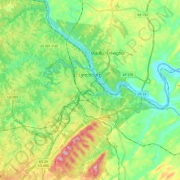
Name: Lynchburg topographic map, elevation, terrain.
Location: Lynchburg, Virginia, United States (37.33264 -79.27139 37.46940 -79.08449)
Average elevation: 751 ft
Minimum elevation: 466 ft
Maximum elevation: 1,325 ft
Virginia trails, hiking, mountain biking, running and outdoor activities
Other topographic maps
Click on a map to view its topography, its elevation and its terrain.
Virginia Beach
United States > Virginia > Virginia Beach
According to the United States Census Bureau, the city has a total area of 497 square miles (1,290 km2), of which 249 square miles (640 km2) is land and 248 square miles (640 km2) (49.9%) is water. It is the largest city in Virginia by total area and third-largest city land area. The average elevation is 12…
Average elevation: 7 ft
Blue Ridge Mountains
United States > Virginia > Botetourt County
Although the term "Blue Ridge" is sometimes applied exclusively to the eastern edge or front range of the Appalachian Mountains, the geological definition of the Blue Ridge province extends westward to the Ridge and Valley area, encompassing the Great Smoky Mountains, the Great Balsams, the Roans, the Blacks,…
Average elevation: 1,509 ft
Eggleston
United States > Virginia > Giles County
It lies at an elevation of 1,821 feet.
Average elevation: 1,877 ft
Prince William Forest Park
United States > Virginia > Prince William County > Triangle
Average elevation: 266 ft