
Roanoke topographic map
Interactive map
Click on the map to display elevation.
Roanoke
Roanoke is characterized by a diverse topography, nestled within the Appalachian Mountains and the scenic Blue Ridge region. The city is situated at an elevation of approximately 1,100 feet, with the surrounding terrain consisting of rolling hills and valleys, predominantly shaped by the nearby Roanoke River. This river flows through the city and is flanked by steep slopes and ridges, creating a picturesque landscape. The area is also home to various natural features, including the Peaks of Otter and the expansive George Washington National Forest, which enhance the region’s topographical diversity. The interplay of mountains, rivers, and valleys contributes to a vibrant ecosystem, making Roanoke a gateway to numerous outdoor recreational opportunities.
About this map
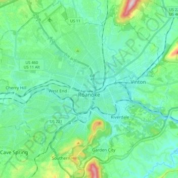
Name: Roanoke topographic map, elevation, terrain.
Location: Roanoke, Virginia, United States (37.21190 -80.03748 37.33761 -79.87855)
Average elevation: 1,093 ft
Minimum elevation: 823 ft
Maximum elevation: 2,231 ft
Virginia trails, hiking, mountain biking, running and outdoor activities
Other topographic maps
Click on a map to view its topography, its elevation and its terrain.
Virginia Beach
United States > Virginia > Virginia Beach
According to the United States Census Bureau, the city has a total area of 497 square miles (1,290 km2), of which 249 square miles (640 km2) is land and 248 square miles (640 km2) (49.9%) is water. It is the largest city in Virginia by total area and third-largest city land area. The average elevation is 12…
Average elevation: 7 ft
Blue Ridge Mountains
United States > Virginia > Botetourt County
Although the term "Blue Ridge" is sometimes applied exclusively to the eastern edge or front range of the Appalachian Mountains, the geological definition of the Blue Ridge province extends westward to the Ridge and Valley area, encompassing the Great Smoky Mountains, the Great Balsams, the Roans, the Blacks,…
Average elevation: 1,509 ft
Eggleston
United States > Virginia > Giles County
It lies at an elevation of 1,821 feet.
Average elevation: 1,877 ft
Prince William Forest Park
United States > Virginia > Prince William County > Triangle
Average elevation: 266 ft