Make a donation
Gear up for your next adventure:
As an Amazon Associate, this site earns from qualifying purchases at no extra cost to you.
Williamson County topographic map
Click on the map to display elevation.
Make a donation
Gear up for your next adventure:
As an Amazon Associate, this site earns from qualifying purchases at no extra cost to you.
Williamson County
The area is divided into two regions by the Balcones Escarpment, which runs through the center from north to south along a line from Jarrell to Georgetown to Round Rock. The county's western half is an extension of the Western Plains and considered to be within the eastern fringes of Texas Hill Country; it has an average elevation of 850 ft (260 m). It features undulating, hilly brushland with an abundance of Texas live oak, prickly pear cactus, and karst. The county's eastern half is part of the Coastal Plains and is flat to gently rolling with an average elevation of 600 ft (180 m). It has dark clay and rich, fertile soils for agriculture, but is quickly being developed as the county's population continues to increase and expand out. Williamson County is drained in the center and south by the San Gabriel River, the county's only river, and in the north by creeks that run into the Lampasas and Little Rivers north of the county line.
Make a donation
Gear up for your next adventure:
As an Amazon Associate, this site earns from qualifying purchases at no extra cost to you.
About this map
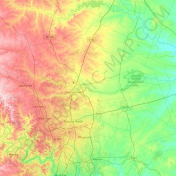
Name: Williamson County topographic map, elevation, terrain.
Location: Williamson County, Texas, United States (30.40281 -98.05005 30.90559 -97.15520)
Average elevation: 728 ft
Minimum elevation: 361 ft
Maximum elevation: 1,368 ft
Texas trails, hiking, mountain biking, running and outdoor activities
Make a donation
Gear up for your next adventure:
As an Amazon Associate, this site earns from qualifying purchases at no extra cost to you.
Other topographic maps
Click on a map to view its topography, its elevation and its terrain.
Make a donation
Gear up for your next adventure:
As an Amazon Associate, this site earns from qualifying purchases at no extra cost to you.
Make a donation
Gear up for your next adventure:
As an Amazon Associate, this site earns from qualifying purchases at no extra cost to you.
Make a donation
Gear up for your next adventure:
As an Amazon Associate, this site earns from qualifying purchases at no extra cost to you.
Georgetown
United States > Texas > Georgetown
The city is located on the northeastern edge of Texas Hill Country. Portions of Georgetown are located on either side of the Balcones Escarpment, a fault line in which the areas roughly east of IH-35 are flat and characterized by having black, fertile soils of the Blackland Prairie, and the west side of the…
Average elevation: 719 ft
Make a donation
Gear up for your next adventure:
As an Amazon Associate, this site earns from qualifying purchases at no extra cost to you.
Make a donation
Gear up for your next adventure:
As an Amazon Associate, this site earns from qualifying purchases at no extra cost to you.
Enchanted Rock
United States > Texas > Llano County
Enchanted Rock is a pink granite mountain located in the Llano Uplift about 17 miles (27 km) north of Fredericksburg, Texas and 24 miles (39 km) south of Llano, Texas, United States. Enchanted Rock State Natural Area, which includes Enchanted Rock and surrounding land, spans the border between Gillespie and…
Average elevation: 1,486 ft
Make a donation
Gear up for your next adventure:
As an Amazon Associate, this site earns from qualifying purchases at no extra cost to you.
Make a donation
Gear up for your next adventure:
As an Amazon Associate, this site earns from qualifying purchases at no extra cost to you.
Make a donation
Gear up for your next adventure:
As an Amazon Associate, this site earns from qualifying purchases at no extra cost to you.
Guadalupe Peak
United States > Texas > Culberson County
Guadalupe Peak, also known as Signal Peak, is the highest natural point in Texas, with an elevation of 8,751 feet (2,667 m) above sea level. It is located in Guadalupe Mountains National Park, and is part of the Guadalupe Mountains range in southeastern New Mexico and West Texas. The mountain is about 90 miles…
Average elevation: 7,054 ft
Sierra Blanca
United States > Texas > Hudspeth County
Sierra Blanca is found in Far West Texas, a subdivision of West Texas, and is 4,520 feet (1,380 m) above sea level. The town is part of the Trans-Pecos region within the most mountainous and arid portion of Texas. The town is located in Hudspeth County, which is large and sparsely populated. Sierra Blanca…
Average elevation: 4,564 ft
Make a donation
Gear up for your next adventure:
As an Amazon Associate, this site earns from qualifying purchases at no extra cost to you.
Pedernales Falls State Park
United States > Texas > Blanco County > Johnson City
Average elevation: 994 ft
Make a donation
Gear up for your next adventure:
As an Amazon Associate, this site earns from qualifying purchases at no extra cost to you.
Will Rogers Memorial Center
United States > Texas > Tarrant County > Fort Worth
Average elevation: 594 ft
Make a donation
Gear up for your next adventure:
As an Amazon Associate, this site earns from qualifying purchases at no extra cost to you.
Make a donation
Gear up for your next adventure:
As an Amazon Associate, this site earns from qualifying purchases at no extra cost to you.
Roy G. Guerrero Colorado River Metro Park
United States > Texas > Travis County > Austin
Average elevation: 463 ft
Make a donation
Gear up for your next adventure:
As an Amazon Associate, this site earns from qualifying purchases at no extra cost to you.
Soil Conservation Service Site 12 Dam
United States > Texas > Williamson County > Type
Average elevation: 568 ft
Make a donation
Gear up for your next adventure:
As an Amazon Associate, this site earns from qualifying purchases at no extra cost to you.
Make a donation
Gear up for your next adventure:
As an Amazon Associate, this site earns from qualifying purchases at no extra cost to you.
Make a donation
Gear up for your next adventure:
As an Amazon Associate, this site earns from qualifying purchases at no extra cost to you.
Make a donation
Gear up for your next adventure:
As an Amazon Associate, this site earns from qualifying purchases at no extra cost to you.
Challenger 7 Memorial Park
United States > Texas > Harris County > League City
Average elevation: 20 ft
Make a donation
Gear up for your next adventure:
As an Amazon Associate, this site earns from qualifying purchases at no extra cost to you.
Make a donation
Gear up for your next adventure:
As an Amazon Associate, this site earns from qualifying purchases at no extra cost to you.
Make a donation
Gear up for your next adventure:
As an Amazon Associate, this site earns from qualifying purchases at no extra cost to you.
Make a donation
Gear up for your next adventure:
As an Amazon Associate, this site earns from qualifying purchases at no extra cost to you.
Make a donation
Gear up for your next adventure:
As an Amazon Associate, this site earns from qualifying purchases at no extra cost to you.
Make a donation
Gear up for your next adventure:
As an Amazon Associate, this site earns from qualifying purchases at no extra cost to you.
Make a donation
Gear up for your next adventure:
As an Amazon Associate, this site earns from qualifying purchases at no extra cost to you.
Make a donation
Gear up for your next adventure:
As an Amazon Associate, this site earns from qualifying purchases at no extra cost to you.
