Geolocate

Isanti County topographic map

Interactive map

Click on the map to display elevation.

About this map

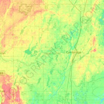
Name: Isanti County topographic map, elevation, terrain.

Location: Isanti County, Minnesota, United States (45.41176 -93.51368 45.73432 -93.01950)

Average elevation: 958 ft

Minimum elevation: 883 ft

Maximum elevation: 1,093 ft

Minnesota trails, hiking, mountain biking, running and outdoor activities

Other topographic maps

Click on a map to view its topography, its elevation and its terrain.

Minneapolis

United States > Minnesota > Hennepin County > Minneapolis

A 1959 report by the U.S. Soil Conservation Service listed Minneapolis's elevation as 830 feet (250 m). The city's lowest elevation of 687 feet (209 m) above sea level is near where Minnehaha Creek meets the Mississippi River. Sources disagree on the exact location and elevation of the city's highest point,…

Average elevation: 889 ft

Sunrise Court

United States > Minnesota > McLeod County > Glencoe

Average elevation: 1,014 ft

Shohola Lake

United States > Minnesota > Saint Louis County

Average elevation: 1,358 ft

Lime Creek

United States > Minnesota > Murray County

Average elevation: 1,535 ft

Chase Lake

United States > Minnesota > Cook County

Average elevation: 1,791 ft

Rocky Lake

United States > Minnesota > Cook County

Average elevation: 1,719 ft

Little Snow Lake

United States > Minnesota > Cook County

Average elevation: 1,903 ft

Norway Lake

United States > Minnesota > Kandiyohi County

Average elevation: 1,217 ft

Lake Agnes

United States > Minnesota > Douglas County > Alexandria

Average elevation: 1,401 ft

Wolford

United States > Minnesota > Crow Wing County

Average elevation: 1,224 ft

Rodgers Lake

United States > Minnesota > Todd County

Average elevation: 1,293 ft

Pine Center

United States > Minnesota > Crow Wing County

Average elevation: 1,302 ft

Highland

United States > Minnesota > Fillmore County

Average elevation: 1,152 ft

Minnehaha Falls

United States > Minnesota > Hennepin County > Minneapolis

Fortunately for the generations to come, in 1883 the state legislature created the Minneapolis Board of Park Commissioners. The board began by acquiring park land near today's downtown Minneapolis. Their choice to hire noted landscape architect Horace Cleveland was fortunate. Cleveland was hired by the Board…

Average elevation: 817 ft

West Duluth

United States > Minnesota > Saint Louis County > Duluth

Average elevation: 856 ft

Murphy City

United States > Minnesota > Lake County

Average elevation: 1,867 ft

Corset Lake

United States > Minnesota > Cass County

Average elevation: 1,335 ft

Snowshoe Lake

United States > Minnesota > Cass County

Average elevation: 1,332 ft

Burrows Lake

United States > Minnesota > Itasca County

Average elevation: 1,398 ft

Toivola

United States > Minnesota > Saint Louis County

Average elevation: 1,286 ft

Glen Lake

United States > Minnesota > Hennepin County > Minnetonka

Average elevation: 955 ft

Byron

United States > Minnesota > Olmsted County

Average elevation: 1,198 ft

Jolly Ann Lake

United States > Minnesota > Otter Tail County

Average elevation: 1,289 ft

Saint Paul

United States > Minnesota > Ramsey County > Saint Paul

The year 1858 saw more than 1,000 steamboats service Saint Paul, making it a gateway for settlers to the Minnesota frontier or Dakota Territory. Geography was a primary reason the city became a transportation hub. The location was the last good point to land riverboats coming upriver due to the river valley's…

Average elevation: 896 ft

Benning

United States > Minnesota > Blue Earth County > Mankato

Average elevation: 843 ft

City park

United States > Minnesota > Saint Louis County > Duluth

Average elevation: 676 ft

Bucks Mill

United States > Minnesota > Becker County

Average elevation: 1,345 ft

Green Lake

United States > Minnesota > Beltrami County > Little Rock

Average elevation: 1,243 ft

Big Deep Lake

United States > Minnesota > Cass County

Average elevation: 1,378 ft

Stanchfield

United States > Minnesota > Isanti County

Average elevation: 942 ft

Gainy Park

United States > Minnesota > Steele County > Owatonna

Average elevation: 1,178 ft

Shorewood

United States > Minnesota > Hennepin County

Average elevation: 961 ft

Glendale

United States > Minnesota > Scott County > Savage

Average elevation: 860 ft

Day

United States > Minnesota > Isanti County

Average elevation: 991 ft

Grandy

United States > Minnesota > Isanti County

Average elevation: 935 ft

Carmody

United States > Minnesota > Isanti County

Average elevation: 981 ft

Elm Park

United States > Minnesota > Isanti County

Average elevation: 951 ft

Oxlip

United States > Minnesota > Isanti County

Average elevation: 945 ft

Spring Lake

United States > Minnesota > Isanti County

Average elevation: 938 ft

Andree

United States > Minnesota > Isanti County

Average elevation: 955 ft

Money Creek

United States > Minnesota > Houston County

Average elevation: 896 ft

Crown

United States > Minnesota > Isanti County

Average elevation: 968 ft

Dalbo

United States > Minnesota > Isanti County

Average elevation: 971 ft

Spencer Brook

United States > Minnesota > Isanti County

Average elevation: 948 ft

Walbo

United States > Minnesota > Isanti County

Average elevation: 938 ft

Weber

United States > Minnesota > Isanti County

Average elevation: 925 ft

Wyanett

United States > Minnesota > Isanti County

Average elevation: 961 ft

Bodum

United States > Minnesota > Isanti County

Average elevation: 965 ft

Pine Brook

United States > Minnesota > Isanti County

Average elevation: 955 ft

Springvale

United States > Minnesota > Isanti County

Average elevation: 945 ft

Stanley

United States > Minnesota > Isanti County

Average elevation: 961 ft

West Point

United States > Minnesota > Isanti County

Average elevation: 942 ft

Athens

United States > Minnesota > Isanti County

Average elevation: 932 ft

Blomford

United States > Minnesota > Isanti County

Average elevation: 951 ft

Edgewood

United States > Minnesota > Isanti County

Average elevation: 948 ft

Bradford

United States > Minnesota > Isanti County

Average elevation: 942 ft

Willington Grove

United States > Minnesota > Houston County

Average elevation: 1,201 ft

Sheldon

United States > Minnesota > Houston County

Average elevation: 978 ft

Wilmington

United States > Minnesota > Houston County

Average elevation: 1,165 ft

Pine Creek

United States > Minnesota > Houston County

Average elevation: 928 ft

South Ridge

United States > Minnesota > Houston County

Average elevation: 1,037 ft

Newhouse

United States > Minnesota > Houston County

Average elevation: 1,178 ft

Bee

United States > Minnesota > Houston County

Average elevation: 1,063 ft

Yucatan

United States > Minnesota > Houston County

Average elevation: 925 ft

Riceford

United States > Minnesota > Houston County

Average elevation: 1,135 ft

Perkins

United States > Minnesota > Houston County

Average elevation: 896 ft

Pine Creek

United States > Minnesota > Winona County

Average elevation: 1,165 ft

Schechs Mill

United States > Minnesota > Houston County > Sheldon

Average elevation: 1,001 ft

Rum River

United States > Minnesota > Mille Lacs County

Average elevation: 994 ft

Frontenac

United States > Minnesota > Goodhue County

Average elevation: 797 ft

Movil Lake Dam

United States > Minnesota > Beltrami County

Average elevation: 1,365 ft

Oak Knoll

United States > Minnesota > Hennepin County > Minnetonka

Average elevation: 945 ft

Chatfield

United States > Minnesota > Fillmore County

Average elevation: 1,073 ft

Huntley

United States > Minnesota > Faribault County

Average elevation: 1,093 ft

Corning

United States > Minnesota > Mower County

Average elevation: 1,276 ft

Kevin

United States > Minnesota > Itasca County

Average elevation: 1,414 ft

Mahtowa

United States > Minnesota > Carlton County

Average elevation: 1,168 ft

Wasioja

United States > Minnesota > Dodge County

Average elevation: 1,207 ft

Baker

United States > Minnesota > Clay County

Average elevation: 938 ft

Harris Lake

United States > Minnesota > Saint Louis County

Average elevation: 1,588 ft