
Henderson County topographic map
Interactive map
Click on the map to display elevation.
Henderson County
Due to its geographic setting along the Eastern Continental Divide and its extreme topographic variation, Henderson County presents a wide variation in temperature and precipitation conditions. The highest elevations occur along the northwest and northern boundaries of the county and within the Blue Ridge Escarpment, a rugged area of peaks and narrow valleys that rise from the Piedmont to the continental divide and the Blue Ridge Plateau. The lowest elevations occur within the valleys of the escarpment and in the broader valleys of the Blue Ridge Plateau. The mean annual temperature of the county is 55.1 °F, with a range from 50.3 to 57.9 °F depending on the elevation, with higher temperatures occurring at lower elevations and lower temperatures in the higher mountains. The month of July is the hottest in the county, with a mean temperature of 72.6 °F and a mean range of 66.6 to 75.8 °F. The coolest month is January with a mean temperature of 36.9 °F and a mean range of 33.3 to 39.5 °F. Precipitation is also correlated to elevation, with higher precipitation normally occurring at higher elevations and lower precipitation in the valleys. The mean annual precipitation of Henderson County is 56.2 inches, with a mean range of 45.04 to 78.03 inches. March has the highest mean precipitation of 5.1 inches, with a mean range of 3.9 to 6.7 inches. The lowest precipitation occurs in October, with a mean value of 3.9 inches and a mean range of 2.8 to 5.8 inches.
About this map
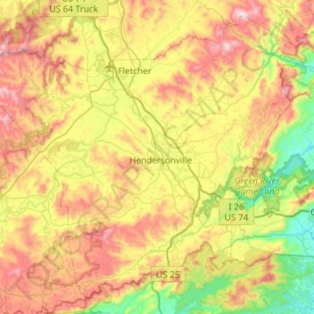
Name: Henderson County topographic map, elevation, terrain.
Location: Henderson County, North Carolina, United States (35.14419 -82.74515 35.50022 -82.26116)
Average elevation: 2,306 ft
Minimum elevation: 906 ft
Maximum elevation: 4,347 ft
North Carolina trails, hiking, mountain biking, running and outdoor activities
Other topographic maps
Click on a map to view its topography, its elevation and its terrain.
Appalachian Mountains
United States > North Carolina > Yancey County
The Appalachian Mountains (French: Appalaches), often called the Appalachians, are a system of mountains in eastern to northeastern North America. The Appalachians first formed roughly 480 million years ago during the Ordovician Period. They once reached elevations similar to those of the Alps and the Rocky…
Average elevation: 4,800 ft
Country Club Estates
United States > North Carolina > Alamance County > Burlington
Average elevation: 640 ft
Highlands
United States > North Carolina > Macon County > Highlands
Highlands was founded in 1875 after its two founders, Samuel Truman Kelsey and Clinton Carter Hutchinson, drew lines from Chicago to Savannah and from New Orleans to New York City. They felt that the place where these lines met would eventually become a great trading center and commercial crossroads. Highlands…
Average elevation: 3,576 ft
Ballantyne's Backyard
United States > North Carolina > Mecklenburg County > Charlotte
Average elevation: 600 ft
Loch Lommond
United States > North Carolina > Cumberland County > Fayetteville
Average elevation: 230 ft
Shadowlawn
United States > North Carolina > Cumberland County > Fayetteville
Average elevation: 187 ft
Hoopers Creek
United States > North Carolina > Henderson County > Fletcher
Average elevation: 2,221 ft
Maplewood
United States > North Carolina > Richmond County > Rockingham > East Rockingham
Average elevation: 272 ft
Shadowlawn
United States > North Carolina > Cumberland County > Fayetteville
Average elevation: 187 ft
Mount Mitchell
United States > North Carolina > Yancey County
Mount Mitchell (Attakulla in Cherokee) is the highest peak of the Appalachian Mountains and the highest peak in mainland North America east of the Mississippi River. It is located near Burnsville in Yancey County, North Carolina in the Black Mountain subrange of the Appalachians about 19 miles (31 km)…
Average elevation: 5,719 ft
Mount Mitchell
United States > North Carolina > Yancey County
Mount Mitchell, known in Cherokee as Attakulla, is the highest peak of the Appalachian Mountains and the highest peak in mainland eastern North America. It is located near Burnsville in Yancey County, North Carolina in the Black Mountain subrange of the Appalachians about 19 miles (31 km) northeast of…
Average elevation: 5,719 ft
Appalachian Ski Mountain Dam
United States > North Carolina > Watauga County
Average elevation: 3,652 ft
Reynolda Village
United States > North Carolina > Forsyth County > Winston-Salem
Average elevation: 912 ft
Tuckaseegee Park
United States > North Carolina > Mecklenburg County > Charlotte
Average elevation: 764 ft
Atwood Acres
United States > North Carolina > Forsyth County > Winston-Salem
Average elevation: 791 ft
Oak Ridge Park
United States > North Carolina > Richmond County > East Rockingham
Average elevation: 279 ft
Hideaway Mountain Lake Dam
United States > North Carolina > Cherokee County
Average elevation: 2,159 ft
Sharon Colony
United States > North Carolina > Mecklenburg County > Charlotte
Average elevation: 659 ft
Wilmington Beach
United States > North Carolina > New Hanover County > Carolina Beach
Average elevation: 7 ft
Appalachian Mountains
United States > North Carolina > Yancey County
The range is older than the other major mountain range in North America, the Rocky Mountains of the west. Some of the outcrops in the Appalachians contain rocks formed during the Precambrian era. The geologic processes that led to the formation of the Appalachian Mountains started 1.1 billion years ago. The…
Average elevation: 4,800 ft
Bald Head Island
United States > North Carolina > Brunswick County > Bald Head Island
Average elevation: 10 ft
Cul Res Town Creek Indian Mound
United States > North Carolina > Montgomery County
Average elevation: 233 ft
Wilmington Beach
United States > North Carolina > New Hanover County > Carolina Beach
Average elevation: 7 ft