
Kolkata topographic map
Interactive map
Click on the map to display elevation.
Kolkata
Spread roughly north–south along the east bank of the Hooghly River, Kolkata sits within the lower Ganges Delta of eastern India approximately 75 km (47 mi) west of the international border with Bangladesh; the city's elevation is 1.5–9 m (5–30 ft).[60] Much of the city was originally a wetland that was reclaimed over the decades to accommodate a burgeoning population.[61] The remaining undeveloped areas, known as the East Kolkata Wetlands, were designated a "wetland of international importance" by the Ramsar Convention (1975).[62] As with most of the Indo-Gangetic Plain, the soil and water are predominantly alluvial in origin. Kolkata is located over the "Bengal basin", a pericratonic tertiary basin.[63] Bengal basin comprises three structural units: shelf or platform in the west; central hinge or shelf/slope break; and deep basinal part in the east and southeast. Kolkata is located atop the western part of the hinge zone which is about 25 km (16 mi) wide at a depth of about 45,000 m (148,000 ft) below the surface.[63] The shelf and hinge zones have many faults, among them some are active. Total thickness of sediment below Kolkata is nearly 7,500 m (24,600 ft) above the crystalline basement; of these the top 350–450 m (1,150–1,480 ft) is Quaternary, followed by 4,500–5,500 m (14,760–18,040 ft) of Tertiary sediments, 500–700 m (1,640–2,300 ft) trap wash of Cretaceous trap and 600–800 m (1,970–2,620 ft) Permian-Carboniferous Gondwana rocks.[63] The quaternary sediments consist of clay, silt and several grades of sand and gravel. These sediments are sandwiched between two clay beds: the lower one at a depth of 250–650 m (820–2,130 ft); the upper one 10–40 m (30–130 ft) in thickness.[64] According to the Bureau of Indian Standards, on a scale ranging from I to V in order of increasing susceptibility to earthquakes, the city lies inside seismic zone III.[65]
About this map
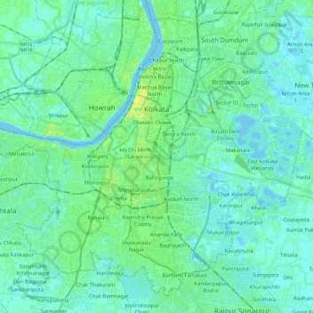
Name: Kolkata topographic map, elevation, terrain.
Location: Kolkata, West Bengal, India (22.45203 88.23363 22.61883 88.46108)
Average elevation: 16 ft
Minimum elevation: -10 ft
Maximum elevation: 75 ft
Other topographic maps
Click on a map to view its topography, its elevation and its terrain.
Kharagpur
India > West Bengal > Kharagpur-I
Kharagpur is the fourth largest city of West Bengal in area after Kolkata, Durgapur and Asansol. It is also the fifth most populated city of West Bengal after Kolkata, Asansol, Siliguri, Durgapur - located at 22°19′49″N 87°19′25″E / 22.330239°N 87.323653°E / 22.330239; 87.323653, covering…
Average elevation: 128 ft
Jaynagar Majilpur
India > West Bengal > Jaynagar - I
Jaynagar Majilpur is located at 22°10′31″N 88°25′12″E / 22.1751976°N 88.4200808°E / 22.1751976; 88.4200808. It has an average elevation of 8 metres (26 ft).
Average elevation: 16 ft
Berhampore
India > West Bengal > Berhampore
Berhampore is located at 24°06′N 88°15′E / 24.1°N 88.25°E / 24.1; 88.25. It has an average elevation of 18 metres (59 feet).
Average elevation: 66 ft
Kolkata
Spread roughly north–south along the east bank of the Hooghly River, Kolkata sits within the lower Ganges Delta of eastern India approximately 75 km (47 mi) west of the international border with Bangladesh; the city's elevation is 1.5–9 m (5–30 ft). Much of the city was originally a wetland that was…
Average elevation: 16 ft
Siliguri
India > West Bengal > Siliguri Subdivsion
Siliguri located at the foothills of the eastern Himalayas at a location of 26°43′N 88°26′E / 26.71°N 88.43°E / 26.71; 88.43. This city is spread over an area of 260 km2 within the Siliguri Corridor, also known as the Chicken's neck. The city is surrounded by dense forests towards north and…
Average elevation: 397 ft
Siliguri
India > West Bengal > Siliguri Subdivsion
Siliguri is located at the foothills of the eastern Himalayas at a location of 26°43′N 88°26′E / 26.71°N 88.43°E / 26.71; 88.43. The city is spread over an area of 260 km2 (100 sq mi) within the Siliguri Corridor, and has earned a moniker the Chicken's neck. The city is surrounded by dense…
Average elevation: 397 ft
Uluberia
India > West Bengal > Uluberia - I
Uluberia is located at 22°28′N 88°07′E / 22.47°N 88.11°E / 22.47; 88.11. It has an average elevation of 1 m (3.3 ft). It is situated on the banks of the river Hooghly. The main road passing through the heart of the city is Orissa trunk road and is also well connected by National Highway 16.…
Average elevation: 16 ft
Singur
India > West Bengal > Singur
Singur is located at 22°49′N 88°14′E / 22.81°N 88.23°E / 22.81; 88.23. It has an average elevation of 14 metres (45 ft), and is situated on the Ganges delta.
Average elevation: 30 ft
Rishyap
India > West Bengal > Kalimpong - II
Rishyap is located at 27.03N & 88.18E. It has an average elevation of 2591 meters (8500 feet).
Average elevation: 5,869 ft
Kharagpur
India > West Bengal > Kharagpur-I
Kharagpur is the fourth largest city of West Bengal in area after Kolkata, Durgapur and Asansol. It is also the fifth most populated city of West Bengal after Kolkata, Asansol, Siliguri, Durgapur - located at 22°19′49″N 87°19′25″E / 22.330239°N 87.323653°E / 22.330239; 87.323653, covering…
Average elevation: 128 ft
Dhupguri
India > West Bengal > Dhupguri
Dhupguri has an average elevation of 80 metres (262 feet), and is a municipality in the Jalpaiguri district. In the foothills of the Bhutanese Himalayas, the Jaldhaka River flows through the west of the town. The Daina, Gilandi, Duduya, Kumlai, Jhumur, and Bamni are other rivers which flow through the town.
Average elevation: 253 ft
Baruipur
India > West Bengal > Baruipur
Baruipur is located at 22°21′56″N 88°25′57″E / 22.3654432°N 88.4325028°E / 22.3654432; 88.4325028. It has an average elevation of 9 metres (30 ft).
Average elevation: 23 ft
Jaynagar Majilpur
India > West Bengal > Jaynagar - I
Jaynagar Majilpur is located at 22°10′31″N 88°25′12″E / 22.1751965°N 88.4200762°E / 22.1751965; 88.4200762. It has an average elevation of 8 metres (26 ft).
Average elevation: 16 ft
Digha
India > West Bengal > Digha
Digha is located at 21°38′18″N 87°30′35″E / 21.6384°N 87.5096°E / 21.6384; 87.5096. It has an average elevation of 6 metres (20 ft).
Average elevation: 13 ft
Lava
India > West Bengal > Kalimpong - II
Lava (also known as Lava Bazar) is a town in the Kalimpong II CD block in the Kalimpong subdivision of the Kalimpong district in the Indian state of West Bengal. As it lies in the high altitude, so it is also visible from high altitude towns and villages of East Sikkim, high areas of Bhutan and also from…
Average elevation: 6,335 ft
Debagram
India > West Bengal > Kaliganj
Debagram is a part of deltaic alluvial plain of west Bengal formed by river Ganga and its tributaries and distributaries. It has an average elevation of 18 meters. This flat area is characterized by some ponds and low lands. The nearest river of the village is the Bhagirathi. It is about 9 km away from the…
Average elevation: 52 ft
Mirik
India > West Bengal > Mirik Subdivision
Mirik has an average elevation of 1,495 m (4,905 ft). The highest point is the Bokar Monastery at about 1,768 m (5,801 ft). Mirik lake at about 1,494 m (4,902 ft) is the lowest point. Mirik is 52 km (32 mi) northwest of Siliguri city and 49 km (30 mi) south-southwest of Darjeeling town. Mirik subdivision. The…
Average elevation: 3,793 ft
Rajpur Sonarpur
India > West Bengal > Sonarpur
Rajpur Sonarpur is located at 22°26′18″N 88°25′55″E / 22.4382026°N 88.4320450°E / 22.4382026; 88.4320450. It has an average elevation of 9 metres (30 ft).
Average elevation: 13 ft
Jhargram
India > West Bengal > Jhargram
Jhargram is located at 22°27′N 86°59′E / 22.45°N 86.98°E / 22.45; 86.98. It has an average elevation of 81 metres (265 feet). The weather, like much of Bengal, is extremely humid and tropical. Temperatures can reach as high as 46 °C in the hot and dry months of May and June but can plummet to…
Average elevation: 259 ft
Kakdwip
India > West Bengal > Kakdwip
Kakdwip is located at 21°52′45″N 88°11′29″E / 21.8791446°N 88.1912992°E / 21.8791446; 88.1912992. It has an average elevation of 4 metres (13 ft).
Average elevation: 10 ft
Malda
India > West Bengal > English Bazar
Malda is located at 25°00′43″N 88°08′36″E / 25.0119°N 88.1433°E / 25.0119; 88.1433. It has an average elevation of 17 metres (56 feet). It is situated on both the western and eastern banks of the river Mahananda.
Average elevation: 85 ft
Beldanga
India > West Bengal > Beldanga - I
Beldanga is located at 23°56′N 88°15′E / 23.93°N 88.25°E / 23.93; 88.25. It has an average elevation of 20 metres (65 feet).
Average elevation: 56 ft
Bangaon
India > West Bengal > Bongaon
Bangaon is located at 23°04′N 88°49′E / 23.07°N 88.82°E / 23.07; 88.82. It has an average elevation of 7 metres (22 feet). Arsenic contamination is a major concern in this area.
Average elevation: 23 ft
Taki
India > West Bengal > Hasnabad
Taki is located at 22°35′N 88°55′E / 22.59°N 88.92°E / 22.59; 88.92. It has an average elevation of 5 metres (16 feet) at the bank of Ichamati River.
Average elevation: 13 ft
Kharagpur
India > West Bengal > Kharagpur-I
Kharagpur is the fourth largest city of West Bengal in area after Kolkata, Durgapur and Asansol. It is also the fifth most populated city of West Bengal after Kolkata, Asansol, Siliguri, Durgapur - located at 22°19′49″N 87°19′25″E / 22.330239°N 87.323653°E / 22.330239; 87.323653, covering…
Average elevation: 128 ft
Bidhannagar
India > West Bengal > Bidhannagar
According to the Bidhannagar Municipal Corporation, the city area has a total area of 55.51 square kilometres (21.43 sq mi), with approx 30.51 square kilometres (11.78 sq mi) of it being land, and approx 25 square kilometres (9.7 sq mi), or 45.5% of the total, being covered by water. It has an average…
Average elevation: 16 ft
Cooch Behar
India > West Bengal > Cooch Behar
The elevation of the town is 48 meters above mean sea level.
Average elevation: 141 ft
Krishnanagar
India > West Bengal > Krishnagar-I
Krishnanagar is located at 23°24′N 88°30′E / 23.4°N 88.5°E / 23.4; 88.5. The area of the municipality is around 16 km2. It is situated on the southern banks of the Jalangi River. It has an average elevation of 14 metres (46 ft). The Tropic of Cancer passes through the outskirts of…
Average elevation: 36 ft
Dum Dum
India > West Bengal > Barrackpore
Dum Dum is located at 22°37′N 88°25′E / 22.62°N 88.42°E / 22.62; 88.42. It has an average elevation of 11 metres (36 feet).
Average elevation: 20 ft
Damdim
India > West Bengal > Mal
Dam Dim is located at 26°51′56″N 88°40′11″E / 26.8656°N 88.6698°E / 26.8656; 88.6698 at an elevation of 141 m above MSL.
Average elevation: 528 ft
Karimpur
India > West Bengal > Karimpur-I
Karimpur is located at 23°58′N 88°37′E / 23.97°N 88.62°E / 23.97; 88.62. It has an average elevation of 15 metres (49 ft). It is 183 km (114 mi) from Kolkata and is located at the bank of the River Jalangi.
Average elevation: 59 ft
Barasat
India > West Bengal > Barasat - I
Its average elevation is 11 metres (36 ft). The nearest river is the Ganges, about 15 kilometres (9.3 mi) to the west, and it is on the Gangetic plain.
Average elevation: 20 ft
Bidhannagar
India > West Bengal > Bidhannagar
Bidhannagar is located at 22°35′N 88°25′E / 22.58°N 88.42°E / 22.58; 88.42. It has an average elevation of 11 metres (49 ft).
Average elevation: 16 ft
Haldia
India > West Bengal > Haldia
Haldia is located at 22°02′N 88°04′E / 22.03°N 88.06°E / 22.03; 88.06. It has an average elevation of 8 metres (26 ft).
Average elevation: 10 ft
Diamond Harbour
India > West Bengal > Diamond Harbour - I
Diamond Harbour is located at 22°11′28″N 88°11′26″E / 22.1910091°N 88.1904741°E / 22.1910091; 88.1904741. It has an average elevation of 8 metres (26 ft).
Average elevation: 10 ft
Dankuni
India > West Bengal > Chanditala - II
Located at an elevation of None meters (0 feet) above sea level, city's yearly temperature is 30.28 °C (86.5 °F) and it is 4.31% higher than India's averages. Dankuni typically receives about 150.21 millimeters (5.91 inches) of precipitation and has 150.54 rainy days (41.24% of the time) annually.
Average elevation: 20 ft
Chakdaha
India > West Bengal > Chakdaha
Chakdaha is a prominent urban local body in the district of Nadia, one of the southern districts of West Bengal. Chakdaha's location is 23°05′N 88°31′E / 23.08°N 88.52°E / 23.08; 88.52. It has an average elevation of 11 meters (36 feet) and is 62 km north of the state capital, Kolkata. It is…
Average elevation: 33 ft
Purulia
India > West Bengal > Purulia - II
Purulia is located at 23°20′N 86°22′E / 23.33°N 86.37°E / 23.33; 86.37. It has an average elevation of 228 metres (748 feet).
Average elevation: 791 ft