
Make a donation
Gear up for your next adventure:
As an Amazon Associate, this site earns from qualifying purchases at no extra cost to you.
Pine Valley topographic map
Click on the map to display elevation.
Make a donation
Gear up for your next adventure:
As an Amazon Associate, this site earns from qualifying purchases at no extra cost to you.
Pine Valley
According to the United States Geological Survey, Pine Valley is located 3,736 feet (1,139 m) above sea level, at 32°49′17″N 116°31′45″W / 32.82139°N 116.52917°W / 32.82139; -116.52917. Interstate 8 passes east-to-west along the southern border of Pine Valley. It crosses the Pine Valley Creek Bridge to the west of the town, and crosses Laguna Summit (altitude 4,055 feet (1,236 m)) just to the east of the town. The Sunrise Highway marks the eastern border of the town.
Make a donation
Gear up for your next adventure:
As an Amazon Associate, this site earns from qualifying purchases at no extra cost to you.
About this map
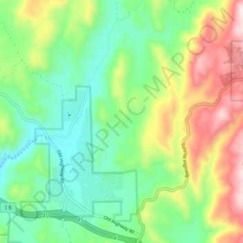
Name: Pine Valley topographic map, elevation, terrain.
Location: Pine Valley, California, 91962, United States (32.81128 -116.53964 32.87233 -116.47967)
Average elevation: 4,236 ft
Minimum elevation: 3,550 ft
Maximum elevation: 5,492 ft
California trails, hiking, mountain biking, running and outdoor activities
Make a donation
Gear up for your next adventure:
As an Amazon Associate, this site earns from qualifying purchases at no extra cost to you.
Other topographic maps
Click on a map to view its topography, its elevation and its terrain.
Twentynine Palms
United States > California > Twentynine Palms
According to the United States Census Bureau, the city has a total area of 59.1 square miles (153 km2), all land. The city is at an elevation of 1,988 feet (606 m). The Marine Corps Air Ground Combat Center Twentynine Palms is located there.
Average elevation: 2,264 ft
Placerville
United States > California > Placerville
The region east of Placerville, popularly known as Apple Hill and Pleasant Valley, is becoming a center for wine production. The wine region is officially designated as the El Dorado AVA. The largest wineries in the area are Boeger, Lava Cap and Madrona, but most of the 30 plus wineries surrounding Placerville…
Average elevation: 1,926 ft
San Diego
United States > California > San Diego County > San Diego
The climate in San Diego, like most of Southern California, often varies significantly over short geographical distances, resulting in microclimates. In San Diego, this is mostly because of the city's topography (the Bay, and the numerous hills, mountains, and canyons). Frequently, particularly during the "May…
Average elevation: 187 ft
Make a donation
Gear up for your next adventure:
As an Amazon Associate, this site earns from qualifying purchases at no extra cost to you.
Make a donation
Gear up for your next adventure:
As an Amazon Associate, this site earns from qualifying purchases at no extra cost to you.
Lodi
United States > California > San Joaquin County
Lodi is flat terrain at an elevation of approximately 50 feet (15 m) above mean sea level datum. Historically, land in the area has been used for grazing as well as for grain production.
Average elevation: 10 ft
La Jolla
United States > California > San Diego County > San Diego > La Jolla
Average elevation: 121 ft
Fort Irwin
United States > California > San Bernardino County
Fort Irwin National Training Center (Fort Irwin NTC) is a major training area for the United States military in the Mojave Desert in northern San Bernardino County, California. Fort Irwin is at an average elevation of 2,454 feet (748 m). It is located 37 miles (60 km) northeast of Barstow, in the Calico…
Average elevation: 2,539 ft
Yosemite Valley
United States > California > Mariposa County > Yosemite Village > Yosemite Lodge
Average elevation: 4,852 ft
Make a donation
Gear up for your next adventure:
As an Amazon Associate, this site earns from qualifying purchases at no extra cost to you.
Horseshoe Lake
United States > California > Alameda County > Fremont > Eberly
Average elevation: 75 ft
Make a donation
Gear up for your next adventure:
As an Amazon Associate, this site earns from qualifying purchases at no extra cost to you.
Pine Valley
United States > California > San Diego County
Pine Valley is named for the locally unique strand of Jeffrey pine (Pinus jeffreyi) found along Pine Valley Creek, a seasonal drainage in the foothills of the Laguna Mountains in central San Diego County. According to the United States Geological Survey, Pine Valley is located 3,736 feet (1,139 m) above sea…
Average elevation: 4,236 ft
Capitola
United States > California > Santa Cruz County > Capitola > Capitola
Average elevation: 128 ft
San Gorgonio Pass
United States > California > Riverside County
The San Gorgonio Pass, or Banning Pass, is a 2,600 ft (790 m) elevation gap on the rim of the Great Basin between the San Bernardino Mountains to the north and the San Jacinto Mountains to the south. The pass was formed by the San Andreas Fault, a major transform fault between the Pacific plate and the North…
Average elevation: 1,614 ft
Make a donation
Gear up for your next adventure:
As an Amazon Associate, this site earns from qualifying purchases at no extra cost to you.
Mariposa
United States > California > Mariposa County > Mariposa
Mariposa is located at 37°29′06″N 119°57′59″W / 37.48500°N 119.96639°W / 37.48500; -119.96639, at 1,949 feet (594 m) in elevation. It lies in the rugged foothills of the Sierra Nevada. Mariposa Creek flows through the town. Soils in the urban area are mostly brown to reddish brown loam of…
Average elevation: 2,251 ft
Fort Bragg
United States > California > Mendocino County
Fort Bragg, officially the City of Fort Bragg, is a city along the Pacific Coast of California along Shoreline Highway in Mendocino County. The city is 24 miles (39 km) west of Willits, at an elevation of 85 feet (26 m). Its population was 6,983 at the 2020 census.
Average elevation: 26 ft
Make a donation
Gear up for your next adventure:
As an Amazon Associate, this site earns from qualifying purchases at no extra cost to you.
El Dorado
United States > California > El Dorado County
El Dorado (Spanish for "The Golden") is an unincorporated community in El Dorado County, California. It is located 4 miles (6.4 km) southwest of Placerville, at an elevation of 1608 feet (490 m). The population was 4,096 at the 2000 census. The town is registered as California Historical Landmark #486. The ZIP…
Average elevation: 1,677 ft
Cameron Park
United States > California > El Dorado County
Cameron Park is situated in an interior chaparral zone or brush zone just east of the Central Valley. It is the closest population center to the Pine Hill Ecological Reserve. Native vegetation includes an abundance of redbud and manzanita bushes, and brush in general. Where treed the native trees are primarily…
Average elevation: 1,280 ft
Hemet
United States > California > Hemet
Dedicated to James Simpson, Hemet City Council 1947–48, and mayor 1950 to 1966. Simpson Park is a wilderness park located in the Santa Rosa Hills southeast of Hemet with sheltered picnic area and tables, barbecues, restrooms, and hiking trails. At an elevation of 2,500 feet (760 m), it provides an expansive…
Average elevation: 1,667 ft
Make a donation
Gear up for your next adventure:
As an Amazon Associate, this site earns from qualifying purchases at no extra cost to you.
Make a donation
Gear up for your next adventure:
As an Amazon Associate, this site earns from qualifying purchases at no extra cost to you.
Make a donation
Gear up for your next adventure:
As an Amazon Associate, this site earns from qualifying purchases at no extra cost to you.
Make a donation
Gear up for your next adventure:
As an Amazon Associate, this site earns from qualifying purchases at no extra cost to you.
Make a donation
Gear up for your next adventure:
As an Amazon Associate, this site earns from qualifying purchases at no extra cost to you.
Independence
Independence is a census-designated place in Inyo County, California. Independence is located 41 miles (66 km) south-southeast of Bishop, at an elevation of 3930 feet (1198 m). It is the county seat of Inyo County, California. The population of this census-designated place was 669 at the 2010 census, up from…
Average elevation: 3,934 ft
Make a donation
Gear up for your next adventure:
As an Amazon Associate, this site earns from qualifying purchases at no extra cost to you.
Make a donation
Gear up for your next adventure:
As an Amazon Associate, this site earns from qualifying purchases at no extra cost to you.
Make a donation
Gear up for your next adventure:
As an Amazon Associate, this site earns from qualifying purchases at no extra cost to you.
Make a donation
Gear up for your next adventure:
As an Amazon Associate, this site earns from qualifying purchases at no extra cost to you.
Make a donation
Gear up for your next adventure:
As an Amazon Associate, this site earns from qualifying purchases at no extra cost to you.
Make a donation
Gear up for your next adventure:
As an Amazon Associate, this site earns from qualifying purchases at no extra cost to you.
Rancho Santa Fe
The climate of Rancho Santa Fe is, for the most part, typical of the San Diego metropolitan area though its higher elevation and inland location lends itself to larger temperature variations.
Average elevation: 203 ft
Make a donation
Gear up for your next adventure:
As an Amazon Associate, this site earns from qualifying purchases at no extra cost to you.
Susanville
United States > California > Lassen County
Susanville (formerly known as Rooptown) is a town in and is the county seat of Lassen County, California, United States. Susanville is located on the Susan River in the southern part of the county, at an elevation of 4,186 feet (1,276 m). Its population is 16,728 as of the 2020 census, down from 17,947 from…
Average elevation: 4,413 ft
Lancaster
United States > California > Lancaster
According to the United States Census Bureau, the city has a total area of 94.5 square miles (245 km2), of which 94.3 square miles (244 km2) is land and 0.3 square miles (0.78 km2) (0.29%) is water. Lancaster's elevation is 2,350 feet (720 m) above sea level on a high, flat valley surrounded by pristine…
Average elevation: 2,582 ft
Make a donation
Gear up for your next adventure:
As an Amazon Associate, this site earns from qualifying purchases at no extra cost to you.
Idyllwild-Pine Cove
United States > California > Riverside County
"Mile-high Idyllwild" is a mountain resort about one-mile (1,600 m) in altitude. Idyllwild is flanked by two large rock formations, Tahquitz Peak and Suicide Rock (also known as Lily Rock), which are famous in Southern California rock-climbing circles. It offers no skiing, so "the Hill" has been minimally…
Average elevation: 5,728 ft
Make a donation
Gear up for your next adventure:
As an Amazon Associate, this site earns from qualifying purchases at no extra cost to you.
Sebastopol
United States > California > Sonoma County
Sebastopol's elevation is 65 to 250 feet (20 to 76 meters) above sea level. Its downtown is at the intersection of State Route 12 and State Route 116 (Gravenstein Highway), approximately 9 mi (14 km) west of U.S. Route 101.
Average elevation: 226 ft
Make a donation
Gear up for your next adventure:
As an Amazon Associate, this site earns from qualifying purchases at no extra cost to you.
Pollock Pines
United States > California > El Dorado County
Pollock Pines is a census-designated place (CDP) in El Dorado County, California, United States. It is part of the Sacramento–Arden-Arcade–Roseville Metropolitan Statistical Area. Pollock Pines lies at an elevation of 3,980 feet (1,210 m) in the Sierra Nevada. The population was 6,871 at the 2010 census,…
Average elevation: 3,681 ft
Crescent City
United States > California > Del Norte County
The topography of the sea floor surrounding Crescent City has the effect of focusing tsunamis. According to researchers at Humboldt State University and the University of Southern California, the city experienced tsunami conditions 31 times between the years 1933 and 2008. Although many of these incidents were…
Average elevation: 20 ft
Make a donation
Gear up for your next adventure:
As an Amazon Associate, this site earns from qualifying purchases at no extra cost to you.
Gilroy
United States > California > Santa Clara County > Gilroy
Gilroy is approximately 16 miles (26 km) south of San Jose, California (Bailey Avenue (37.206770, -121.729150) to Monterey/Day Road (37.038210, -121.584480)) on U.S. Route 101 and 19 miles (31 km) inland from the Pacific Coast. Despite its apparent close proximity to San Jose, it is important to note that…
Average elevation: 715 ft
Bakersfield
United States > California > Kern County > Bakersfield
Most of Bakersfield’s major streets are six-lane divided roads with bike lanes, with almost every street in the city having proper lane signage for bicycle traffic. Bikes are a popular method of transportation in Bakersfield, due to the city’s relatively flat topography and grid-like street system. Newer…
Average elevation: 528 ft
Kernville
United States > California > Kern County > Kernville
Kernville is a census-designated place (CDP) in the southern Sierra Nevada, in Kern County, California, United States. Kernville is located 42 miles (68 km) northeast of Bakersfield, at an elevation of 2,667 feet (813 m). The population was 1,549 at the 2020 United States census, up from 1,395 at the 2010…
Average elevation: 3,724 ft
Make a donation
Gear up for your next adventure:
As an Amazon Associate, this site earns from qualifying purchases at no extra cost to you.
Solvang
United States > California > Santa Barbara County
Solvang is located at 34°35′38″N 120°8′23″W / 34.59389°N 120.13972°W / 34.59389; -120.13972. At an elevation of 505 ft (154 m), it lies in the Santa Ynez Valley some 46 miles (74 km) north-west of Santa Barbara and about 15 miles (24 km) north of the Pacific coast. According to the United…
Average elevation: 636 ft
Rescue
United States > California > El Dorado County
Rescue, formerly Green Valley, El Dorado County, California, is an unincorporated community in El Dorado County, California. It is located north-northwest of Shingle Springs and north-northeast of Cameron Park. The zip code is 95672, and Rescue is located in area code 530. The town lies at an elevation of 1214…
Average elevation: 1,289 ft
Make a donation
Gear up for your next adventure:
As an Amazon Associate, this site earns from qualifying purchases at no extra cost to you.
Stallion Springs
United States > California > Kern County > Stallion Springs
Average elevation: 3,927 ft
Bradley
United States > California > Monterey County
Bradley is an unincorporated community and census-designated place (CDP) in Monterey County, California, on the Salinas River 14 miles (23 km) south-southeast of San Ardo and 20 miles (32 km) north of Paso Robles. Bradley sits at an elevation of 548 feet (167 m). The population was 69 at the 2020 census, down…
Average elevation: 623 ft
Klamath
United States > California > Del Norte County
Klamath (Tolowa: Taa-chit) is an unincorporated, rural census-designated place (CDP) in Del Norte County, California, situated on US Route 101 inland from the mouth of the Klamath River. The current population of Klamath, California is 632 based on US Census estimates, down from 779 recorded in the 2010 US…
Average elevation: 623 ft
Make a donation
Gear up for your next adventure:
As an Amazon Associate, this site earns from qualifying purchases at no extra cost to you.