Geolocate

Harris County topographic map

Interactive map

Click on the map to display elevation.

About this map

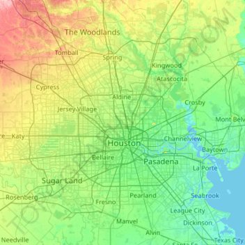
Name: Harris County topographic map, elevation, terrain.

Location: Harris County, Texas, United States (29.49734 -95.96085 30.17073 -94.90849)

Average elevation: 92 ft

Minimum elevation: -10 ft

Maximum elevation: 413 ft

Routes: Texas GPS tracks, routes, trails, hikes

Other topographic maps

Click on a map to view its topography, its elevation and its terrain.

Austin

United States > Texas > Travis County

Austin features a diverse and varied topography shaped by its position along the Balcones Fault. The city’s elevation ranges from about 425 feet to approximately 1,000 feet above sea level, creating a landscape characterized by rolling hills and elevated areas particularly in the western regions. To the…

Average elevation: 709 ft

Dallas

United States > Texas > Dallas County

Dallas features a predominantly flat terrain characterized by elevations generally ranging from 450 to 550 feet (137 to 168 meters) above sea level. The landscape is shaped significantly by the western edge of the Austin Chalk Formation, a limestone escarpment known as the White Rock Escarpment, which rises…

Average elevation: 525 ft

San Antonio

United States > Texas > Bexar County

San Antonio features a diverse topography characterized by gently rolling hills and flat plains. The city's elevation averages around 650 feet above sea level, but nearby areas can reach heights of up to 1,300 feet in certain locations like Cross Mountain​. The landscape is part of the southern edge of the…

Average elevation: 810 ft

Montgomery County

United States > Texas

Average elevation: 226 ft

El Paso

United States > Texas > El Paso County

El Paso County was established in March 1850, with San Elizario as the first county seat. The United States Senate fixed a boundary between Texas and New Mexico at the 32nd parallel, thus largely ignoring history and topography. A military post called the "Post opposite El Paso" (meaning opposite El Paso del…

Average elevation: 4,058 ft

Houston

United States > Texas > Harris County

Houston is characterized by its predominantly flat topography, sitting at an average elevation of approximately 59 feet (18 meters) above sea level. The city is situated on the Gulf Coastal Plain, which is dissected by a network of bayous that contribute to the region's drainage. This terrain was once covered…

Average elevation: 82 ft

Laredo

United States > Texas > Webb County

Average elevation: 525 ft

San Marcos

United States > Texas > Hays County

San Marcos is characterized by its diverse topography, which includes rolling hills, lush riverbanks, and scenic limestone outcroppings. The city is situated at an elevation of approximately 600 feet above sea level, providing a backdrop of gently undulating terrain that slopes towards the banks of the San…

Average elevation: 682 ft

Denton

United States > Texas > Denton County

Denton is on the northern edge of the Dallas–Fort Worth metropolitan area. These three cities form the area known as the "Golden Triangle of North Texas". According to the United States Census Bureau, the city has an area of 89.316 square miles (231.33 km2), of which 87.952 square miles (227.79 km2) is land…

Average elevation: 640 ft

Fort Worth

United States > Texas > Tarrant County

Average elevation: 696 ft

Beaumont

United States > Texas > Jefferson County

Average elevation: 20 ft

Conroe

United States > Texas > Montgomery County

Conroe features a predominantly flat terrain with an average elevation of approximately 220 feet (67 meters) above sea level. The area is characterized by gently rolling hills interspersed with numerous lakes and wetlands, including the prominent Lake Conroe, which spans about 21,000 acres. The lake, formed by…

Average elevation: 203 ft

Port Arthur

United States > Texas > Jefferson County

Average elevation: 7 ft

Corpus Christi

United States > Texas > Nueces County

Corpus Christi features a diverse coastal topography characterized by its proximity to the Gulf of Mexico. The landscape includes sandy beaches, barrier islands, and extensive estuarine systems such as the Nueces Estuary and Corpus Christi Bay, which are crucial habitats for wildlife. The region is…

Average elevation: 26 ft

Baytown

United States > Texas > Harris County

Average elevation: 23 ft

Culberson County

United States > Texas

Prehistoric Clovis culture peoples in Culberson County lived in the rock shelters and caves nestled near water supplies. These people left behind artifacts and pictographs as evidence of their presence. With its treacherous topography, the area remained untouched by white explorations for centuries.

Average elevation: 4,111 ft

Lake Travis

United States > Texas > Travis County > Lago Vista

Average elevation: 912 ft

Williamson County

United States > Texas

The area is divided into two regions by the Balcones Escarpment, which runs through the center from north to south along a line from Jarrell to Georgetown to Round Rock. The county's western half is an extension of the Western Plains and considered to be within the eastern fringes of Texas Hill Country; it has…

Average elevation: 728 ft

Pflugerville

United States > Texas > Travis County

Average elevation: 705 ft

Travis County

United States > Texas

Travis County features a varied and dynamic topography characterized by rolling hills, lush valleys, and significant water features. The terrain rises gently from the flatlands in the east to the more rugged and elevated areas in the west, reaching elevations of up to about 1,400 feet above sea level. The…

Average elevation: 758 ft

Weatherford

United States > Texas > Parker County

Average elevation: 1,070 ft

Hunt County

United States > Texas

Average elevation: 548 ft

Bastrop County

United States > Texas

Average elevation: 489 ft

Bexar County

United States > Texas

Average elevation: 820 ft

League City

United States > Texas > Galveston County

Average elevation: 23 ft

Granbury

United States > Texas > Hood County

Average elevation: 794 ft

Plano

United States > Texas > Collin County

At first, Plano's population grew slowly, reaching 1,304 in 1900 and 3,695 in 1960. By 1970, Plano began to feel some of the boom its neighbors had experienced after World War II. A series of public works projects and a change in taxes that removed the farming community from the town helped increase the…

Average elevation: 643 ft

Kerrville

United States > Texas > Kerr County

Average elevation: 1,788 ft

McAllen

United States > Texas > Hidalgo County

Average elevation: 131 ft

Abilene

United States > Texas > Taylor County

Average elevation: 1,749 ft

Killeen

United States > Texas > Bell County

Average elevation: 873 ft

Wichita Falls

United States > Texas > Wichita County

Average elevation: 984 ft

Amarillo

United States > Texas > Potter County

Amarillo features a unique topography characterized by its high elevation and flat plains. The city averages around 3,600 feet (1,097 meters) above sea level, making it one of the highest major cities in Texas​. The surrounding landscape consists of the Llano Estacado, a vast tabletop plateau that slopes…

Average elevation: 3,599 ft

Liberty County

United States > Texas

Average elevation: 82 ft

Orange County

United States > Texas

The geography of Orange County varies relatively little, with an elevation that reaches 33 ft (10 m) above sea level at very few points within the county. Orange County is very flat, and its soil is quite sandy, as could be expected in a county along the Gulf of Mexico. (Sandy soil is also common in southern…

Average elevation: 13 ft

Smith County

United States > Texas

Average elevation: 430 ft

Hagansport

United States > Texas > Franklin County

Average elevation: 371 ft

Moonshine Hill

United States > Texas > Harris County > Houston

Average elevation: 72 ft

Kingwood

United States > Texas > Harris County > Houston

Average elevation: 72 ft

McLennan County

United States > Texas

Average elevation: 594 ft

Comal County

United States > Texas

Average elevation: 1,020 ft

Rockport

United States > Texas > Aransas County

Average elevation: 10 ft

New Braunfels

United States > Texas > Comal County

Average elevation: 748 ft

Cypress

United States > Texas > Harris County

Average elevation: 151 ft

Dripping Springs

United States > Texas > Hays County

Average elevation: 1,168 ft

Frisco

United States > Texas > Collin County

In 1902, a line of the St. Louis-San Francisco Railway was being built through the area, and periodic watering stops were needed along the route for the steam locomotives. The current settlement of Lebanon was on the Preston Ridge, and was too high in elevation, so the watering stop was placed about 4 miles (6…

Average elevation: 659 ft

McKinney

United States > Texas > Collin County

Average elevation: 633 ft

Arlington

United States > Texas > Tarrant County

Average elevation: 571 ft