
Make a donation
Gear up for your next adventure:
As an Amazon Associate, this site earns from qualifying purchases at no extra cost to you.
Ariana topographic map
Click on the map to display elevation.
Make a donation
Gear up for your next adventure:
As an Amazon Associate, this site earns from qualifying purchases at no extra cost to you.
About this map
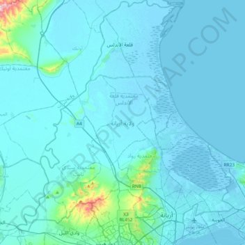
Name: Ariana topographic map, elevation, terrain.
Location: Ariana, Tunisia (36.82196 9.96329 37.11516 10.28874)
Average elevation: 75 ft
Minimum elevation: -23 ft
Maximum elevation: 1,352 ft
Make a donation
Gear up for your next adventure:
As an Amazon Associate, this site earns from qualifying purchases at no extra cost to you.
Other topographic maps
Click on a map to view its topography, its elevation and its terrain.
Carthage
The elevation of the land at the promontory on the seashore to the north-east (now called Sidi Bou Saïd), was twice as high above sea level as that at the Byrsa (100 m and 50 m). In between runs a ridge, several times reaching 50 m; it continues northwestward along the seashore, and forms the edge of a…
Average elevation: 30 ft
Make a donation
Gear up for your next adventure:
As an Amazon Associate, this site earns from qualifying purchases at no extra cost to you.
Make a donation
Gear up for your next adventure:
As an Amazon Associate, this site earns from qualifying purchases at no extra cost to you.
Make a donation
Gear up for your next adventure:
As an Amazon Associate, this site earns from qualifying purchases at no extra cost to you.
Make a donation
Gear up for your next adventure:
As an Amazon Associate, this site earns from qualifying purchases at no extra cost to you.
Kesra
Kesra is a town and commune in the Siliana Governorate, Tunisia. As of 2004 it had a population of 2,490. In 2014 this was 2,600. Kesra is in Siliana Governorate near Maktar at 35.8N and 9.36e. The town is at altitude of 966m and is near the Jebel Serj national park. During the Roman Empire Kesra was a civitas…
Average elevation: 3,074 ft
Make a donation
Gear up for your next adventure:
As an Amazon Associate, this site earns from qualifying purchases at no extra cost to you.
Grombalia
Tunisia > Nabeul > قرنبالية الشرقية
Grombalia is located at an elevation of 102 meters above sea level and spans an area of 815.5 hectares. Its Latin name, "Hukulumbarros," translates to "traveling pigeon." Notably, Grombalia is characterized by its fertile lands and strategic geographical position in Cap Bon, making it a significant gateway to…
Average elevation: 197 ft
Make a donation
Gear up for your next adventure:
As an Amazon Associate, this site earns from qualifying purchases at no extra cost to you.
Make a donation
Gear up for your next adventure:
As an Amazon Associate, this site earns from qualifying purchases at no extra cost to you.
Make a donation
Gear up for your next adventure:
As an Amazon Associate, this site earns from qualifying purchases at no extra cost to you.
Make a donation
Gear up for your next adventure:
As an Amazon Associate, this site earns from qualifying purchases at no extra cost to you.
El Hamma
Located along the Gabès-Kébili road, and at an altitude of about fifty meters, the town borders the Chott el-Fejej. It is one of the natural outlets of the great Albian Aquifer. The oasis has several sources which together form the El Hamma ouads which are 300 meters from each other. Among these are Aïn El…
Average elevation: 243 ft
Make a donation
Gear up for your next adventure:
As an Amazon Associate, this site earns from qualifying purchases at no extra cost to you.
Make a donation
Gear up for your next adventure:
As an Amazon Associate, this site earns from qualifying purchases at no extra cost to you.
Make a donation
Gear up for your next adventure:
As an Amazon Associate, this site earns from qualifying purchases at no extra cost to you.
Make a donation
Gear up for your next adventure:
As an Amazon Associate, this site earns from qualifying purchases at no extra cost to you.
Make a donation
Gear up for your next adventure:
As an Amazon Associate, this site earns from qualifying purchases at no extra cost to you.
Aïn Draham
Tunisia > Jendouba > عين دراهم الأحواز
The city is the capital of a delegation of 40,372 inhabitants. The city itself has an estimated population of 10,843 inhabitants (according to the census of 2004). It is located at an altitude of 800 meters on the slopes of the Djebel Bir (1014 m), one of the Kroumirie mountains. The city is located in one of…
Average elevation: 1,883 ft
Make a donation
Gear up for your next adventure:
As an Amazon Associate, this site earns from qualifying purchases at no extra cost to you.
Make a donation
Gear up for your next adventure:
As an Amazon Associate, this site earns from qualifying purchases at no extra cost to you.
Make a donation
Gear up for your next adventure:
As an Amazon Associate, this site earns from qualifying purchases at no extra cost to you.
Make a donation
Gear up for your next adventure:
As an Amazon Associate, this site earns from qualifying purchases at no extra cost to you.
Carthage
The elevation of the land at the promontory on the seashore to the north-east (now called Sidi Bou Saïd), was twice as high above sea level as that at the Byrsa (100 m and 50 m). In between runs a ridge, several times reaching 50 m; it continues northwestward along the seashore, and forms the edge of a…
Average elevation: 30 ft
Make a donation
Gear up for your next adventure:
As an Amazon Associate, this site earns from qualifying purchases at no extra cost to you.
Make a donation
Gear up for your next adventure:
As an Amazon Associate, this site earns from qualifying purchases at no extra cost to you.
Make a donation
Gear up for your next adventure:
As an Amazon Associate, this site earns from qualifying purchases at no extra cost to you.
Make a donation
Gear up for your next adventure:
As an Amazon Associate, this site earns from qualifying purchases at no extra cost to you.
Bizerte
Tunisia > Bizerte > بوبكر باكير
The bridge leads to the motorway A4 leading to Tunis–Carthage International Airport and the capital. On the town side the P11 passes semi-rural Louata, hugs Ichkeul Lake and branches into a western route, the P7, leading directly to Tabarka on the coast next to the Algerian border. The P11 leads south-west…
Average elevation: 92 ft
Medina of Tunis
In the case of domestic architecture, the more a building is set back from the shops, the more it is valued. The concept of withdrawal and privacy is paramount. The late introduction of a sewer system means that much waste water still flows through the streets of the Medina. The largest houses and noble places…
Average elevation: 52 ft
Make a donation
Gear up for your next adventure:
As an Amazon Associate, this site earns from qualifying purchases at no extra cost to you.