
嫩江镇 topographic map
Interactive map
Click on the map to display elevation.
About this map
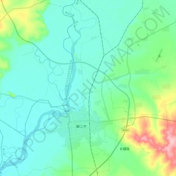
Name: 嫩江镇 topographic map, elevation, terrain.
Location: 嫩江镇, 嫩江县, 黑河市, 黑龙江省, 164300, 中国 (49.12887 125.11709 49.28582 125.35190)
Average elevation: 797 ft
Minimum elevation: 699 ft
Maximum elevation: 1,184 ft
Other topographic maps
Click on a map to view its topography, its elevation and its terrain.