
Hengsen topographic map
Interactive map
Click on the map to display elevation.
About this map
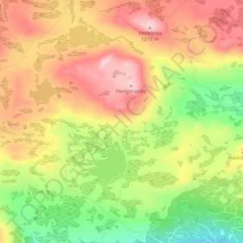
Name: Hengsen topographic map, elevation, terrain.
Location: Hengsen, Ål, Viken, Norwegen (60.71869 8.39716 60.75869 8.43716)
Average elevation: 3,537 ft
Minimum elevation: 3,104 ft
Maximum elevation: 3,950 ft
Other topographic maps
Click on a map to view its topography, its elevation and its terrain.
Hammern
Norwegen > Viken > Fredrikstad > Torsnes
Hammern, Torsnes, Fredrikstad, Viken, Norwegen
Average elevation: 98 ft