
Rødberg topographic map
Interactive map
Click on the map to display elevation.
About this map
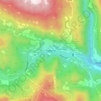
Name: Rødberg topographic map, elevation, terrain.
Location: Rødberg, Nore og Uvdal, Viken, 3630, Norwegen (60.24719 8.92754 60.28719 8.96754)
Average elevation: 1,995 ft
Minimum elevation: 974 ft
Maximum elevation: 3,550 ft
Other topographic maps
Click on a map to view its topography, its elevation and its terrain.
Hammern
Norwegen > Viken > Fredrikstad > Torsnes
Hammern, Torsnes, Fredrikstad, Viken, Norwegen
Average elevation: 98 ft