
Rotnes topographic map
Interactive map
Click on the map to display elevation.
About this map
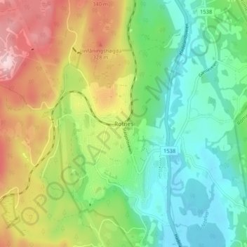
Name: Rotnes topographic map, elevation, terrain.
Location: Rotnes, Nittedal, Viken, 1482, Norwegen (60.03832 10.84756 60.07832 10.88756)
Average elevation: 686 ft
Minimum elevation: 344 ft
Maximum elevation: 1,276 ft
Other topographic maps
Click on a map to view its topography, its elevation and its terrain.
Hammern
Norwegen > Viken > Fredrikstad > Torsnes
Hammern, Torsnes, Fredrikstad, Viken, Norwegen
Average elevation: 98 ft