
Østerås topographic map
Interactive map
Click on the map to display elevation.
About this map
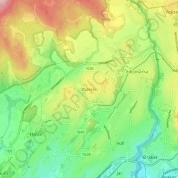
Name: Østerås topographic map, elevation, terrain.
Location: Østerås, Bærum, Viken, 1361, Norwegen (59.92296 10.58438 59.96296 10.62438)
Average elevation: 433 ft
Minimum elevation: 128 ft
Maximum elevation: 883 ft
Other topographic maps
Click on a map to view its topography, its elevation and its terrain.
Hammern
Norwegen > Viken > Fredrikstad > Torsnes
Hammern, Torsnes, Fredrikstad, Viken, Norwegen
Average elevation: 98 ft