
Make a donation
Gear up for your next adventure:
As an Amazon Associate, this site earns from qualifying purchases at no extra cost to you.
Hechtel topographic map
Click on the map to display elevation.
Make a donation
Gear up for your next adventure:
As an Amazon Associate, this site earns from qualifying purchases at no extra cost to you.
About this map
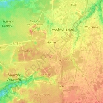
Name: Hechtel topographic map, elevation, terrain.
Average elevation: 203 ft
Minimum elevation: 128 ft
Maximum elevation: 246 ft
Make a donation
Gear up for your next adventure:
As an Amazon Associate, this site earns from qualifying purchases at no extra cost to you.
Other topographic maps
Click on a map to view its topography, its elevation and its terrain.
Make a donation
Gear up for your next adventure:
As an Amazon Associate, this site earns from qualifying purchases at no extra cost to you.
Waterloos
België > Limburg > Maaseik > Maaseik > Neeroeteren
Het gehucht ligt op het overgangsgebied van de Vlakte van Bocholt en het Kempens Plateau op een hoogte van ongeveer 50 meter. Direct ten westen van Waterloos is er een steilrand naar het plateau dat gelegen is op een hoogte van zo'n 70 meter.
Average elevation: 157 ft
Make a donation
Gear up for your next adventure:
As an Amazon Associate, this site earns from qualifying purchases at no extra cost to you.
Make a donation
Gear up for your next adventure:
As an Amazon Associate, this site earns from qualifying purchases at no extra cost to you.
Make a donation
Gear up for your next adventure:
As an Amazon Associate, this site earns from qualifying purchases at no extra cost to you.
Blauwe Kei
België > Limburg > Maaseik > Lommel
Blauwe Kei is een plaats in de Belgische stad Lommel in de provincie Limburg. Blauwe Kei is ontstaan na het graven van het kanaal Bocholt-Herentals, ter hoogte van de eerste sluis, en valt onder het gehucht Lommel-Werkplaatsen (Lommel-Fabriek). Iets verder richting Antwerpen is tevens de aftakking van Kanaal…
Average elevation: 128 ft
Make a donation
Gear up for your next adventure:
As an Amazon Associate, this site earns from qualifying purchases at no extra cost to you.
Make a donation
Gear up for your next adventure:
As an Amazon Associate, this site earns from qualifying purchases at no extra cost to you.
Make a donation
Gear up for your next adventure:
As an Amazon Associate, this site earns from qualifying purchases at no extra cost to you.
Make a donation
Gear up for your next adventure:
As an Amazon Associate, this site earns from qualifying purchases at no extra cost to you.
Laak
België > Limburg > Maaseik > Houthalen
Ten noorden van Laak ligt het gebied Lakerschans. Deze schans, van ruim 1 ha, werd voor het eerst vermeld in 1599. In de toenmalige onrustige tijden werd de bevolking hier bescherming geboden tegen plunderende troepen. De schans bestond uit een omgrachte hoogte, en de gracht werd gevoed door de nabijliggende…
Average elevation: 213 ft
Make a donation
Gear up for your next adventure:
As an Amazon Associate, this site earns from qualifying purchases at no extra cost to you.
Make a donation
Gear up for your next adventure:
As an Amazon Associate, this site earns from qualifying purchases at no extra cost to you.
Make a donation
Gear up for your next adventure:
As an Amazon Associate, this site earns from qualifying purchases at no extra cost to you.