
Make a donation
Gear up for your next adventure:
As an Amazon Associate, this site earns from qualifying purchases at no extra cost to you.
North Kivu topographic map
Click on the map to display elevation.
Make a donation
Gear up for your next adventure:
As an Amazon Associate, this site earns from qualifying purchases at no extra cost to you.
North Kivu
Situated along the equator, North Kivu spans latitudes from 0° 58' north to 2° 03' south and longitudes from 27° 14' west to 29° 58' east. Its topography ranges from less than 800 meters to peaks exceeding 5,000 meters in altitude, comprising diverse formations including plains, plateaus, and mountainous regions. Notable lowland areas include the alluvial plains of Semliki and Rwindi-Rutshuru, stretching from Lake Edward's northern to southern shores. The steep Kabasha escarpment rises from Lake Edward's western bank, extending toward the Rwindi-Rutshuru plain, which is flanked by the massive Ruwenzori range (5,119 meters) to the east. Further south, the plain merges into volcanic lava fields leading to the Virunga Mountains, with prominent active volcanoes Nyamulagira (3,056 meters) and Nyiragongo (3,470 meters).
Make a donation
Gear up for your next adventure:
As an Amazon Associate, this site earns from qualifying purchases at no extra cost to you.
About this map
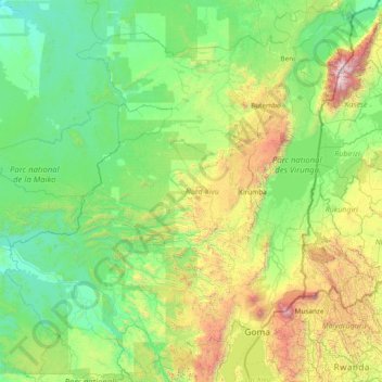
Name: North Kivu topographic map, elevation, terrain.
Location: North Kivu, Democratic Republic of the Congo (-2.06577 27.22667 0.95420 29.98730)
Average elevation: 3,901 ft
Minimum elevation: 1,739 ft
Maximum elevation: 16,066 ft
Make a donation
Gear up for your next adventure:
As an Amazon Associate, this site earns from qualifying purchases at no extra cost to you.
Other topographic maps
Click on a map to view its topography, its elevation and its terrain.
Make a donation
Gear up for your next adventure:
As an Amazon Associate, this site earns from qualifying purchases at no extra cost to you.
Make a donation
Gear up for your next adventure:
As an Amazon Associate, this site earns from qualifying purchases at no extra cost to you.
Make a donation
Gear up for your next adventure:
As an Amazon Associate, this site earns from qualifying purchases at no extra cost to you.
Make a donation
Gear up for your next adventure:
As an Amazon Associate, this site earns from qualifying purchases at no extra cost to you.
Make a donation
Gear up for your next adventure:
As an Amazon Associate, this site earns from qualifying purchases at no extra cost to you.
Make a donation
Gear up for your next adventure:
As an Amazon Associate, this site earns from qualifying purchases at no extra cost to you.
Make a donation
Gear up for your next adventure:
As an Amazon Associate, this site earns from qualifying purchases at no extra cost to you.
Make a donation
Gear up for your next adventure:
As an Amazon Associate, this site earns from qualifying purchases at no extra cost to you.
Democratic Republic of the Congo
Democratic Republic of the Congo
The tropical climate also produced the Congo River system which dominates the region topographically along with the rainforest it flows through, though they are not mutually exclusive. The name for the Congo state is derived in part from the river. The river basin (meaning the Congo River and all of its myriad…
Average elevation: 2,352 ft
Kisangani
Democratic Republic of the Congo > Tshopo
Kisangani is at the center of the Tshopo, and is bordered by Banalia Territory to the north, Ubundu and Opala territories to the south, Isangi to the west, and Bafwasende municipalities to the east. The city of Kisangani lies 324 km from Buta, 572 kilometres (355 mi) from Isiro, 696 kilometres (432 mi) from…
Average elevation: 1,362 ft
Make a donation
Gear up for your next adventure:
As an Amazon Associate, this site earns from qualifying purchases at no extra cost to you.
Make a donation
Gear up for your next adventure:
As an Amazon Associate, this site earns from qualifying purchases at no extra cost to you.
Make a donation
Gear up for your next adventure:
As an Amazon Associate, this site earns from qualifying purchases at no extra cost to you.
Make a donation
Gear up for your next adventure:
As an Amazon Associate, this site earns from qualifying purchases at no extra cost to you.
Make a donation
Gear up for your next adventure:
As an Amazon Associate, this site earns from qualifying purchases at no extra cost to you.
Lava Lake of Mount Nyiragongo
Democratic Republic of the Congo > North Kivu > Nyiragongo
Average elevation: 10,118 ft
Make a donation
Gear up for your next adventure:
As an Amazon Associate, this site earns from qualifying purchases at no extra cost to you.
Kamakombe
Democratic Republic of the Congo > South Kivu > Kabare > Kamakombe
Average elevation: 5,774 ft
Make a donation
Gear up for your next adventure:
As an Amazon Associate, this site earns from qualifying purchases at no extra cost to you.
Make a donation
Gear up for your next adventure:
As an Amazon Associate, this site earns from qualifying purchases at no extra cost to you.
Make a donation
Gear up for your next adventure:
As an Amazon Associate, this site earns from qualifying purchases at no extra cost to you.
Make a donation
Gear up for your next adventure:
As an Amazon Associate, this site earns from qualifying purchases at no extra cost to you.