
Make a donation
Gear up for your next adventure:
As an Amazon Associate, this site earns from qualifying purchases at no extra cost to you.
Regnitzlosau topographic map
Click on the map to display elevation.
Make a donation
Gear up for your next adventure:
As an Amazon Associate, this site earns from qualifying purchases at no extra cost to you.
About this map
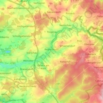
Name: Regnitzlosau topographic map, elevation, terrain.
Location: Regnitzlosau, Landkreis Hof, Bayern, 95194, Deutschland (50.26197 11.97534 50.33609 12.12628)
Average elevation: 1,850 ft
Minimum elevation: 1,526 ft
Maximum elevation: 2,172 ft
Make a donation
Gear up for your next adventure:
As an Amazon Associate, this site earns from qualifying purchases at no extra cost to you.
Other topographic maps
Click on a map to view its topography, its elevation and its terrain.
Schweinsbach
Deutschland > Bayern > Landkreis Hof > Münchberg
Das recht raue Klima im Münchberger Land beruht auf der Höhenlage. Es zeichnet sich durch hohe Niederschlagsmengen in Verbindung mit niedrigen Temperaturen aus. Die Jahresmitteltemperatur liegt bei nur 5–6 °C, während sie im nahen Bayreuth bereits bei 7–8 °C liegt. Die mittlere Lufttemperatur der…
Average elevation: 1,890 ft
Make a donation
Gear up for your next adventure:
As an Amazon Associate, this site earns from qualifying purchases at no extra cost to you.
Marlesreuth
Deutschland > Bayern > Landkreis Hof > Naila
Das Pfarrdorf liegt auf einem Höhenzug des Frankenwaldes und ist von Acker- und Grünland umgeben. Die Staatsstraße 2158 führt an Molkenbrunn vorbei zur Bundesstraße 173 bei Naila (2,5 km nördlich) bzw. nach Döbra zur Staatsstraße 2194 (3 km südwestlich). Die Kreisstraße HO 33 führt nach Selbitz zur…
Average elevation: 1,952 ft
Make a donation
Gear up for your next adventure:
As an Amazon Associate, this site earns from qualifying purchases at no extra cost to you.
Make a donation
Gear up for your next adventure:
As an Amazon Associate, this site earns from qualifying purchases at no extra cost to you.
Stobersreuth
Deutschland > Bayern > Landkreis Hof > Schwarzenbach a.d.Saale
Average elevation: 1,739 ft
Martinlamitz
Deutschland > Bayern > Landkreis Hof > Schwarzenbach a.d.Saale
Average elevation: 1,804 ft
Schwingen
Deutschland > Bayern > Landkreis Hof > Schwarzenbach a.d.Saale
Einzige Zufahrt ist eine Stichstraße, die in Höhe der Stadt Schwarzenbach nach Norden von der Bundesstraße 289 abzweigt. Im Westen des Ortes verläuft die Saale, im Osten die Lamitz. Der Jean-Paul-Weg führt durch den Ort.
Average elevation: 1,716 ft
Make a donation
Gear up for your next adventure:
As an Amazon Associate, this site earns from qualifying purchases at no extra cost to you.
Make a donation
Gear up for your next adventure:
As an Amazon Associate, this site earns from qualifying purchases at no extra cost to you.
Make a donation
Gear up for your next adventure:
As an Amazon Associate, this site earns from qualifying purchases at no extra cost to you.
Rothleiten
Deutschland > Bayern > Landkreis Hof
Bartelsmühle | Berg | Blumenaumühle | Brandstein | Bruck | Bruckmühle | Bug | Eisenbühl | Erzengel | Feldmühle | Geiersberg | Gottsmannsgrün | Gupfen | Hadermannsgrün | Holler | Lerchenhaag | Lohwiese | Ludwigshöhe | Maihof | Mitteltiefengrün | Moos | Obertiefengrün | Rothleiten | Rudolphstein |…
Average elevation: 1,975 ft
Geiersberg
Deutschland > Bayern > Landkreis Hof > Eisenbühl
Bartelsmühle | Berg | Blumenaumühle | Brandstein | Bruck | Bruckmühle | Bug | Eisenbühl | Erzengel | Feldmühle | Geiersberg | Gottsmannsgrün | Gupfen | Hadermannsgrün | Holler | Lerchenhaag | Lohwiese | Ludwigshöhe | Maihof | Mitteltiefengrün | Moos | Obertiefengrün | Rothleiten | Rudolphstein |…
Average elevation: 1,824 ft
Make a donation
Gear up for your next adventure:
As an Amazon Associate, this site earns from qualifying purchases at no extra cost to you.
Ochsenbrunn
Deutschland > Bayern > Landkreis Hof > Helmbrechts
Sonstige Wohnplätze: Buckel | Haide | Jägersruh | Kollerhammer (Kleinschwarzenbach) | Neubühl | Rappetenreuth (Oberweißenbach) | Rappetenreuth (Wüstenselbitz) | Spörlmühle | Steinbühl | Steinmühle | Suttenbach (Kleinschwarzenbach) | Suttenbach (Oberweißenbach) | Thomashölzlein | Wahlhöhe
Average elevation: 2,169 ft
Make a donation
Gear up for your next adventure:
As an Amazon Associate, this site earns from qualifying purchases at no extra cost to you.
Isaar
Deutschland > Bayern > Landkreis Hof
Das Kirchdorf Isaar befindet sich südwestlich von Töpen und ist über die Bundesstraße 2 und die Kreisstraße HO 2 verkehrsmäßig erreichbar. Zudem liegt die Gemarkung in einer landwirtschaftlich genutzten höheren Ebene der Mittelgebirgslandschaft zwischen dem Thüringer Schiefergebirge, dem Saaletal und…
Average elevation: 1,713 ft
Sachsenvorwerk
Deutschland > Bayern > Landkreis Hof
Bartelsmühle | Berg | Blumenaumühle | Brandstein | Bruck | Bruckmühle | Bug | Eisenbühl | Erzengel | Feldmühle | Geiersberg | Gottsmannsgrün | Gupfen | Hadermannsgrün | Holler | Lerchenhaag | Lohwiese | Ludwigshöhe | Maihof | Mitteltiefengrün | Moos | Obertiefengrün | Rothleiten | Rudolphstein |…
Average elevation: 1,696 ft
Make a donation
Gear up for your next adventure:
As an Amazon Associate, this site earns from qualifying purchases at no extra cost to you.
Großer Waldstein
Deutschland > Bayern > Landkreis Hof > Zell
Das Waldsteinhaus ist ein ganzjährig bewirtschaftetes Unterkunftshaus des Fichtelgebirgsvereins in unmittelbarer Nähe des Gipfels des Großen Waldsteins auf einer Höhe von 855 m ü. NN.
Average elevation: 2,461 ft
Großer Kornberg
Deutschland > Bayern > Landkreis Hof > Schwarzenbach a.d.Saale
Der Große Kornberg mit seinem 827 Meter hohen Gipfel ist der nordöstliche Eckpfeiler des Fichtelgebirges. Er ist der höchste Berg auf dem bewaldeten Höhenrücken des Kornberg-Massivs, der schon von Weitem durch den ehemaligen Aufklärungsturm der Bundeswehr erkennbar ist, und der Hausberg von Schönwald…
Average elevation: 2,293 ft
Rauschenhammermühle
Deutschland > Bayern > Landkreis Hof > Schwarzenbach a.Wald > Schwarzenstein > Rauschenhammermühle
Average elevation: 1,988 ft
Make a donation
Gear up for your next adventure:
As an Amazon Associate, this site earns from qualifying purchases at no extra cost to you.
Kleinschmiedenhammer
Deutschland > Bayern > Landkreis Hof > Schauenstein > Uschertsgrün > Kleinschmiedenhammer
Average elevation: 1,883 ft
Make a donation
Gear up for your next adventure:
As an Amazon Associate, this site earns from qualifying purchases at no extra cost to you.
Make a donation
Gear up for your next adventure:
As an Amazon Associate, this site earns from qualifying purchases at no extra cost to you.
Hadermannsgrün
Deutschland > Bayern > Landkreis Hof
Bartelsmühle | Berg | Blumenaumühle | Brandstein | Bruck | Bruckmühle | Bug | Eisenbühl | Erzengel | Feldmühle | Geiersberg | Gottsmannsgrün | Gupfen | Hadermannsgrün | Holler | Lerchenhaag | Lohwiese | Ludwigshöhe | Maihof | Mitteltiefengrün | Moos | Obertiefengrün | Rothleiten | Rudolphstein |…
Average elevation: 1,919 ft
Make a donation
Gear up for your next adventure:
As an Amazon Associate, this site earns from qualifying purchases at no extra cost to you.