
Kigali City topographic map
Interactive map
Click on the map to display elevation.
About this map
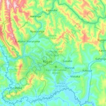
Name: Kigali City topographic map, elevation, terrain.
Location: Kigali City, Rwanda (-2.07982 29.97953 -1.77958 30.27987)
Average elevation: 5,007 ft
Minimum elevation: 4,370 ft
Maximum elevation: 7,100 ft
Kigali is located in the centre of Rwanda, at 1°57′S 30°4′E. Like the rest of Rwanda it uses Central Africa Time, and is two hours ahead of Coordinated Universal Time (UTC+02:00) throughout the year. The city is coterminous with the province of Kigali, one of the five provinces of Rwanda introduced in 2006 as part of a restructuring of local government in the country. The city has boundaries with the Northern, Eastern and Southern provinces. It is divided into three administrative districts—Nyarugenge in the south west, Kicukiro in the south east, and Gasabo, which occupies the northern half of the city's territory. The built-up urban area covers about 70 per cent of the municipal boundaries. Kigali lies in a region of rolling hills, with a series of valleys and ridges joined by steep slopes. It is situated between Mount Kigali and Mount Jali, both of which have elevations of more than 1,800 m (5,906 ft) above sea level, while the lowest areas of the city have an altitude of 1,300 m (4,265 ft). Geologically, Kigali is in a granitic and metasedimentary region, with lateritic soils on the hills and alluvial soils in the valleys.
Other topographic maps
Click on a map to view its topography, its elevation and its terrain.
Bugarama
Rwanda > Western Province > Rusizi
Bugarama, Rusizi, Western Province, Rwanda
Average elevation: 3,369 ft
Rubona
Rwanda > Southern Province > Huye > Rusatira
Rubona, Rusatira, Huye, Southern Province, Rwanda
Average elevation: 5,364 ft
Gisozi
Rwanda > Kigali City > Gasabo District
Gisozi, Gasabo District, Kigali City, Rwanda
Average elevation: 4,692 ft
Kibeho
Rwanda > Southern Province > Nyaruguru District
Kibeho, Nyaruguru District, Southern Province, Rwanda
Average elevation: 6,155 ft
Gatare
Rwanda > Southern Province > Nyamagabe
Gatare, Nyamagabe, Southern Province, Rwanda
Average elevation: 7,169 ft
Nyamata
Rwanda > Eastern Province > Bugesera District
Nyamata, Bugesera District, Eastern Province, Rwanda
Average elevation: 4,659 ft
Rubyiro
Rwanda > Southern Province > Nyamagabe > Buruhukiro
Rubyiro, Buruhukiro, Nyamagabe, Southern Province, Rwanda
Average elevation: 7,917 ft
Rwankuba
Rwanda > Northern Province > Gakenke > Rushashi
Rwankuba, Rushashi, Gakenke, Northern Province, Rwanda
Average elevation: 5,666 ft
Kayonza
Rwanda > Eastern Province > Kayonza District > Mukarange
Kayonza, Mukarange, Kayonza District, Eastern Province, Rwanda
Average elevation: 5,141 ft
Rubavu
Rwanda > Western Province > Rubavu
Rubavu, Gisenyi, Rubavu, Western Province, Rwanda
Average elevation: 5,902 ft
Muko
Rwanda > Northern Province > Gicumbi
Muko, Gicumbi, Northern Province, Rwanda
Average elevation: 5,856 ft
Mbuye
Rwanda > Southern Province > Ruhango
Mbuye, Ruhango, Southern Province, Rwanda
Average elevation: 5,213 ft
Bugesera District
Bugesera District, Eastern Province, Rwanda
Average elevation: 4,583 ft
Mayange
Rwanda > Eastern Province > Bugesera District
Mayange, Bugesera District, Eastern Province, Rwanda
Average elevation: 4,646 ft
Butare
Rwanda > Western Province > Rusizi
Butare, Rusizi, Western Province, Rwanda
Average elevation: 6,132 ft
Volcanoes National Park
Rwanda > Northern Province > Musanze
Volcanoes National Park, Musanze, Northern Province, Rwanda
Average elevation: 7,710 ft
Huye
Rwanda > Southern Province > Huye > Ngoma
Huye, Ngoma, Huye, Southern Province, Rwanda
Average elevation: 5,463 ft
Nyagatare
Rwanda > Eastern Province > Nyagatare District
Nyagatare, Nyagatare District, Eastern Province, Rwanda
Average elevation: 4,629 ft
Rugarama
Rwanda > Northern Province > Burera District > Rugarama
Rugarama, Burera District, Northern Province, Rwanda
Average elevation: 6,362 ft
Runyinya
Rwanda > Western Province > Ngororero > Runyinya
Runyinya, Hindiro, Ngororero, Western Province, Rwanda
Average elevation: 6,339 ft
Kirehe District
Rwanda > Eastern Province > Kirehe District
Kirehe District, Eastern Province, Rwanda
Average elevation: 4,747 ft
Kigali
Rwanda > Kigali City > Nyarugenge District
Kigali, Nyarugenge District, Kigali City, Rwanda
Average elevation: 5,020 ft
Rutsiro
Rutsiro, Western Province, KANEMBWE, Rwanda
Average elevation: 5,873 ft
Kicukiro
Rwanda > Kigali City > Kicukiro District
Kicukiro, Kicukiro District, Kigali City, Rwanda
Average elevation: 4,895 ft
Musanze
Rwanda > Northern Province > Musanze
Musanze, Northern Province, Rwanda
Average elevation: 7,372 ft
Nyaruguru
Rwanda > Southern Province > Nyaruguru District > Munini
Nyaruguru, Munini, Nyaruguru District, Southern Province, Rwanda
Average elevation: 6,207 ft
Gasabo
Rwanda > Kigali City > Gasabo District
Gasabo, Gasabo District, Kigali City, Rwanda
Average elevation: 4,777 ft
Gisenyi
Rwanda > Western Province > Gisenyi
Gisenyi, Rubavu, Western Province, Rwanda
Average elevation: 5,125 ft
Kigoma
Rwanda > Southern Province > Kigoma
Kigoma, Huye, Southern Province, Rwanda
Average elevation: 5,640 ft
Rungu
Rwanda > Western Province > Matyazo
Rungu, Matyazo, Ngororero, Western Province, Rwanda
Average elevation: 6,079 ft
Nyarugenge District
Nyarugenge District, Kigali City, Rwanda
Average elevation: 4,875 ft
Rwamagana
Rwanda > Eastern Province > Rwamagana District
Rwamagana, Kigabiro, Rwamagana District, Eastern Province, Rwanda
Average elevation: 4,948 ft
Mount Karisimbi
Rwanda > Northern Province > Gataraga
Mount Karisimbi, Gataraga, Musanze, Northern Province, Rwanda
Average elevation: 12,874 ft