
吉林高新技术产业开发区 topographic map
Interactive map
Click on the map to display elevation.
About this map
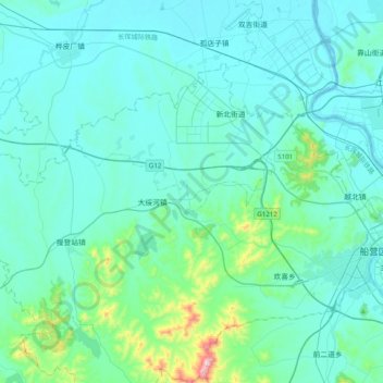
Name: 吉林高新技术产业开发区 topographic map, elevation, terrain.
Location: 吉林高新技术产业开发区, 船营区, 吉林市, 吉林省, 中国 (43.77990 126.22838 43.96988 126.62073)
Average elevation: 778 ft
Minimum elevation: 571 ft
Maximum elevation: 2,477 ft
Other topographic maps
Click on a map to view its topography, its elevation and its terrain.