
Rosetown topographic map
Click on the map to display elevation.
About this map
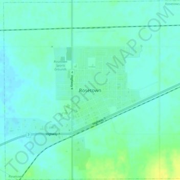
Name: Rosetown topographic map, elevation, terrain.
Location: Rosetown, Saskatchewan, S0L 2V0, Canada (51.53993 -108.01451 51.56980 -107.96630)
Average elevation: 1,929 ft
Minimum elevation: 1,909 ft
Maximum elevation: 1,975 ft
Other topographic maps
Click on a map to view its topography, its elevation and its terrain.
Onion Lake
Canada > Saskatchewan > Division No. 17 > Frenchman Butte No. 501
Average elevation: 2,024 ft
Beauval
Canada > Saskatchewan > Northern Saskatchewan Administration District > Beauval
Average elevation: 1,424 ft
La Loche
Canada > Saskatchewan > Northern Saskatchewan Administration District > La Loche
Average elevation: 1,467 ft
Pelican Narrows
Canada > Saskatchewan > Northern Saskatchewan Administration District > Pelican Narrows
Average elevation: 1,053 ft
Cranberry Flats Conservation Area
Canada > Saskatchewan > Corman Park No. 344
Average elevation: 1,624 ft
Good Spirit Lake
Canada > Saskatchewan > Division No. 9 > Good Lake No. 274
Average elevation: 1,578 ft
Last Mountain Lake
Canada > Saskatchewan > Division No. 6 > McKillop No. 220
Average elevation: 1,617 ft
Little Fishing Lake
Canada > Saskatchewan > Division No. 17 > Loon Lake No. 561
Average elevation: 2,024 ft
Paradise Hill
Canada > Saskatchewan > Division No. 17 > Frenchman Butte No. 501
Average elevation: 2,123 ft
McClean Lake
Canada > Saskatchewan > Division No. 18 > Unorganized Division No. 18
Average elevation: 1,444 ft
Grasslands National Park of Canada
Canada > Saskatchewan > Waverley No. 44
Average elevation: 2,694 ft