
Tiber topographic map
Click on the map to display elevation.
About this map
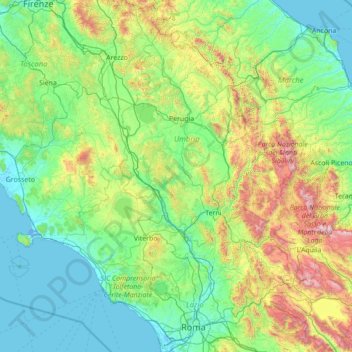
Name: Tiber topographic map, elevation, terrain.
Location: Tiber, Italy (41.74515 12.02487 43.78924 12.63874)
Average elevation: 1,371 ft
Minimum elevation: -16 ft
Maximum elevation: 8,924 ft
Other topographic maps
Click on a map to view its topography, its elevation and its terrain.
Passo dello Stelvio
Italy > Trentino-Alto Adige/Südtirol > South Tyrol > Stilfs - Stelvio
The Stelvio Pass (Italian: Passo dello Stelvio [passo ˈdello ˈstɛlvjo], Giogo dello Stelvio [dʒɔgo ˈdello ˈstɛlvjo]; German: Stilfser Joch; [ˈʃtɪlfsɐ jɔx]) is a mountain pass in northern Italy bordering Switzerland at an elevation of 2,757 m (9,045 ft) above sea level. It is the highest paved…
Average elevation: 8,937 ft
Rome
Italy > Lazio > Roma Capitale
Although the city centre is about 24 km (15 mi) inland from the Tyrrhenian Sea, the city territory extends to the shore, where the south-western district of Ostia is located. The altitude of the central part of Rome ranges from 13 m (43 ft) above sea level (at the base of the Pantheon) to 139 m (456 ft) above…
Average elevation: 256 ft
Seiser Alm-Gruppe - Gruppo Mont de Sëuc - Gruppo dell'Alpe di Siusi
Italy > Trentino – Alto Adige/Südtirol > South Tyrol > Kastelruth - Castelrotto
Seiser Alm (Italian: Alpe di Siusi, Ladin: Mont Sëuc) is a Dolomite plateau and the largest high-elevation Alpine meadow (German: Alm) in Europe. Located in Italy's South Tyrol province in the Dolomites mountain range, it is a major tourist attraction, notably for skiing and hiking.
Average elevation: 4,810 ft
Mount Etna
Italy > Sicily > Maletto > Adrano
During the first 1500 years AD, many eruptions went unrecorded (or records have been lost); among the more significant are: (1) an eruption in about 1030 AD near Monte Ilice on the lower southeast flank, which produced a lava flow that travelled about 10 km, reaching the sea north of Acireale; the villages of…
Average elevation: 3,796 ft
Dolina Seghina / Šeginov Dol
Italy > Friuli-Venezia Giulia > Trieste > Gabrovizza / Gabrovec > Stazione di Prosecco / Proseška Postaja
Average elevation: 817 ft
Gisse
Italy > Trentino – Alto Adige/Südtirol > South Tyrol > Ahrntal - Valle Aurina
Average elevation: 4,488 ft
Pila
There are more than 24 pistes (>70 km total length), including 4 blue runs, 29 red runs and 4 black runs, with a pipe zone and a slopestyle zone. There is one cable car, 3 gondolas, 8 chairlifts and 5 conveyors. The resort itself is at 1,814 metres altitude, while the highest skiing can be done at 2,700m.
Average elevation: 5,961 ft
Gruppo del Catinaccio
Italy > Trentino-Alto Adige/Südtirol > Provincia di Trento
Average elevation: 6,112 ft
Piz Boè
Italy > Trentino – Alto Adige/Südtirol > South Tyrol > Corvara in Badia - Corvara
Piz Boè is the highest mountain of the Sella group, a mountain range in the Dolomites, Italy. It has an elevation of 3,152 metres (10,341 ft).
Average elevation: 8,740 ft
Colle Fauniera
Italy > Piedmont > Cuneo > Demonte
The Colle Fauniera is a mountain pass in the Cottian Alps, Piedmont, northern Italy, located at 2,480+ m elevation.
Average elevation: 7,595 ft
Karer See - Lago di Carezza
Italy > Trentino-Alto Adige/Südtirol > South Tyrol > Karersee - Carezza
The lake is located in the western Dolomites on the edge of the Latemarwald, just 20 kilometers southeast of Bolzano at 1520 m altitude in the municipality Welschnofen. The nearest settlement is Carezza. The roughly 300 m long and 140 m wide stretch of water is fed by underground springs from the Latemar…
Average elevation: 5,269 ft
Pieve di Cadore
Italy > Veneto > Belluno > Pieve di Cadore > Pieve di Cadore
Average elevation: 3,661 ft
Meransen - Maranza
Italy > Trentino – Alto Adige/Südtirol > South Tyrol
Meransen (Italian: Maranza) is a village in South Tyrol, Italy, in the Mühlbach municipality between Pustertal and Eisacktal. It located on the slopes of the Gitschberg mountain at an altitude of 1,414 m (4,639 ft).
Average elevation: 4,196 ft
Bussana Vecchia
Italy > Liguria > Imperia > Sanremo > Poggio di Sanremo > Bussana Vecchia
Average elevation: 374 ft
Fiume Brenta
Italy > Trentino-Alto Adige/Südtirol > Provincia di Trento > Caldonazzo > Brenta
Average elevation: 1,542 ft
Vajont dam
Italy > Friuli-Venezia Giulia > Pordenone > Erto e Casso > Casso
Average elevation: 2,920 ft
Oberglaning - Cologna di Sopra
Italy > Trentino-Alto Adige/Südtirol > South Tyrol > Jenesien - San Genesio Atesino
Average elevation: 2,769 ft
Spondinig - Spondigna
Italy > Trentino-Alto Adige/Südtirol > South Tyrol > Schluderns - Sluderno
Average elevation: 3,553 ft
Klobenstein - Collalbo
Italy > Trentino – Alto Adige/Südtirol > South Tyrol > Ritten - Renon
Average elevation: 3,724 ft
Kronplatz - Plan de Corones
Italy > Trentino-Alto Adige/Südtirol > South Tyrol > Bruneck - Brunico
The Kronplatz (Ladin and Italian: Plan de Corones) is a mountain of the Dolomites in South Tyrol, northern Italy, with a summit elevation of 2,275 metres (7,464 ft) above sea level.
Average elevation: 6,407 ft
St. Zyprian - San Cipriano
Italy > Trentino-Alto Adige/Südtirol > South Tyrol
Average elevation: 4,770 ft
Sardagna
Italy > Trentino – Alto Adige/Südtirol > Provincia di Trento > Trento
Average elevation: 1,900 ft
St. Peter - San Pietro
Italy > Trentino-Alto Adige/Südtirol > South Tyrol > Lajen - Laion
Average elevation: 4,311 ft